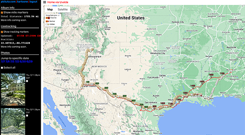
Let’s start out with a quick TLDR – my adventure totaled 4,077 miles with 2,715 miles of that being my 11th place finish (see pic above) in the 2022 Tour Divide southbound grand depart taking 18 days and 11 hours to complete over 16 rides. The remaining 1,362 miles included a 1,044 mile crossing of the state of Texas from El Paso, TX to Lake Charles, LA via the site of two recent mass shooting sites (Uvalde and Santa Fe) to raise awareness and remind people that inaction is not an option. After making it to the Louisiana border, I rode on through Louisiana crossing the Mississippi River before calling it quits (out of time and money) in Baton Rouge, LA where my friend Michael Rasch picked me up and drove me to New Orleans to catch a train back home to Birmingham. At the train station in Birmingham, my friend Doug Daughhetee met me and we biked together up and over Red Mountain and Shades Mountain to get back home. Interesting note – that final 15 mile ride had more climbing than the 153 mile ride the day before in Louisiana!
About 250 riders signed up for the Tour Divide race with 183 southbound riders actually taking to the start line in Banff, Canada on Friday, June 10th, in a series of 10 minute waves. As of July 11th, 63 riders have finished and 66 riders have scratched and 54 riders are still out on course. Sofiane Sehili won this year’s grand depart in 14 days, 16 hours. My 11th place finish was just over 4 days slower. I switched early in the race to survival mode and definitely did not push my pace or my sleep deprivation to the limits as I wanted to make sure I finished the race no matter what.
My wave of the race started on June 10th at 6:50AM in decent weather but rainy and snowy conditions in the mountains with unusual late season storms dumping so much snow on the mountains at the end of May and new storms dumping more snow during the race in the middle of June. Meanwhile, in the southern parts of the race (New Mexico) early season fires gave way to early monsoons which extinguished all the fires but left their marks with an unusual amount of rain and mud. Whenever I talked to locals or happened to catch the weather on a TV, I kept hearing the phrase “atmospheric river” covering the entire southwest and dumping so much rain with storm after storm after storm every single day.
New Mexico and all of its hot pavement detours (whenever it wasn’t raining) mixed with incredibly deep and sticky peanut butter mud for sections that weren’t re-routed was easily the hardest part of the race. But the northern sections (all of Canada and most of Montana) were far more dangerous given the number of bears and how much wind, rain, and snow there was. I did the whole race in sandals (carefully), but thirteen people who were still in the mountains when the winter storm hit had to be air lifted out of the Canadian wilderness.
After the race, my goal was to ride home to Alabama crossing Texas via Uvalde to see and pay my respects at the site of the recent mass school shooting and raising attention and awareness of the recurring nightmare of these terrible mass shootings. I was reminded through the lyrics of the Eminem song “Darkness” while I was biking in West Texas about a school shooting in East Texas in the small town of Santa Fe outside Houston. So I re-routed myself through that town as well.

It was unexpectedly and completely overwhelming to be standing in front of the memorials above. I couldn’t speak without sobbing so I didn’t say anything in my Facebook live video of the memorial. I cannot even imagine what it must be like for the parents and families and community members in both of those small towns to go through this horrible tragedy.
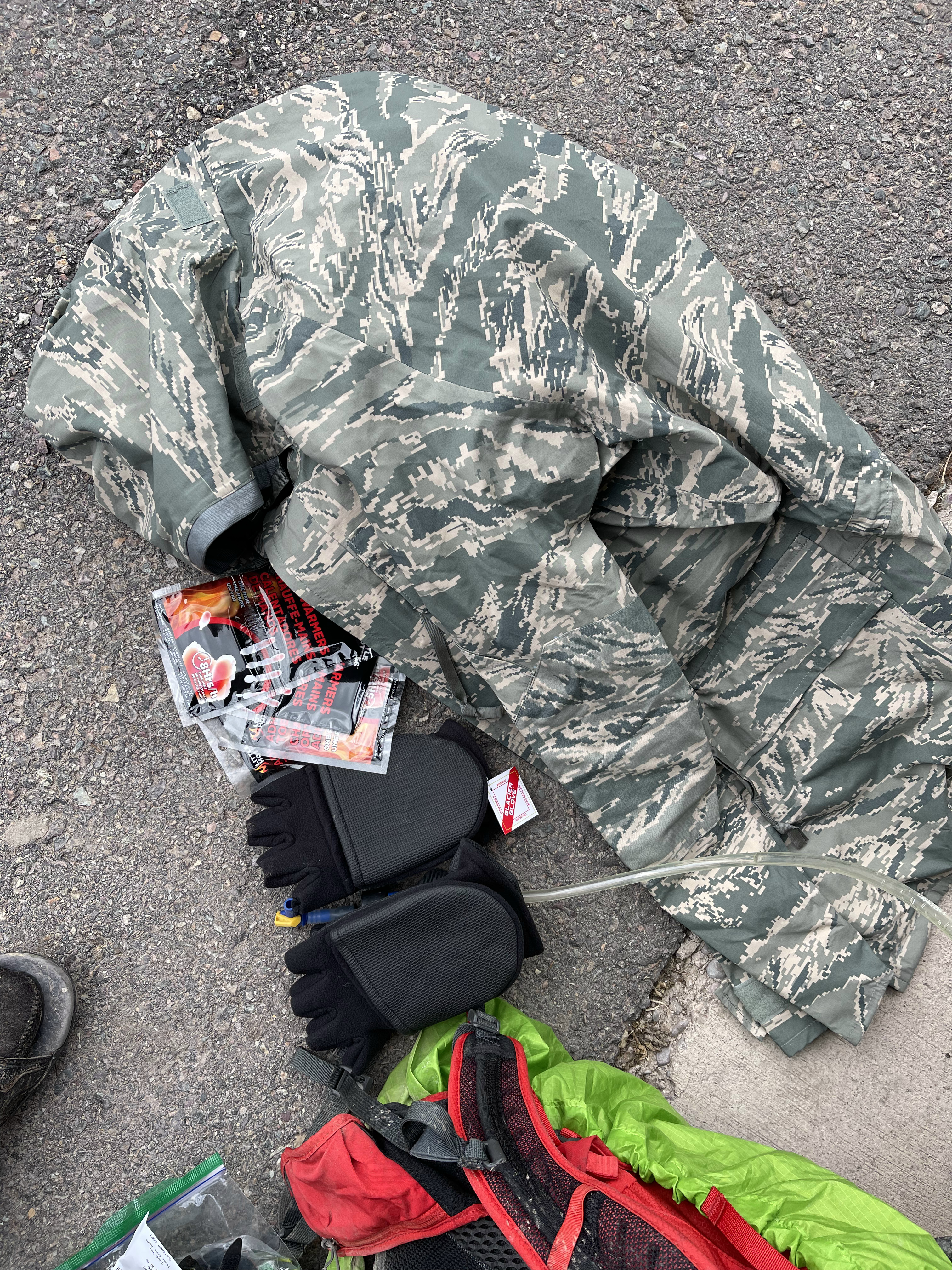
Crossing Texas took an entire week (1,044 miles) plus another 300 miles to cross the Mississippi River in Baton Rouge where I decided to call on a bikepacking friend (Michael Rasch) to pick me up and take me to the New Orleans train station so I could make it home before my kids left for camp the next day. Still, I was able to finish off the adventure with one final ride from the Birmingham train station up and over the local mountains back to my house down in the valley.
In summary, I am so thankful for the opportunity and freedom to race and ride my bike for so many miles this summer and to see and ride myself through so much wilderness and experience the beauty of North America and bear witness to the memorials of two mass school shootings in our great but tragically divided country.
MAPS

TLDR plus pics from all the individual days
I am splitting up my detailed recollection of the race and ride home into individual days that will end up being separate blog posts. For now, I’ve gone through and picked out my best pics that summarize each day and written up a TLDR summary. I’d like to point out how long the TLDR is for the most difficult bike ride of my entire life (Days 16-17 through the Gila National Forest). As I write each day, the day titles below will turn into hyperlinks to each day(s) write-up. Many of the write-ups I was able to voice dictate on my ride across Texas to Louisiana. Still, I’m going through all those dictations and filling in the blanks so it may be a while before all the links are active. If you revisit this page, be sure to hit the refresh button to reload the latest version of the page.
Part 1: The Tour Divide – 2,715 miles and 173,809 feet of climbing
      | Day 0 – Fri, 6/10 @ 6:36AM Banff, Canada to Fernie 158.5 mi – 13,297 ft – 16h 48m – Tough day So many amazing views of the sharp rocky mountains. My favorite was the Mt Shark area. Left turn off the long gravel road onto snow covered singletrack hike-a-bike off and on to an amazing snow free single-track descent followed by narrow suspension bridge – awesome. The strenuous koko claims hike-a-bike followed by snow mud hike-a-bike on the descent took a lot out of me. And with it getting cold and starting to rain hard, I decided to stop early at the Snow Valley Lodge in Fernie giving out hot free food and a 40% discount to racers for lodging. Especially since I had been passed by a racer on the climb before Fernie who mentioned that there were more snow covered passes that he was definitely not doing at night. That same racer also said “plenty of 16 day-ers have stopped in Fernie on the first night” when I mentioned I had planned on not stopping until the USA in order to make my time goal. Pics: 1) Fellow Alabamian Michael B, who started in a later wave, plus my son, my daughter, and my wife sending me off as seen from my Varia radar light camera at 6:50am. 2) Mount Shark. 3) Sharp rockies. 4) Looking back down the waterfall I just hiked up on koko claims. 5) Snow postholes and “lake” across top of koko claims. |
     | Day 1 – Sat, 6/11 @ 4:23AM Fernie, Canada to Eureka 119.7 mi – 9,790 ft – 16h 38m – Unexpectedly hard and short day I hadn’t researched this stretch after Fernie and was surprised by the two high snow-covered passes the racer from the previous day had mentioned – including one with a buried SUV to give an idea of the snow depth. But before that was the infamous “wall” that came on the CDT through a boggy partially flooded area that was complicated by several large fallen trees requiring navigation. One particularly steep slope had a huge tree down in the middle that required quite a bit of creativity to get over. Then the “wall” itself was quite muddy but a tad bit easier than the trees. No way to scale it, though, without clogging sandal with mud. The highlight of the day was getting caught by Theo (from Toronto) on the last descent before pavement back to the USA. We crossed the border together with the border patrol officer saying “Hi Brian, I just need to see your passport” (he was following trackleaders). Theo mentioned that he didn’t want to do one of the upcoming passes with steep drop-offs at night, so he would be camping early. Without a tent or sleeping bag, I didn’t really have that option so I stopped even earlier in Eureka checking into a motel at the gas station. Many rural motels for the rest of the race were the same with the gas station check-out counter doubling as motel check-in desk. Pics: 1) So many miles of snow hike-a-bike in sandals. 2) Postholes 3) Ford Explorer buried in the snow 4) Welcome home |
     | Day 2 – Sun, 6/12 @ 1:22AM Eureka, MT to Montana Hilton via Whitefish snow 207.4 mi – 14,140 ft – 24h 14m – Long “make-up” day finishing at a vault toilet I caught up to Tim Tait shortly after the second avalanche crossing. He was waiting to be sure a grizzly he had seen was gone. We rode together over that first pass and then up the next pass to the five mile Red Meadow pass snow hike-a-bike. Tim was much faster than me through the snow trying to keep my feet as dry and warm as possible in sandals. On the descent from the third pass of the day, I started a mama grizzly and her cub, followed by a black bear a few turns later. I ended the day riding with Andrew Strempke (single speeder). He opted to tent camp next to the road whereas I had to go a couple miles off course to a campground with a toilet for shelter from the rain. The toilet I found was a true “Montana Hilton” because it had electricity and running water (sink). I only slept from about 2:30-4:30AM. Pics: 1) The most beautiful picturesque winter scenes IN SUMMER during 5 miles of Red Meadow Pass hike-a-bike 2) Winter storm warning 3) Only filtered water once 4) Yard sale inside a Montana Hilton |
     | Day 3 – Mon, 6/13 @ 4:57AM Flathead National Forest, MT to Lincoln via Seeley Lake 101.8 mi – 8,136 ft – 16h 18m – An epic store stop I ran into Tim again and another rider early, and we climbed together to the most dangerous snow of the trip with sharp drop-offs down avalanche chutes. I got dropped on the snow hike-a-bike and on the long descent I was so wet and cold that when I came to a rise in the dirt road in the sun that had finally appeared, I stopped and stood there for 10 minutes in three layers of soaking wet clothes sheltered a little from the wind but still in the sun. I finally pulled myself away when the wind started blowing again and headed off course to Seeley Lake to resupply and dry off. I found a laundromat where I could shower, launder clothes, and charge electronics. It was a perfect and much needed break. The wind really started to pick up eventually a fairly steady 25+mph wind with gusts approaching 40-50mph. Thankfully it was almost all tailwind through Ovando and up the final pass before Lincoln with a huge winter storm bearing down on the course. Pics: 1) Dangerous snow hike-a-bike across avalanche slide 2) Wall drug shower cap keeping my head dry 3) Hunting store purchases 4) Ovando teepee |
     | Day 4 – Tue, 6/14 @ 6:48AM Lincoln, MT to Butte 141.1 mi – 14,656 ft – 17h 38m – This day had everything This day had it all – the most climbing per mile for the entire race with three passes and four big climbs, the most technical single-track for the entire race, the most traffic of the entire race, the strongest winds of the entire race (knocking me off my bike once) and knocking over trees uncomfortably close to me, finishing off with that wind as a headwind into Butte for many washboarded miles along a frontage road next to I-15 followed by a steep technical, confusing, night-time, single-track descent down into Butte. To cap it all off, I had problems at my resupply gas station and hotel check-in that led to me looking for food and lodging for what seemed like forever but was actually about 20 minutes of riding around like a chicken with its head cut off. Still, I had made it far enough into the race that the storm which dumped a LOT of snow ending or greatly slowing many people’s races just behind me only had a dusting of flurries on the top of the second climb where I briefly caught up to and met Zoe Chauderlot (leading the women’s race) before she promptly dropped me on the descent. Pics: 1) A fresh dusting of snow 2) Ridiculously windy tailwind up the pass 3) The llama ranch, free hostel for TD racers, I never hit one of these at a time remotely close to when it would make sense to stop 4) Overlooking Butte before dropping down STEEP singletrack |
     | Day 5 – Wed, 6/15 @ 6:38AM Butte, MT to a cave outside Lima 206 mi – 12,772 ft – 27h 23m – Sleeping in a cave A cold start turned into a nice day climbing up Fleecer Ridge. I was able to clear the steep single-track climb without dabbing, but I didn’t realize that it was notorious for its steep descent. Thankfully, I was able to panic bail without crashing before carefully walking/sliding down the rest of the 1,000′ drop eventually leading to the tiny town of Wise River which had a guestbook specifically for Tour Divide racers at the mercantile. It was the start of a nice, long paved section of the course albeit with a slight headwind. After many miles of pavement, I caught and passed Daniel Connell shortly after the turn onto the washboarded dirt road towards Bannack Rd. After the washboard, I went off course to resupply at the Horse Prairie saloon, but Daniel stayed on course (passing me) and stayed ahead of me for the rest of the race finishing one place in front of me. I ended the day sleeping in a cave on Bannack Rd when I got cold and very sleepy. Pics: 1) Steep Fleecer Mountain double track 2) Horse Prairie saloon resupply 3) Bannack Rd moonrise and stars 4) “Cave” nap |
     | Day 6 – Thu, 6/16 @ 10:02AM Lima, MT to Idaho via hot headwind hell 98.6 mi – 4,196 ft – 11h 11m – Hot headwind hell Shivering, I left the cave and headed to Lima where the cafe had FIVE of us eating and charging devices together by the time I left with a foil-wrapped burrito to go. From freezing in the morning, it quickly heated up with no shade at all along this 75 mile valley alternating between ok dirt and hard to ride washboard gravel. No shade at all and it was the first day that got really hot. With my giant hunting jacket taking up my entire backpack, I had to wear my long sleeve rain vest so I was ridiculously hot by the time I made it to a state park where I donated the hunting jacket. Afterwards I was distraught over how much I had spent and whether it was the right decision knowing that I would need it again. What sold me was knowing that I would not be able to finish the race lugging that jacket through all the hot sections of the race still to come. So I pressed on and started the climb towards West Yellowstone, crossing over into Idaho where it was now high enough to have trees and even some singletrack before hitting the busy Island Park area where I found a place to stay exhausted from the heat. Pics: 1) TD race bikes while TD racers enjoy home cooked grub 2) Storks? 3) Hot! 4) I would not have known I was crossing into Idaho except for this sign |
      | Days 7 and 8 – Fri, 6/17 @ 5:37AM Island Park, ID to Wyoming via Boulder bonus miles 250.3 mi – 14,291 ft – 39h 4m – “Falute” Cold, deep, wide water crossings gave way to dirt rails-to-trail where I nearly hit a fox. It was hot climbing into Yellowstone and Grand Teton National Parks through many dead trees from forest fires. A brief rain turned the dirt climb up Togwotee Mountain into peanut butter mud. I opted to have a nice dinner, do laundry, and nap before heading out again shortly after midnight. Negotiating the downhill snow and peanut butter mud hike-a-bike at night was a mistake. I made it down wet, muddy, and frozen but enjoyed a nice breakfast with three New Zealand riders who taught me the word “falute” meaning “pointless” to describe the route I had just taken – 4 hours wet, cold, and muddy vs 20 minutes perfectly fine to arrive at the same spot. I pulled away on the long, steep, snowy, muddy Union Pass climb topping out on a huge wind-swept plateau with an oppressive 360° view of 13,000+ foot peaks. Saw the ONLY blood of the entire trip on the descent when I impaled my leg on a sharp stick crossing an ATV mud hole. ATV trails gave way to pavement and tailwinds all the way to Pinedale. Beautiful double rainbow on my 22 bonus miles to/from Boulder (hotel was booked and had to backtrack 11 miles to Pinedale). Theo, Zoe, Steve Large, and I all spent the night in Pinedale arriving at about the same time. I was one mile short of 250 so I rode half a mile in the rain, turned around and rode back to the hotel on what was easily my most ridiculous Eddington 250 ride ever (until a week later when it would be surpassed). Pics: 1) 39 degF with LOTs of water to cross 2) Many amazing views of the Grand Tetons 3) An “oppressive” 360 deg view of 12k<14k foot peaks surrounding on all sides 4) Four hours to get through here with a snow hike/slide down the mountain 5) Double rainbow before having to backtrack 11 miles (22 BONUS miles) to end the day |
     | Days 9 and 10 – Sun, 6/19 @ 5:54AM Pinedale, WY to Colorado via the Great Basin 264.5 mi – 12,874 ft – 37h 3m – Surviving the Great Basin Getting to meet and ride with Steve Large as I left Pinedale made up for all the backtracking from the previous day. We endured storm after storm as we approached Atlantic City with Zoe riding on ahead of us a bit faster. The three of us ate at the saloon before tackling the 95 mile desolate stretch across the Great Basin. I was last to leave b/c a huge gust blew my stuff way down the dirt road outside the saloon. That wind was a tailwind for most of the basin. I could see Steve periodically a half mile or more ahead. At some point I realized that if he left me there would be nobody for a long time. So I hit it hard and caught back up to Steve right as we realized the huge storm building to our right was heading for us. With no shelter of my own, I had no choice but to ride through it. Neither of us wanted to get hit by it though so we were crushing it and wondering where Zoe was when we saw her waving at us from off the course at a HUGE oil shed that she had found. The storm was right on us by this point so we stopped and took shelter inside. The rain was over in less than an hour but the mud was so thick we decided to sleep and then head out at night when it had hopefully dried some. It had not dried and many peanut butter miles later, the sun rose and we made it to the Love’s truck stop. With still half a day left to ride, we decided to push on to Colorado and Brush Lodge which we had heard from north bounders was actually open. We all made it there at different times with Theo catching up to us and joining us there for short sleep. Pics: 1) Trying to outrun a thunderstorm on the Great Basin 2) Finding an unexpected shelter with Zoe and Steve 3) Finishing off the Great Basin with Zoe and Steve the next morning 4) Dirty bike after crossing the Great Basin |
     | Day 11 – Tue, 6/21 @ 4:05AM Brush Lodge, CO to Silverthorne via fav day 181.6 mi – 14,449 ft, 19h 23m – Favorite day of the trip This was by far my favorite day of the trip. Below freezing temps leaving Brush Lodge with lots of frost through the “hippie village” were offset by a steep climb that I decided I absolutely didn’t want to hike-a-bike, so I rode some pretty ridiculous grades leaving the others behind. I enjoyed playing Pokemon Go through Steamboat Springs on all the bike paths and enjoyed NOT riding dirt. It got hot through all the double track and singletrack after steamboat. After more climbing, the course dropped down to the Colorado River where there were many whitewater rafting groups … and mosquitoes. From the river on up the next climb there were so many mosquitoes. You had to go more than 10mph for them not to land on you and bite you, which was crazy because other places you could walk fast and they wouldn’t bother you. But near the Colorado River, they were ravenous. I stopped at the same gas station in Kremmling that I had stopped at on my ride from Alabama to Colorado last summer. One long dirt climb later through a mine and then down pavement into Silverthorne … well, no, down to a left turn that then climbed for 10 more miles gradually to Silverthorne and I was so thankful for a nice hotel. Pics: 1) My strategy for riding with temps down in the 20s in sandals 2) Lots of frost 3) The Colorado River much later in the day 4) A beautiful sunset climb that eventually turned to pavement |
     | Day 12 – Wed, 6/22 @ 5:22AM Silverthorne, CO to the Salida sonic 122.8 mi – 7,264 ft – 13h 19m – Bike paths and memories Started out great with more bike paths climbing all the way through Breckenridge. Stunning views. Long paved climb turned to dirt before cresting at 11,500′ at Boreas Pass followed by rough descent on CDT hiking singletrack, which eventually turned into purpose-built flowy mountain bike singletrack that eventually dumped you onto busy highway, which turned into the busiest and dustiest heavily washboarded dirt road of the race. I had my radar light on with how dangerous it was after a car passed. No close calls, just a lot of dust that died down when the rain storms started to hit, but fortunately no peanut butter mud. One final small climb had the only moose I saw of the whole trip. A long descent took me down into the sprawling Salida area where the route bypassed all the hotels, restaurants, and gas stations forcing more “bonus miles” to get to the Sonic and hotel Kristine and I had stayed in 10 years ago on the way to Leadville. Somewhat ironically, our AirBnB for the race was in Silverthorne! Pics: 1) Morning alpine glow outside Breckenridge 2) Top of Boreas Pass 3) Beginning of a long, busy, rough, dusty, washboarded road 4) Ominous sky looking south across the valley from Salida |
      | Day 13 – Thu, 6/23 @ 2:10AM Salida, CO to Del Norte via three big passes 153.2 mi – 10,148 ft – 16h 28m – Three big passes and an agonizing fourth little one Twenty-five miles straight up leaving the hotel into a cold headwind blowing down the mountain that led to stunning sunrise sky followed by a long gradual drop down to the restaurant at Sargents. Afterwards, two more passes that both went well, so well that I tried to hold up a three while taking a picture of the sign at the top of the third pass, thinking it would be all downhill to Del Norte where I would intersect with the Race Across America route I’ve ridden twice (2015 & 2017). Instead of heading straight into town on pavement, we veered onto a rough dirt road that climbed for agonizing 750 vertical feet before a long singletrack descent that would have been great if I wasn’t trying to beat a very dark storm. I wish I hadn’t stressed, though, because the storm never did make it to town. I stayed at a historic hotel that wouldn’t let me bring my bike to my room for fear of getting things dirty. Fair enough as they let me have access to it in the downstairs storage closet. Also, the owner gave me a heavily discounted rate, so that was great! Pics: 1) Top of Marshall Pass 2) Top of Cochetopa Pass 3) Top of Carnero Pass 4) Start of long, rough, fourth climb up Elephant Rocks 5) Intersection with the Race Across America Route in Del Norte |
     | Day 14 – Fri, 6/24 @ 2:24AM Del Norte, CO to Cuba via endless reroute 201.4 mi – 14,291 ft – 20h 47m – New Mexico without water … literally Leaving Del Norte, I started climbing immediately on pavement that led to steep gravel up to the highest point in the race (Indiana Pass – 11,925′). The views across the “top” were spectacular with many herds of elk. The long “descent” (tons of climbing) eventually dropped into the heavily touristed and washboarded Conejos River valley. Saturday morning traffic limited my “washboard navigation” options. It was rough and annoying after the upper part of the descent had been so nice. I celebrated after reaching pavement knowing that the next 300+ miles were all going to be on pavement. I didn’t realize how busy and hot the roads would be as I lost nearly all shade, starting with a 5 mile STEEP 1600 foot climb to get to the New Mexico border before descending down to the town of Chama that had been without water for TWO WEEKS! Porta-potties were setup at the gas station I resupplied at. I tackled the 100 mile detour to Cuba mid-afternoon with temps soaring. I stopped at two gas stations in the first twenty miles and a closed visitor center with outdoor water fountain AND hose. Also, having traveled so far south, the sun was setting closer to 8:30pm instead of 9:30pm. Temps cooled off quickly, and I made it to Cuba with two full bottles I hadn’t even touched. Pics: 1) Top of Indiana Pass, highest point in the race – 11,925′ 2) One of the views still across the “top” 3) Colorful iron ore mountains climbing out of valley after Indiana Pass 4) Cool chalkboard check-in at very expensive lodge where I paid $4 for a cliff bar and $3 for a plain coffee and opted NOT to pay for wi-fi. |
      | Day 15 – Sat, 6/25 @ 6:02AM Cuba, NM to Grants via the Navajo Nation Reservation 122.5 mi – 4,308 ft – 10h 43m – Deino community day According to my maps, it looked this entire 122.5 mile ride would have no resupply, but the Navajo Nation had a very nice gas station / laundromat with free wifi that I hit right at the start of the Pokemon Go deino community day event. I didn’t think there would be cellphone coverage so I spent 10 minutes catching the unusually large number of Pokemon there. As it turns out, there was cellphone coverage across the entire reservation except for short forays down into canyons. This meant I could catch deinos, a valuable pokemon, for the entire three hours of the event. I had already been riding for five hours, which meant only two more hours after the event was over. Thankfully, this was a short day given how ridiculously tough the next day would be. As I got closer to Grants, I noticed mud and dirt leftover from flooded roads with orange safety cones still present. This was an ominous sign, especially with more storms threatening. Pics: 1) A lonnnnng ways to anywhere. Also, my only other ride in New Mexico was racing 24 hour mountain bike nationals in Gallup in 2014. 2) Lots of Deinos at the laundromat / store / gas station not on my maps 3) Free wi-fi 4) Foreshadowing of what lay ahead 4) Historic route US Hwy 66 in Grants, NM |
               | Days 16 and 17 – Sun, 6/26 @ 5:11AM Grants, NM to Silver City via toughest ride ever 270.6 mi – 16,198 ft – 40h 6m – The toughest thing I have ever done Even before falling asleep, I heard the next storm hit Grants. It was still raining as I left, but it stopped for my beautiful sunrise ride through El Malpais National Monument leaving a few tricky water crossings without mud. I was nervous about the dirt road to Pietown, which thankfully was gravelly enough to be mostly free of mud. As I climbed towards Pietown, there was less gravel and more mud but still rideable until the next big storm hit as I made it to the restaurant. Knowing what I had just ridden would now be impassable, I was “concerned” about my plans – 120 miles arriving in Glenwood well after midnight. I stopped by the deserted Toaster House (free hostel for divide racers) and formulated a plan – turn back and stay at the hostel if I encountered mud early, otherwise continue and sleep as needed in shelters along the way. It was thick gravel for many miles intermixed with muddy sections I could still make it through taking a careful line. When I realized it was too late to turn around and I still had 100+ miles without resupply, I was terrified but kept going hoping for the best and ran into peanut butter mud after another 20 miles. It was bad – could not turn the wheels or keep the chain on the chainring. After cleaning for a while, I was able to push the bike again for a half a mile until I was back to more gravelly roads. A few minutes later, I ran into a northbounder and warned her about the mud. I asked if there was shelter at the highway I would be crossing soon. She said people at a small Mormon church had given her water, but it was deserted and locked by the time I arrived. Pics: 1) Flooded roadway early in ride 2) Ventana Arch 3) Threatening storms on Pietown Rd 4) Cool rolling dirt hills with more rain approaching Pietown Staring at a wall of rain approaching, I opted to rest for a bit on the tiny patio. I fell asleep, eventually waking up cold and realizing the rain had stopped. I packed up and headed out on deep but rideable gravel. By the national forest, the roads had gotten narrow and muddy and I was getting very sleepy from all the stress. I decided to sleep at the first shelter I saw. Many miles later, I realized that there would be no shelter and started looking for larger trees as the rain started to pick up. I found a large tree that was dry underneath. I fell asleep, but was woken by thunder. I took off but got sleepy again many miles later. Eventually I would sleep two more times underneath trees while struggling through miles of unrideable mud between naps. As it got closer to morning, I was getting very cold from the steady rain with temps dipping down into the mid 40s, but thankfully I had a long climb to warm me up at sunrise. Pics: 1) Pietown Cafe 2) Menu 3) List of pies 4) New Mexico poutine Unfortunately, at the top of that climb was a 4,000 vertical foot descent where I discovered my front brake pads were completely gone. I almost ran into a rock wall at the very first turn. So I had to do that long descent very slowly with only my rear brake hoping to be able to bail off the bike in case I lost that brake, too. I had replacement brake pads, but my hands were so frozen and damaged that I had no hope of changing it without warming up first. By the time I made it down to Mogollon it was 8am on a Monday morning and everything was closed and wouldn’t open until the following weekend. I crashed when turning around to check again if the store was really closed. It was. Pics: 1) Toaster house 2) Sign at toaster house plus my reflection 3) Wall of rain from the Mormon Church patio Thankfully, the shop owner was following trackleaders and had driven out to meet me with trail angel magic. I was able to warm up my hands enough to change out my front brake pads before pressing on to Glenwood, which I didn’t reach until almost noon. After the Glenwood store, I was refreshed, resupplied, and ready to ride 75 miles to Silver City. A flash food forced a re-route, but thankfully that was after I made it through the 20 mile potential peanut butter mud section that stayed dry with storms threatening. It was hot (100 degF by late afternoon) with tons of climbing as there were many canyons to cross. So much climbing, but eventually I did make it to Silver City, home of the Tour of the Gila professional bike race that I was never able to do during my racing days. Pics: 1) Standing amongst so many frogs thankful for place to clean the peanut butter mud off my bike and sandals 2) Potential peanut butter mud, but thankfully I made it through ahead of the afternoon storms 3) A flash flood from one of those afternoon storms somewhere in area To cap off this ridiculous 40 hour day, most of the hotels were booked and the historic hotel I found had one room left … on the fourth floor … with a broken elevator. Yes, I lugged my bike up four flights of stairs before sleeping and then back down the next morning. |
     | Day 18 – Tue, 6/28 @ 5:33AM Silver City, NM to the finish in Antelope Wells 122.9 mi – 2,999 ft – 12h 27m – Finishing the Tour Divide on our 19 year anniversary This day was quite tame by comparison but still hard. Fast, rolling tailwind for 20 miles on a busy highway followed by nearly 30 miles of gradual descending on mostly sandy dirt, but occasional stretches of peanut butter mud eventually led to I-10 marking the final interstate crossing (I crossed all of them!). After resupply at the historic Continental Divide trading post, I hit the awful washboarded frontage road into a stiff headwind and celebrated after finally making it to pavement that would take me down to Hatchita and Mexico. I had been hoping to make it to the border before it closed, but I knew that I would miss it by a couple hours so I began thinking about crossing into Mexico on my ride back across the country to get home. At the finish, Jeff Sharp took lots of pics and shuttled me back up to Hatchita to save me 45 miles of riding back up to his bike ranch so I could get some extra sleep before heading out to El Paso in the middle of the night to beat the heat. It was great meeting Jeff and he took one of my favorite pics of the race back at the store in Hatchita – me pointing at my bouncing trackleaders icon meaning I had successfully finished the race! Pics: 1) Deep water to clean off peanut butter mud on final day 2) Tarantula 3) Washboard along I-10 4) Sunset sky from Jeff Sharp’s Bike Ranch after finishing the race Below) Me pointing at my bouncing trackleaders dot back at the Hatchita gas station after the finish. \  |
| Totals – 2,715 mi – 173,809 ft – 18 days 11 hours elapsed |
Part 2: Riding home across Texas via Uvalde and Santa Fe – 1,362 miles and 20,220 ft of climbing
 | Day 1 – Wed, 6/29 @ 2:46AM Hatchita, NM to El Paso, TX 123.9 mi – 1,565 ft – 10h 17m – There is a lot of border patrol in New Mexico. |
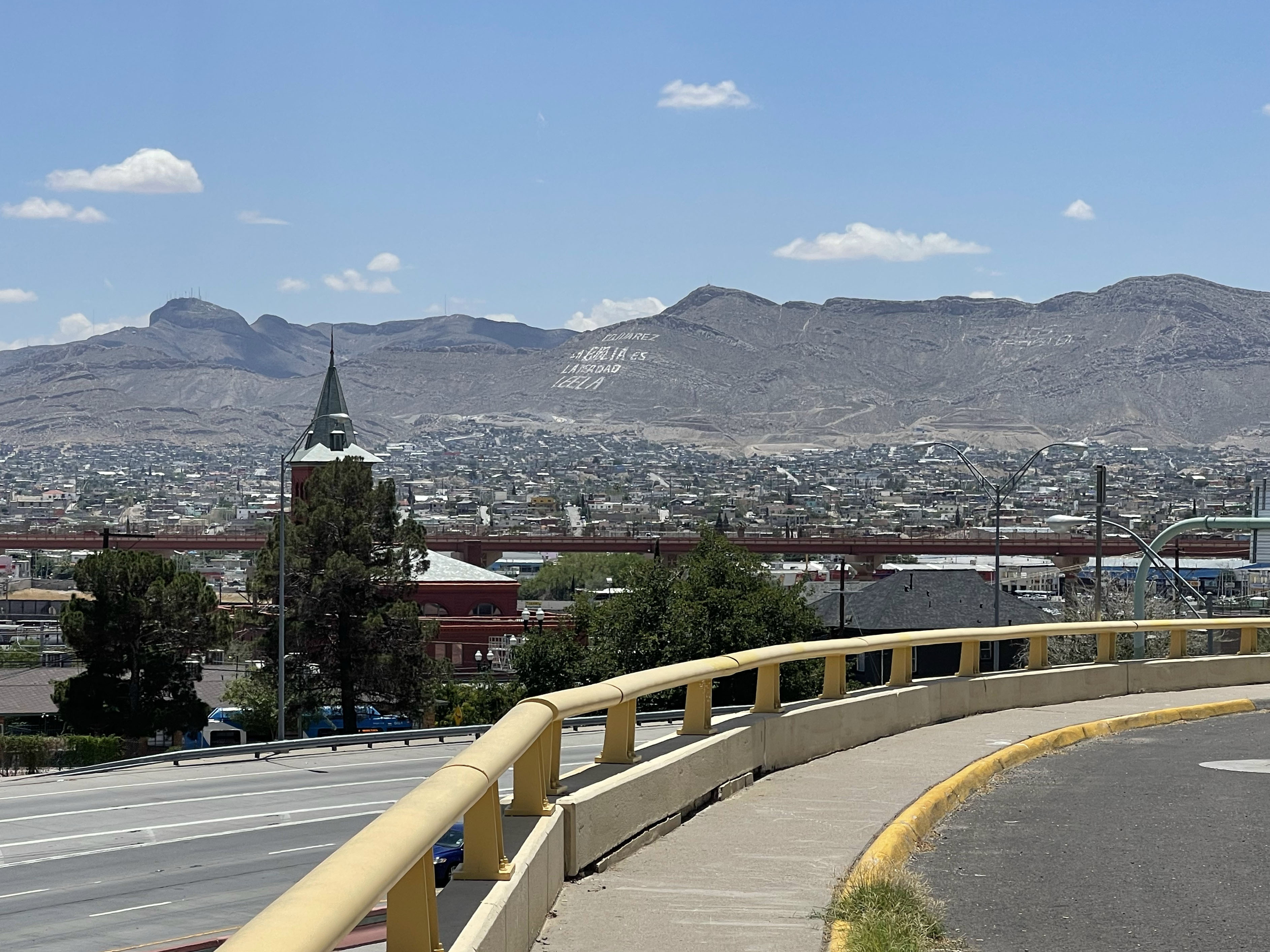
 | Day 2 – Thu, 6/30 @ 12:33AM El Paso, TX to Van Horn, TX via Mexico 136.5 mi – 2,326 ft – 11h 5m – I thought I was finished adventuring. |
 | Day 3 – Thu, 6/30 @ 11:18PM Van Horn, TX to Sanderson, TX 185.2 mi – 2,877 ft – 14h 12m – There are a lot of stars in the Milky Way. |
 | Day 4 – Sat, 7/2 @ 2:29AM Sanderson, TX to Del Rio, TX 122.0 mi – 3,478 ft – 10h 40m – Texas is hot. |
 | Day 5 – Sat, 7/2 @ 11:39PM Del Rio, TX to Dilley, TX via Uvalde 130.6 mi – 2,011 ft – 10h 20m – UVALDE ELEMENTARY SCHOOL |
 | Day 6 – Sun, 7/3 @ 10:26PM Dilley, TX to Victoria, TX 168.4 mi – 3,911 ft – 13h 27m – Riding myself back into humidity in East Texas |
 | Day 7 – Mon, 7/4 @ 10:26PM Victoria, TX to Baytown, TX via Santa Fe 180.3 mi – 823 ft – 15h 32m – SANTA FE HIGH SCHOOL |
 | Day 8 – Tue, 7/5 @ 11:57PM Baytown, TX to Westlake, LA 146.1 mi – 883 ft – 10h 21m – Finishing crossing Texas 1,044 mi in 7 days. |
 | Day 9 – Wed, 7/6 @ 11:54PM Westlake, LA to Baton Rouge, LA 153.0 mi – 1,142 ft – 10h 39m – I saw gators! From grizzlies to gators… |
 | 10 – Fri, 7/8 @ 5:32PM Birmingham, AL to Hoover, AL 15.8 mi – 1,204 ft – 1h 42m – I climbed more on this ride than yesterday’s. |
| Totals – 1,362 mi – 20,220 ft – 9 days elapsed |
Even more pics are available on the pickuta albums I created for the race and the ride home. Click on the links/screenshots to open the albums in a new tab. Click the triple bars (hamburger menu) next to the album title on the page that opens to see the pics and turn on/off the satellite tracking markers.

Leave a Reply