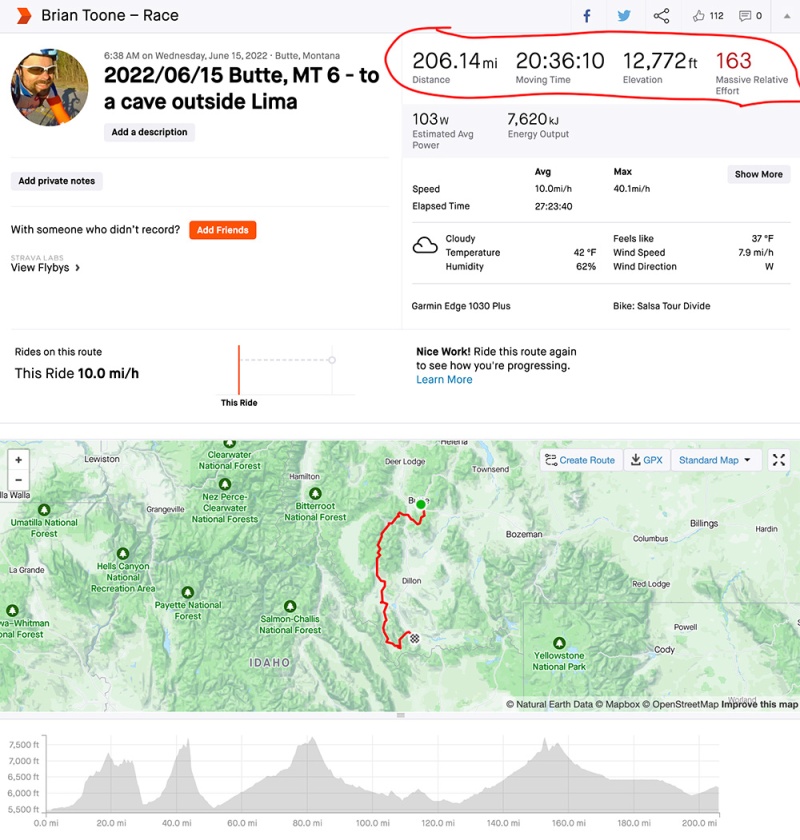
Note that the “cave” was really just a deep recession in a cliff, but it was enough to get me out of the steady wind that made the 30 degF temps feel that much colder. Also, note that I fell asleep in less than a minute after getting settled and even with a down blanket and all my clothes on I woke up shivering a couple times. How sleepy was I? Well, the entire race I was vigilant keeping all my electronic devices charged .I was so sleepy that I didn’t remember to stop my Garmin (hence the chart below), let alone plug in any devices to charge in my external battery pack.

How I ended up in a cave
It started out cold yet again, but this time it was bright and sunny leaving Butte on lots of paved bike paths, including one that went by an outdoor speed skating oval. Eventually, I turned and started climbing up a gravel road. Pretty high up on the mountain (Fleecer), I ran into a guy using an ATV to haul logs to his truck. Nearby, a woman was walking her dogs who came running up as I crawled slowly up the climb. It was a great chance to stop, hold out my hand, and let the dogs come sniff it. They seemed friendly but the lady called them back over and I started crawling up the climb again when the ATV came flying by me hauling a log (it was a pretty wide gravel road).
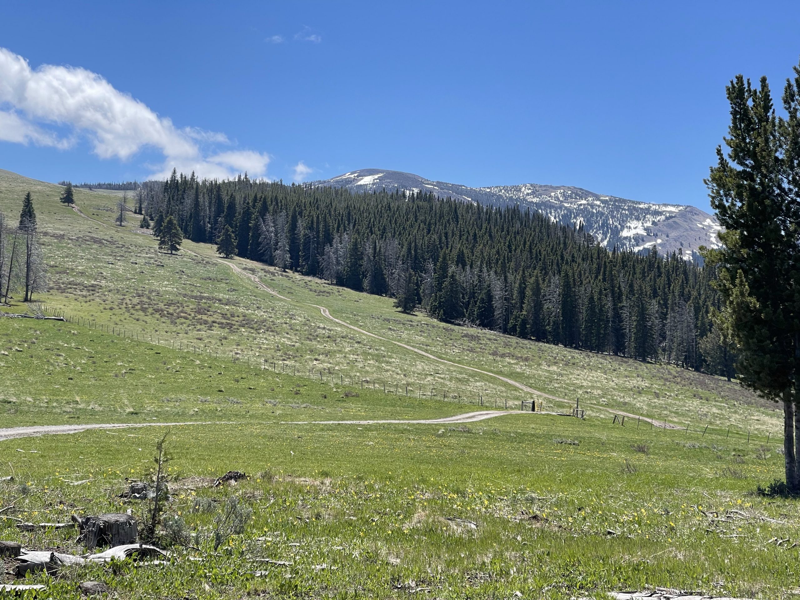
This whole gravel/dirt part of the climb had been sheltered from the view, but after making a left turn onto some double-track I could see how high up the climb had taken me see the approaching steep double-track. I had heard about Fleecer Ridge having tricky double-track, so I just assume it was this steep section of the climb shown below (left). As I would soon find out, though, Fleecer Ridge is infamous for its practically vertical descent after reaching the top of the pass (sorta pictured on the right, but not really, just imagine riding past the end of that grass and then having the mountain turn sideways at 20% average slope but sections approaching 30+%).


Following the ridiculously steep Fleecer double track downhill was a more gradual continuation of the descent down into the Wise River valley on a nice long downhill dirt road going through an area that had a few campers and even a log cabin house or two before eventually dumping it out onto pavement near Wise River.
I didn’t take a pic, but Wise River was awesome, and the Wise River Mercantile was open for resupply. Inside they had a guest book for TD racers, and I saw Zoé signed in ahead of me and counted about 10 other names knowing that not everyone would come through here when the store was open.
After Wise River, I was on pavement for about 55 miles, which was awesome. It started out as a gradual valley climb back up into a national forest (Beaverhead-Deer Lodge). I figured it would turn to dirt, but it stayed paved all the way up the climb, which got quite steep with lots of switchbacks towards the “top”, then rolled for many miles across the “top”, before dropping down steeply on a fun, twisty descent — all paved. This descent made it look like I was descending down into a different world. It was “Grasshopper Valley”, but this was the first hint of starting to lose trees and get to more desert/plains like conditions. Up until this point, most everything had been pretty heavily forested b/c the route stayed up pretty high in the mountains, but this valley was all the way back down near 5,000′.
The grasslands were cool looking, and there were large herds of cows. It was generally downhill so I was making amazing time. The course turned left onto a busier highway and continued down even more steeply but with a few short steep climbs interspersed before turning onto a dirt road. It was at this turn that I caught up to and passed eventual 10th place finisher, Daniel Connell. The next section was washboarded rolling dirt for about 10 miles before hitting pavement again outside the next small town, which I had scoped out as having a restaurant that was closing at 6:30pm. I was a couple hours ahead of that, but the town was so tiny that I was really doubting whether there would be an actual restaurant there.
The restaurant, however, was a couple miles off course but I didn’t want to try to cross the next long stretch to Lima (about 70 miles) without resupply. As it turns out, I totally didn’t need to stop because I still had tons of water left b/c of how cold it got. Still, it was great to stop at the saloon. As I rolled up, I could see a table set out for TD racers, and I saw someone standing there so I asked if they were open. She said “no, we busted a water pipe so we are closed, but come on in anyway” (or something along those lines). Inside were two northbounders stopping for the night at the attached lodge.
I made some peanut butter / jelly sandwiches and then danced around the mosquitos back outside as I resupplied and added up my total to put in the money jar. It was great, it was perfect, for what would be a long night. This was another section of the course that I had not researched much other than to know it was about 70 miles to Lima where I planned to spend the night. I didn’t know anything about “Old Bannack Rd” which can be awful with peanut butter mud. Thankfully, though, none of the storms had hit this area recently, and Old Bannack Rd was as hard as pavement. I didn’t know to even be concerned about mud and was lucky not to run into it.

I also didn’t know that it is essentially a 25 mile long gradual climb only kicking up steeply towards the end followed by a similarly gradual descent. The sun was setting as I started the long gradual climb, followed by a nice moonrise, and so many stars. The temperature was dropping from the mid 60s right on through the 50s and then continuing on down through the 40s bottoming out at 34 degF by the top of the climb.
Since it was a climb, it didn’t feel too cold as long as I kept moving. But fairly quickly I started to get sleepy. After a few hours of climbing, I was sleepy enough and going slow enough that I decided it would be more efficient to just lay down right there on the side of the road for a 20 minute nap, but I wasn’t able to fall asleep because I got very cold very quickly with it still being a bit windy.
My unsuccessful effort to sleep on the side of the road was enough to wake me up and get going again. Across the top, though, I knew I was not going to make it to Lima and should look for any kind of shelter for another short nap. That’s when I noticed a recessed part of the cliff and decided that it would be out of the wind enough and would be my best shot at actually falling asleep. I was wondering about snakes and scorpions since it had started to feel more and more like a desert. But I also realized that it was probably too cold for anything to be out and about … but what if they could detect my body heat and crawl up towards me? I was too sleepy and too cold to care, leading to the 1 hour and 45 minute nap at the top of this post.


Maps and data


Pickuta photo album
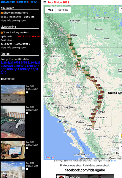
See even more pics from the entire race along with the exact time/location where each was taken on the tracking website I created called pickuta.com. If you are on a phone or small screen web browser, click the “hamburger” triple bar icon in the upper left to slide out the photos and turn on/off the tracking markers: https://pickuta.com/album/258
Leave a Reply