“Hi Brian, all I need is to see your passport,” said the US border patrol agent as I rolled up ahead of Theo. I dug in my backpack not registering that he already knew my name until I showed it to him and he wished me “good luck”. As I pulled away, I realized he must have been following trackleaders to know which riders were coming and match them to their passports. The entire crossing took less than a minute, but then I proceeded to ride 2 miles off course with Theo Kelsey, the Canadian from Toronto who had just caught up to me on the descent after the third pass, who also made it through the border crossing in under a minute. We both realized eventually that we were off course and supposed to turn immediately after the border patrol station instead of staying on the main road!
But before all that, there was lots and lots of rain intermixed with snow hike-a-bike sometimes in the rain and sometimes dry. I left Fernie before sunrise in a light steady rain enjoying as many miles of pavement as possible before the route turned into a nice rideable gravel before it turned again into a rougher sometimes muddier gravel and started to climb a bit more steeply for a while. During this section I passed Andrew at the spot he had camped as he was packing up to head out. Even though it was still raining off and on, I was starting to get hot so I stopped and chatted with him for a minute as I took off my outer layer rain vest before proceeding up the climb. So it’s interesting that stopping at the lodge still saw me gaining time (10 minutes or so) on him even though he had been able to ride farther into the night. The downside though is the money you are spending for such a short stay – I only slept for three hours and was stopped for 5 hours by the time you do all the things you gotta do to get checked in, showered, electronics plugged in, and then taking absolutely forever to wake up and reverse the process getting everything packed again. I am putting that in bold because one of the things I want to figure out for next time I do the race is making that decision about whether to take a tarp/tent with me and also even if I have one whether it makes sense to stop at a motel/lodge/toilet instead, sometimes.
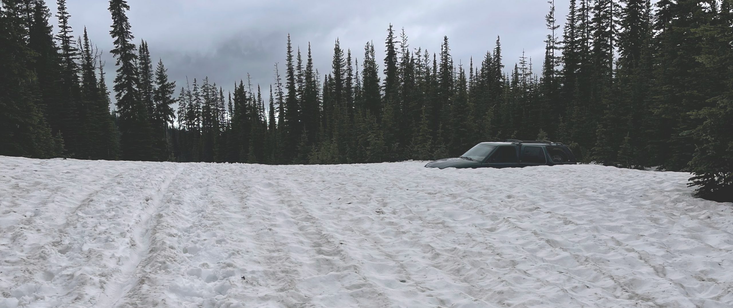
At the top of that first climb was a little bit of snow, but mostly just a little bit of mud and gravel. The next climb would have quite a bit more snow with a bit more hike-a-bike even though it was the same elevation. It still was nothing like the last pass, though, which had the most snow hike-a-bike … including a lot of deep post-holing right by an SUV that was buried up to the hood in snow.


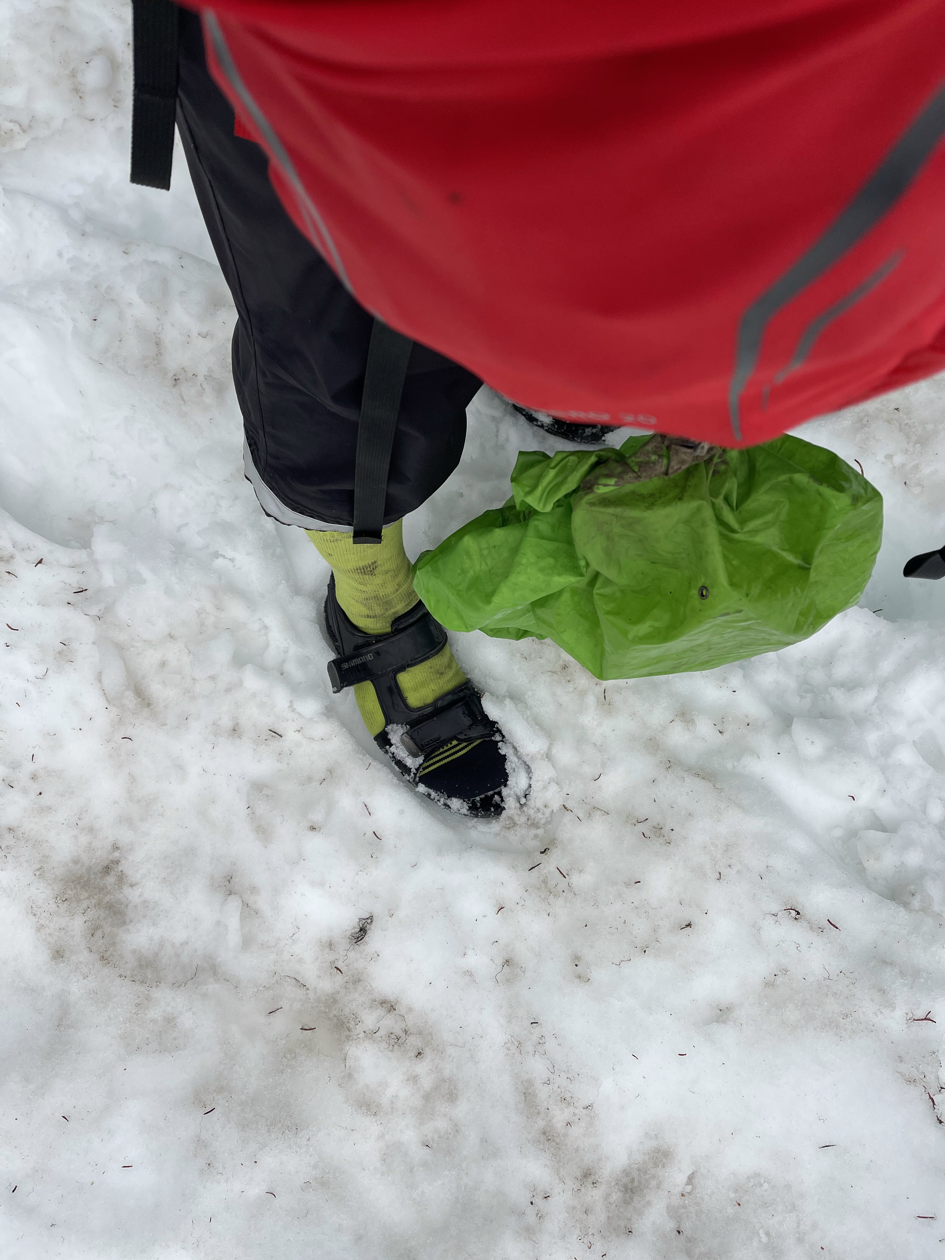
Before the snow SUV was the infamous wall at about mile 91. I’ve zoomed in on the maps above, but here’s a rough idea of how it went … first, it caught me by surprise because the route was nice wide gravel and then my GPS was telling me to turn right. I could barely even see the trail entrance, but dove down into the singletrack before having to walk almost immediately. There were sections that were rideable but most of it was just flooded. I gave up trying to keep my sandals/socks dry and just started riding through the flooded trail. The singletrack went close to a large river in a few places, and the wall itself is essentially a climb up a bluff next to the river. One particularly steep slope before the wall had a huge tree down in the middle that required quite a bit of creativity to get over. Then the “wall” itself was quite muddy but a tad bit easier than the trees. No way to scale it, though, without clogging sandal with mud. I made it and was passed by Andrew through here and Tim Tait who I would ride with a bunch the next day. Andrew passed me in the singletrack which he was able to ride better. Tim passed me after the crazy tree navigation with him arriving right as I was finishing the last balancing act to get over. I mentioned “I’m not sure it’s the best strategy but there is one way to do it pointing at how I had set my bike on top of the tree and balanced it before climbing up and around and retrieving the bike on the other side”. He must have figured it out pretty quick because it wasn’t too far up the climb away from the river that he caught back up to me and passed me. I would sleep less than Tim overnight and catch him early the next day as he was waiting for a grizzly bear. More on that tomorrow…
Hot and cold … it was amazing to me to be so hot from the exertion and yet at the same time to have feet and sometimes hands that were so cold. Thankfully, after that last pass, the sun broke through the clouds with an awesome sunset view of the valley far, far, below which meant pavement and crossing back home to the USA. It was a fast, good dirt 4,000′ descent which meant I didn’t stop to take any pics at all until after the border crossing. It was during this descent that Theo caught up to me.
I had passed him earlier in the day (but not really met him) when he was changing a flat tire where a broken spoke had poked a hole through the rim tape. I felt really bad for him because it was raining hard and to have a problem with rim tape due to broken spoke causing a flat just seemed like a lot of problems so early in the race that would have been very, very disheartening for me. It was also at a completely overgrown bushwhacking part of the race that involved quite a bit of tree navigation through thick vegetation scrambling down and then back up the “road” a few times.
That was fairly early in the day, but it still caught me by surprise when he caught back up to me later. It was awesome though to meet and get a chance to talk to Theo and cross the border into the USA together. This was my first time using a land border to cross back into the USA and as mentioned at the top of this post, it couldn’t have gone any faster or better. In fact, my border crossing back into the USA from Mexico about 3000 miles later took a good solid 20 minutes even though I was the only person there at the mostly deserted crossing 60 miles away from El Paso.
Once Theo and I got back on course we talked about our plans for the day with both of us not wanting to tackle the next snowy passes at night including the Red Meadow pass which we both knew had reports of a very low snow level and tons of snow. Theo had a camping setup, though, so he was just going to ride on and find a good place to camp. I thought about doing that, but I would need to find a toilet or some sort of covering given how much rain we had had and the propensity for storms to move in at any time including at night.
Riding the Tour Divide without shelter
Sofiane, winner of this year’s race, also did the entire race without any kind of shelter (i.e., tarp or tent). And that has been the case for many of the past winners and top finishers. So my thought process ahead of time in NOT taking any kind of shelter is that I’d be able to find shelter or just sleep for a few minutes on the trail itself if necessary and then keep riding until I found shelter. I have slept out in the open many crazy places over the years, so that didn’t bother me. Of course, it was always dry or I was able to find some sort of cover. I didn’t realize or account for the snowy/rainy conditions of the Tour Divide, which were extra rainy and extra snowy this year, and long stretches of the course (particularly later in the race) that had no shelter whatsoever anywhere. In such conditions, sometimes the trail might be covered in snow for many miles or it could be raining or storming at the point where I got sleepy. This meant that I was taking a risk any time I was bypassing a known spot where I could stop with shelter to try to make it farther to the point where it made more sense to stop from a riding / sleep standpoint. For this reason, I often had to stop much earlier than I would have liked (including this day at just 120 miles of riding).
But back to this day, I said good-bye to Theo as he was riding faster than me and I had already decided from our conversation that I would be stopping in Eureka and sleeping there and then setting out around midnight to make up for yet another short day. There were a couple motels in town so I asked at the gas station if there was one he’d recommend, and it turns out that the gas station was the check-in desk for the motel right next door. So he started the check-in process and I was amazed at the all-in-one nature of the stop: resupply and lodging. This turned out to be the case for many lodges along the entire route – a small motel would be attached to the gas station itself, which doubled as the check-in desk.
Off to bed quickly so I could start as early as possible the next day, but more on that tomorrow…


Maps and Data


Pickuta photo album
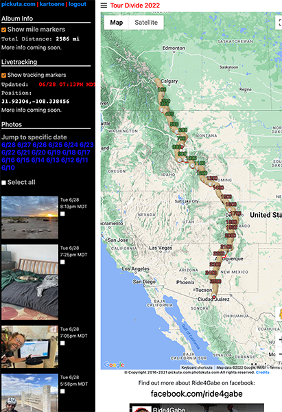
See even more pics from the entire race along with the exact time/location where each was taken on the tracking website I created called pickuta.com. If you are on a phone or small screen web browser, click the “hamburger” triple bar icon in the upper left to slide out the photos and turn on/off the tracking markers: https://pickuta.com/album/258
Leave a Reply