
I started this post in February of this year right after what turned out to be a ridiculously cold ride in Mississippi to finish off the last counties I needed to have ridden in all the counties in the state. The ride started out cold in the mid 20s for nearly the first 100 miles of the 265 mile ride, warmed up a good bit into the 50s with sun during the day, but late in the day it started to pour down rain, and by the end the temp had dropped back down into the 30s with hard rain.
I was so cold. I am writing this from Northern Minnesota where I will be riding in negative temps tomorrow, but I still shiver from how cold it was finishing that ride in the 30s. The thing I remember vividly 10 months later is standing next to my car when I finally made it back and simply unable to make my hands work to try to get my bike back into the car and then to get into the car myself. I just stood there in the pouring rain wondering for a few seconds not sure what I could do … and I was so cold – did I mention that already?!?!
What does that have to do with Florida? Well, almost exactly a week ago today, I headed out on a 319 mile ride to cover the remaining counties in South Florida that I needed to have ridden in all the counties in Florida. When I opened up the computer to write up a blog about that ride, I noticed in my drafts folder that I had titled and written one sentence about finishing up all the counties in Mississippi.
This post is still mainly going to be about my Florida adventure, but since it also involves completing all the counties in the state, I thought I’d include a short blurb about that ride in Mississippi earlier this year.

One other note about the Mississippi ride is that it was awesome (and challenging). Awesome because it involved some really cool roads, trails, and climbs, a couple universities, and a wide variety of roads (and not roads). A cool thing about these rides is experiencing the “reality on the ground” as I plan them all out by mapping them first (which is half the fun for me) and then get to see what it’s really like … is the bridge really still there? How old was the satellite imagery?
The picture below is from the bike trail leaving the University of Mississippi in Oxford. There were some cool mountain bike trails that took advantage of all the hills coming up to the railroad grade. Looked pretty fun, but I wasn’t going to be able to do them while attempting to charge my dying Garmin.

Florida Counties
Now let’s get back to Florida. Last December, I did the Cross Florida ITT and then rode back to the start covering about 1000 miles and LOTS of central Florida counties. On that ride, I had intended to drop down and ride just far enough south to catch the Miami and Key West counties (you don’t have to go down to Key West to ride in its county). But the CFITT took nearly a day longer than I had anticipated (and it was awesome!) so I had to cut out a day of riding on the way back. Also, I literally “missed” a county on the way down due to a route planning error. I didn’t realize there was another county (Florida’s fourth smallest – Seminole County) in one of the blank spots on my map so I only routed myself through one of the two counties there.
In any case, to hit those Southern Florida counties, I was going to have drive right by the Northern and Central Florida counties I was missing … so I ended up doing three separate rides in one crazy long day (about 40 hours long). Here’s how that played out.
I left home at about 1am to drive 675 miles down to the start. Along the way, I stopped just across the border in White Springs, Florida to ride in two counties I was missing, which were separated by a county I had already ridden in. So that ride ended up being almost 50 miles long, starting out in one of the two missing counties, crossing the county I had already ridden in, and then turning around shortly after reaching the other missing county.


White Springs turned out to be a pretty cool little place where you could ride right down to the historic springs, which used to attract people from all over the east coast down to bathe in the springs. Now, there are alligator warning signs and people don’t swim in the springs any more (at least I don’t think they do).
I finished that ride by about 11am and took off again south towards Orlando. I routed myself to the University of Central Florida, which borders the county I was missing, and scoped out a 10 mile loop that would take me across the county border and then back around to the start. This turned out to be great, even though UCF was having graduation. Thankfully it was during my ride so there wasn’t too much traffic since I started after graduation started and finished before it finished. During the ride, I stumbled upon the Econ River Wilderness Area. Most wilderness areas ban bikes, but this one had a bikes permitted sign and some fun sandy trails to ride down to the river.


Afterwards, I still had a ways to go, and headed out of Orlando at rush hour. I had only slept for about three hours before starting the 675 mile drive at 1am, so I was starting to get sleepy. I stopped at a Waffle House, had some food and coffee and bought “breakfast” for when I woke up after a short nap at Lake Okeechobee. It got pretty rural pretty quick as I turned away from the coast and headed inland to the lake.
I found the spot I had scouted out via satellite, and it was the perfect spot alongside Lake Okeechobee … except apparently it was also a “hang-out” spot for teens/young adults. Many cars drove by after I first parked and was starting to get everything ready to head out after a nap. Most of them drove up onto the levee (pretty sure they weren’t supposed to do that), but I thought I looked conspicuous there and knew that I wouldn’t be able to sleep with all the noise and headlights. So I moved my car out from under the bridge and to the other side near the Sanchez Memorial trailhead. This was perfect, because the embankment supporting the bridge blocked the headlights from the cars that presumably continued to come down. I was only going to sleep for a few hours and get started again, which is exactly what I did.
There were lots of mosquitoes outside the car so I got as much as I could ready inside the car, and only stepped out briefly to mount things on my bike, and then got back into the car to sleep in the back. I slept fitfully until I found a comfortable position and orientation and got a couple hours of sleep. Still, I woke up without an alarm after less than three hours after arriving and was on my way before midnight setting out on a 319 mile ride taking me through the Everglades.
And it was awesome.


I started out under a nearly full moon along the Lake Okeechobee trail. This was technically one of the unfinished sections, but there is a double track road that circles the entire lake. Sections are being converted to paved trail, and the other sections are hit or miss whether they are “open” to the public or not. This section didn’t have any no trespassing signs, so I rode around the gate on a well established path and continued on the rough double track for about 15 miles before dropping down off the levee to start heading more directly south towards Fort Lauderdale and Miami.
I had routed myself on a very busy state highway knowing that it would be middle of the night. Still, I had used satellite to trace my path on what I thought was a sidewalk, but turned out to be a separate gravel road on the opposite side of an irrigation canal with limited bridges. After riding on the gravel for a bunch of miles, I decided to just hop on the mostly deserted (except for trucks) highway. It had a nice, huge shoulder and was quite a bit faster.
The first big surprise for me was rain … there was no forecast for rain, but I guess it is humid enough this far south that there is always a chance of rain. I only got caught by a little of it and basically rode out of it (or the storm went north of me). It was a cool looking storm cloud in the moonlight, though. I was a little bit chilly (about 63 degF and wet) when I stopped at a gas station/truck stop about 75 miles into my ride.
I knew that this would be the last place to stop for at least another 60 miles, so even though I didn’t technically need to stop yet, I was worried about having enough to drink to cover another 60 miles. So I stopped and got some gatorade and food and was packing up the bike when a trucker asked if I was the guy he had passed (I was passed by many trucks). I said “yep” and he said that I had a good light and he could see me from a long ways away. He said that it didn’t matter though if a drunk person hit you. I thanked him for the warning, and I do think it’s interesting how people like to warn me as if I am not aware of the millions of dangers in all shapes, sizes, and backgrounds.
Riding through the Everglades
The next 75 miles of this ride were by far my favorite. Immediately after leaving the gas station, I crossed the highway into an RV park at the edge of the Everglades Wildlife Management Area. Out the back of the RV park is a nearly 30 mile long levee that connects down to the only road that connects Miami and Naples together in southern Florida.


The entrance to the levee had a caution sign that the levee was closed at the other end, which I knew was nearly 30 miles away, so I paused for probably a good 1-2 minutes weighing the risk of getting all the way down there and having to ride all the way back to this spot if there really was no way to get across. I also knew that riding 30 miles through the Everglades on a levee was probably a once in a lifetime experience, so I steeled myself with the thought that if this is 320 mile ride turned into a 390-400 mile ride, it wouldn’t be the end of the world. Plus I would get to ride through the everglades twice.
As it turned out, the construction at the far end looked completely finished, although there was one section a few miles from the end where they were working on the levee itself. No problem to get through on my bike, but the sand itself was quite loose on the levee where all the construction vehicles had been driving for a short distance. Having started out before sunrise and finishing the levee after sunrise … it was a long levee! Along the way I got to see a cool moonset and beautiful sunrise over the swamp.


When I was planning out this route, I noticed at the end of the levee trail was a marker for the Valujet Flight 592 memorial (the airplane that crashed into the swamp near here). So I had been looking forward to seeing that in person, and was delighted to find that it was indeed right next to the levee.


I hopped on the busy highway (the only road connecting Miami to Naples through this part of the Everglades). I had scouted out places to stop for food, and I noticed many airboats offering swamp tours and one gas station. I wasn’t sure of my exact timing here, but figured I’d find something. It ended up being the gas station in the Micosukee Reservation. Masks were required inside the store and I had unfortunately left mine in the car when I was moving things around to get ready to ride. The clerk gave me one, though, when I told her I had left mine back at the car.
My next stop after this was going to be another 75 miles, and it was supposed to get well up into the 80s, so I loaded up with a lot of gatorade and chatted with a county sheriff who was waiting in the checkout line about the route I had planned (Loop Rd). He mentioned that it would be tough on a road bike, but fine on a mountain bike. I told him my whole route and he asked how many days, and I said “just the one” and he was quite surprised, and said that would take him a week.
No alligators at all in the Everglades WMA (perhaps they were all still underwater and out of sight) but this next section on Loop Rd and even back on the main highway had probably close to 100 alligators. The Loop Rd ones were the best because the sun was still low enough in the sky to really let you see down into the water. This was also the section with the most birds … so many birds. Lots of egrets and herons that make the ones back home seem like miniature versions of the real thing. Plus there was an extremely loud black and gold hair smaller heron here that sounded like I would imagine a pterodactyl would sound.


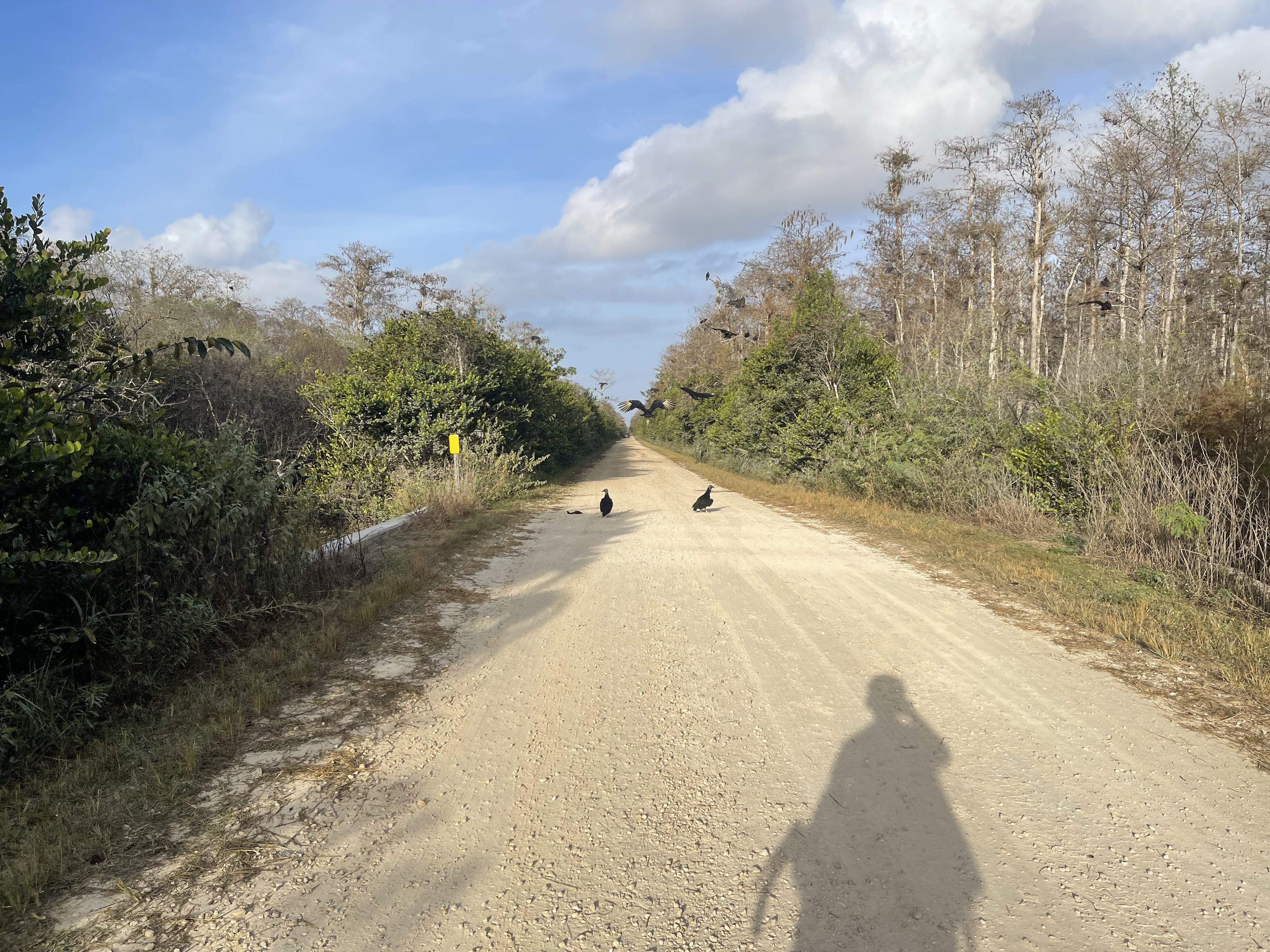

And lots of vultures. Almost every bridge had both a fish on it and a pack of vultures. My only thoughts on the fish is that they were dropped by a bird? I was wondering why they seemed to happen mainly at bridges, though. Gators also liked the bridges, so maybe there are more fish there and more likely for a bird to drop a fish as it was taking off if it got spooked.
Somewhere near the middle of Loop Rd was a trailhead with a warning about panthers. I wish I had stopped to take a pic of it, but I figured there would be more warning signs like that. But I never did see another one of those signs. I did see lots of panther crossing signs, though, along with miles and miles of a very tall (10+ ft) barbed wire fence on both sides of the road through the Panther National Wildlife Refuge.
Before making it to the official Panther NWR, I took a right turn onto a dirt road and detoured through the Big Cypress National Preserve to get off the busy highway. It was fun (and surprising) to see all the birds in the canal/swamp adjacent to the busy highway for many miles. Still, it’s not fun to get passed by cars going 80+ mph. Most were averaging about 65-75mph, but there were multiple 80+ cars and even one car going 121mph. It was insanely fast, and I had the speed right there on my radar.
The two biggest alligators I saw were here through the Big Cypress preserve along with warning signs about feeding alligators. They also had huge golf cart buggy swamp tours and lots of headwind. It was a tough section. The headwind helped with the heat, though, because it was well into the 80s by this point and hard riding through the sandy roads with deep sand in places.


After the swamp, I headed up through the Panther NWR and back through all the new counties I needed on my way back up to my car alongside Lake Okeechobee.


I had intended to ride along the lake, but I couldn’t find the entrance on the far side of a lock that I had to come down off the trail to cross. I was tired and ready to be done, so I thought I would just take the highway … big mistake … it was dark, busy, and no shoulder.
There was an old version of the highway that I should have hopped onto, but I was worried that it wouldn’t go through. The Garmin 1030 does not scroll well when you are far into a long route. I should have used Google maps to scout it out, but there is also the challenge of making quick decisions while riding and not wanting to stop. All of that led to me just staying on the main highway (and regretting it).
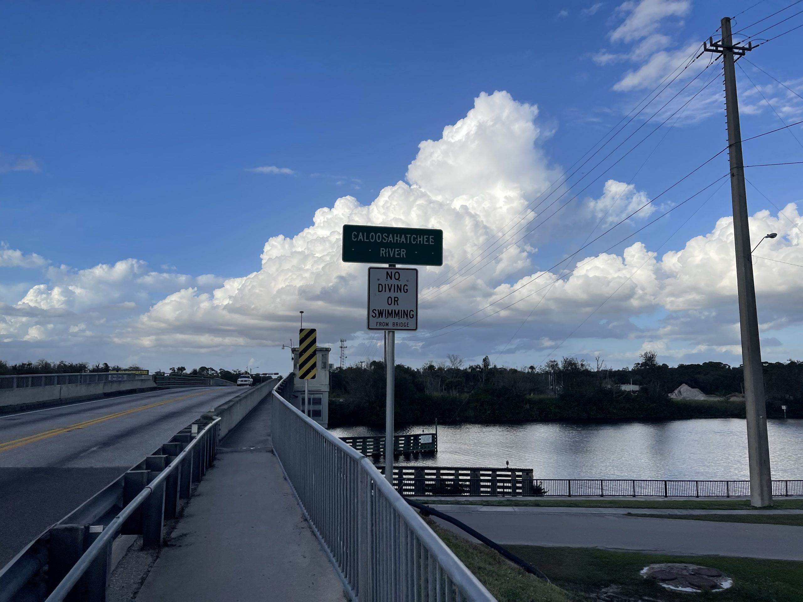
Eventually, though, I made it to Belle Meade and traffic died down a bit after I got through that town. One last stretch to go, and I made it back to the bridge I had parked under 319 miles earlier having now finished riding in all of the counties in Florida.
Not quite finished, though, because I still had to drive 675 miles home before we were driving almost 1250 miles to near the Canadian border in Minnesota (Lusten, MN) for Christmas vacation with Kristine’s family. I left Okeechobee pretty wide awake, but knew that I would be sleepy soon. I pulled over at the first gas station I saw once I got sleepy and slept in the driver’s seat for over four hours. This surprised me, so when I woke up, I was definitely wide awake and made it back home by about noon on Sunday. Grant total was 1300 miles of driving with 380 miles of biking from Friday morning at 1am until Sunday at noon over a span of 59 hours!
Ride stats and links
| Date | Ride Title and Strava Link | Dist | Time | Temp |
| 2021-02-06 | all of Mississippi complete! | 265.3 mi | 18:28 | 37 degF |
| 2021-12-17 | the last two northern FL counties | 49.3 mi | 3:09 | 66 degF |
| 2021-12-17 | university of central florida | 10.7 mi | 0:51 | 81 degF |
| 2021-12-17 | finishing florida | 319.1 mi | 22:30 | 73 degF |
| 2021-12-26 | failed eagle mtn summit attempt, too cold | 35.6 mi | 4:02 | 3 degF |
| 2021-12-27 | st croix stillwater adventure | 25.6 mi | 3:23 | 21 degF |
| 2021-12-28 | ride back to the house in winter weather | 43.4 mi | 4:33 | 18 degF |
As I write this up, we are nearing the end of our vacation in the winter wonderland and about to head back south where I am hoping to finish up my goal of 20,000 miles for the year and also the Festive 500 with a 500km ride on New Year’s Eve … hoping to start by about midnight so I can finish relatively early in the evening … but that will be the day after driving home 1100 miles from here in the Twin Cities … so we shall see … always an adventure!

45 mile ride from St Paul, MN to Bayport, MN in the cold sleet, snow, and rain (?) at 18 degF.
Leave a Reply