Photos! I have a ton of them from the trip. You can quickly scroll through the thumbnails and see some of my captions on my pickuta website by clicking on the link below:
https://pickuta.com/album/226
BACKGROUND – RIDE 4 GABE v1, v2, v3, and v4
I met Gabe Griffin and his family back in 2014 during the preparation for the inaugural Ride4Gabe when my soon-to-be friends Wes Bates and Michael Staley rode their bikes from Bend, Oregon to Mobile, Alabama raising funds and awareness of how Duchenne muscular dystrophy affects boys with this genetic disorder and the impact on their families.
Ever since then, I have wanted to be involved in advancing the mission of H4G and to stay connected to Gabe and his family. In 2014, I rode a long stretch with Michael and Wes as they traversed through Alabama. Then in 2016, along with my friend Demetrious White, I rode the entire length of Alabama down to the finish in Mobile as Michael, Wes, and another friend, Payne Griffin, rode from Maine to Mobile on Ride4Gabe 2.0.
Ride4Gabe 3.0 was my third place finish in the Race Across America in 2017 where Gabe and his family followed me across the country as I raced my bike from Oceanside, California to Annapolis, Maryland.
Ride4Gabe 4.0 was me, Demetrious White, and Michael Staley riding from Birmingham, Alabama to the top of Pikes Peak in Colorado in 2019. This was an amazing experience and was amazing to have Gabe follow us to the top of Pike’s Peak.
Then coronavirus happened in 2020 and we postponed Ride4Gabe 5.0 until this summer (2021), but coronavirus dragged on into 2021 and we decided to do something different this year which timed perfectly with our family plans for the summer.
The Tour Divide and Fort Lewis Cycling
I have had my eyes set on the Tour Divide as the next long ultra race I’d like to tackle, but with the Canadian border still closed and no real pressure to complete that race ASAP, I decided it made more sense to use this summer as another chance to train for the race with a multi day solo bikepacking adventure.
Also, with my son attending a cycling camp at Fort Lewis College here in Durango, Colorado, I could ride out and meet the rest of the family before they left to return back home so I could catch a ride back with them. The camp is going well with Josiah texting us after his first ride that it was the best ride of his life. The rest of the week has gone really well, too.
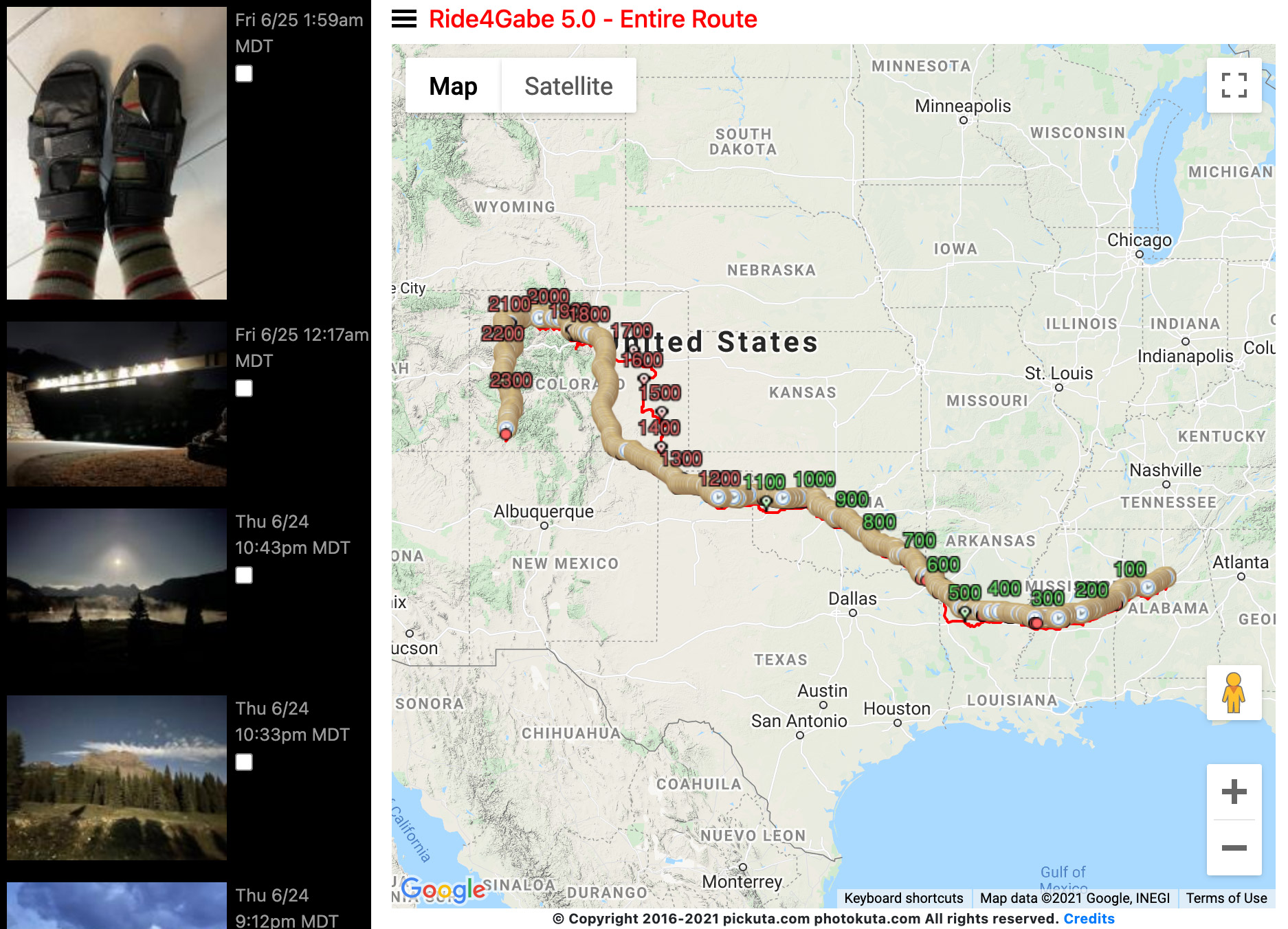
The Data – day by day ride stats
| START DATE/TIME | DISTANCE | HH:MM | Speed | Heartrate | Cadence | Climbing | Avg/Min/Max (degF) |
| Mon,6/14,12:06am | 274.5 miles | 19:55 | 14.5mph | 124bpm | 72rpm | 10896ft | 77/64/100 |
| Tues,6/15,1:57am | 173.2 miles | 14:20 | 13.7mph | 106bpm | 64rpm | 4068ft | 83/68/104 |
| Tues,6/15,9:53pm | 279.9 miles | 24:30 | 12.8mph | 103bpm | 60rpm | 6791ft | 82/66/104 |
| Thurs,6/17,5:19am | 163.4 miles | 14:43 | 12.4mph | 96bpm | 57rpm | 5951ft | 90/68/102 |
| Fri,6/18,2:01am | 132.7 miles | 12:32 | 12.4mph | 93bpm | 57rpm | 5600ft | 82/64/108 |
| Fri,6/18,9:25pm | 231.8 miles | 21:17 | 12.4mph | 94bpm | 57rpm | 7182ft | 83/64/117 |
| Sun,6/20,3:46am | 105.5 miles | 10:40 | 10.8mph | 94bpm | 58rpm | 4160ft | 78/59/99 |
| Sun,6/20,9:10pm | 242.9 miles | 22:16 | 11.8mph | 95bpm | 57rpm | 9708ft | 60/48/77 |
| Tues,6/22,7:41am | 81.5 miles | 9:07 | 9.8mph | 102bpm | 62rpm | 7595ft | 81/66/93 |
| Tues,6/22,11:40pm | 199.2 miles | 18:36 | 11.9mph | 98bpm | 62rpm | 10512ft | 63/28/84 |
| Thurs,6/24,3:02am | 214.7 miles | 22:47 | 11.2mph | 100bpm | 62rpm | 16991ft | 58/37/90 |
| Totals: 11 days | 2099.7miles | 190:48 | 11.0mph | 100.8bpm | 60.8rpm | 89454ft | 75/28/117 |
More data – total stop time between rides (74:56), average daily stoppage (6:49)
| CITY | START | FINISH | CITY | STOP (HH:MM) |
| Hoover, AL | Mon 6/14/21 12:06 AM | Mon 6/14/21 8:01 PM | Jackson, MS | 5:55 |
| Jackson, MS | Tue 6/15/21 1:57 AM | Tue 6/15/21 4:17 PM | Arcadia, LA | 5:35 |
| Arcadia, LA | Tue 6/15/21 9:53 PM | Wed 6/16/21 10:23 PM | McGee, OK | 6:55 |
| McGee, OK | Thu 6/17/21 5:19 AM | Thu 6/17/21 8:01 PM | Tuttle, OK | 5:59 |
| Tuttle, OK | Fri 6/18/21 2:01 AM | Fri 6/18/21 2:33 PM | Cheyenne, OK | 6:51 |
| Cheyenne, OK | Fri 6/18/21 9:25 PM | Sat 6/19/21 6:42 PM | Clayton, NM | 9:03 |
| Clayton, NM | Sun 6/20/21 3:46 AM | Sun 6/20/21 2:26 PM | Trinidad, CO | 6:43 |
| Trinidad, CO | Sun 6/20/21 9:10 PM | Mon 6/21/21 7:25 PM | Golden, CO | 12:15 |
| Golden, CO | Tue 6/22/21 7:41 AM | Tue 6/22/21 4:48 PM | Granby, CO | 6:51 |
| Granby, CO | Tue 6/22/21 11:40 PM | Wed 6/23/21 6:16 PM | Rifle, CO | 8:45 |
| Rifle, CO | Thu 6/24/21 3:02 AM | Fri 6/25/21 1:49 AM | Durango, CO | N/A |
| Total Stoppage: | 74:56 (6:49 avg) |

Looking at the data, I was stopped for too long between rides when trying to set a good record pace. Sometimes that might be necessary, as one can only do so many 3 hour sleeps in a row before riding becomes quite ineffectual. The key is minimizing the stopped time not sleeping. It’s a balance, for sure, and since this was primarily a fundraising ride that I wanted to actually enjoy, I opted for longer stops rather than trying to rush myself to bed and back out the door – especially since I was seeing (and meeting) awesome people that I was staying with on the route. That being said, it’s important to note that a good run on the Tour Divide will involve much shorter stops if I want to have any hope of a 14 day finish.
Also, a huge factor in this ride was the weather. You’ve got to expect thunderstorms in the south, and I did get walloped early with one in Tuscaloosa. But then I had no rain for the rest of the week until a very cold steady rain fell on me for a few hours for 30+ miles before, during, after my ride through Pueblo, Colorado. Also, this time of year is called “monsoon season” in the southwest. And I dodged all the thunderstorms which popped up just about every day somewhere within sight while I was in Colorado — except for a couple of them on the last day. I rode through the first one, waited out the second one at a McDonald’s in Montrose, and then had to seek shelter under a picnic table on a third one after riding in it for what felt like an eternity, but was probably less than an hour.
The biggest weather surprise to me was the heat and the cold. The temperatures I saw on the ride ranged from a high of 117 degF late in the afternoon in West Texas to a low of 28 degF way up in a mountain valley at sunrise in Colorado on the next to last day. The heat was oppressive all the way up through that first day in Colorado. Then it became the cold nights/mornings that were tricky to deal with. Thankfully, my wife had told me to expect cold temps so I had brought a very warm down vest, arm warmers, leg warmers, thick wool socks, and the “Hot Hands” hand and feet warmers. This collage of pics kinda tells the temperature story from riding with no shirt in the mornings to maximize coolness until the sun got high enough in the sky to start sunburn all the way to “Hot Hands” feet warmers wedged in front of my toes to handle freezing temps on long mountain descents on the last day.

Temperature only in the 60s in this pic, but my strategy was to try to stay as cool as possible throughout the night and into the morning so that the inevitable daytime heat was manageable. 
How fun would it have been to swim across the Red River from Texas into Oklahoma … but then I’d have to swim back to get my bike! Instead, to escape the insane afternoon heat, I opted to swim under the bridge with all my clothes on to cool off for a few minutes. 
My jersey was fully unzipped in several parts of Colorado which got quite hot even at 10,000+ feet of elevation crossing Berthoud Pass. 
Riding 30-40mph down mountain descents with temps near or below freezing for many miles can be quite cold – especially if you aren’t even wearing shoes! Thankfully, I had thick wool socks and “Hot Hands” feet warmers I could wrap around my toes to act as a wind barrier in addition to extra heat.

We ride at midnight – Day 1 – Hoover, AL to Jackson, MS
[Monday, June 14th, 12:06am, 274.5 miles, 10896ft, 77 degF, 64 (min), 100 (max)]
Pete Foret and Michael Staley biked over to my house so I could roll out of town with friends at midnight. I wanted to leave at midnight so that I could finish early enough to leave super early the next day to try to finish riding as early in the afternoon/evening as possible to avoid the hottest part of the day. Even so, it was quite warm at midnight as we biked over towards Lakeshore Drive and on down towards Bessemer where they turned left to head back to Hoover and I turned right to traverse almost 2100 miles through Alabama, Mississippi, Louisiana, Arkansas, Texas, Oklahoma, Texas (again), New Mexico, and finally all the way through the mountains to Durango on the western side of Colorado.
By the time I started getting closer to Tuscaloosa, I noticed how drenched I was from sweat and decided that in the interest of a hot day ahead I should take off my jersey and just ride without a jersey to keep it from continuing to soak up sweat and dehydrate me even further. This was a great idea, but as I made my way towards Tuscaloosa, I noticed some flashes of lightning. I didn’t think anything of it because there wasn’t any real signs of rain and a quick check of the radar showed some storms north and east back towards western Birmingham. But as I got closer to Tuscaloosa, I could feel the air change, and eventually it did start to rain quite a bit all the way through sunrise well west of Tuscaloosa with lightning continuing throughout the storm. Hilariously, I just kept on riding without socks, without a shirt, through what felt like a pretty heavy cold rain … but I knew it would be getting hot later and the colder I felt now the longer I would push off dehydration later.
The rain eased up mid morning, and then the sun came out, and sure enough it got hot, quite hot. I was beginning to be worried about how dehydrated and hot I was getting when I stopped at a gas station and had cramps everywhere – including my hands.
One of the things that got me through the afternoon struggle with the heat was a surprise phone call from Gabe plus a text message, too! It was awesome to hear from Gabe and know that he knew I was pushing through the pain to help H4G! Also, the afternoon storms started to build which provided some relief from the heat with storm clouds blocking the sun for extended periods of time giving me relief from the almost 100 degF temps with it still 90+ degF in the shade! There was a big storm that formed and rolled out ahead of me near Jackson, but I came into the Shearer’s house behind it just riding through wet streets. Sometimes it pays to be slow! Shortly after I arrived, though, it downpoured really hard so I was glad to have made it there just in time. Sometimes it pays to be fast! The Shearer’s had pizza waiting for me, and it was awesome to hang out with them for a bit before turning in for a short sleep before another early start.
Heat Deviations – Day 2 – Jackson, MS to Arcadia, LA
[Tuesday, June 15th, 1:57am, 173.2miles, 4068ft, 83 degF, 68 (min), 104 (max)]
This day was supposed to include almost all of the northern Louisiana counties plus a dip down below Arcadia to the highest point in Louisiana (Driskill Mountain) and then on around it to another interesting spot about 10 miles away – the spot where Bonnie and Clyde had their fatal shootout with police. BUT, after a hilly start from Jackson to Vicksburg and a nice shuttle across the Mississippi River on I-20 provided by Joe Giambrone, pretty much the head of all things cycling in Vicksburg, I had a nice long fast stretch of Highway 80 that looked promising to get me to Shreveport … but then the sun came up and without a lot of shade I quickly deteriorated in the heat.
I started gas station hopping with quite frequent stops at gas stations to get ice and gatorade. By the time I hit Arcadia, it was pretty much unbearable. I had already eliminated my deviation north to hit some of the county lines above Hwy 80 and decided that in the interest of finishing the ride without heat exhaustion so early on, it would be better to avoid the rural stretch of roads and dirt roads taking me to Driskill Mountain. I opted to stay on Highway 80. But ironically, the bridge over I-20 was gone (they were in the process of building a new one that wasn’t even there yet). So the detour was to hop on I-20 for a couple miles and get off at the next exit. No bridges to cross, so the I-20 shoulder wasn’t bad except for a LOT of tire and road debris. Thankfully, no flats there on the side of I-20 or indeed the entire trip.
After getting back onto Hwy 80, I searched for “lodging” near Arcadia and saw that there was a Days Inn up near the interstate. So I hopped off Hwy 80 again and headed north torwards the Interstate where I saw a gas station I could get some food and drink before taking an afternoon siesta across the street at the Days Inn to escape the ridiculous heat. I was in pretty bad shape and had a hard time working the credit card machine so the clerk had to come around and help me put the card in the right way.
Since I had started so early, it was only about four in the afternoon when I got the room at the hotel. This meant I could start again the same day after a few hours, which is not only great for Eddington, but also great for maximizing the amount of night time riding.
A hard day’s night prior to another hard day – Day 3 – Arcadia, LA to McGee, OK
[Tuesday, June 15th, 9:53pm, 279.9miles, 6791ft, 82 degF, 66 (min), 104 (max)]
This ended up being the longest and hardest “day” of the trip. Hard to call it just a day since the elapsed time was 24 hours and 30 minutes from 9:53pm to 10:23pm the next night. It was also about 25 miles farther than I had anticipated with a good 10 mile chunk in the heat of the day having run out of water on an awfully hilly and just awful chunky gravel road and still not carrying around a smart water bottle to enable water filtering.
Here’s how it played out: still pretty hot (upper 70s) when I left, but it cooled off down into the 60s, which felt even cooler since I was riding without a shirt all night until well after sunrise (not wanting to risk sunburn once the sun was up high enough). I made it to Arkansas and Texas around sunrise (but on a more direct route that saw me bypassing the city of Texarkana to the south).
It was very hot by the time I made it up through Texas to the Red River on the Oklahoma border. This was the highlight of the day for me because as I approached the river (not even realizing it was the Oklahoma border), I could see a dirt road off to the side of the bridge leading straight down to the river. Without any hesitation at all and even speeding up a bit with excitement, I hit the dirt road to park my bike under the bridge in the shade and jump in the river as quickly as possible.
Still, I was careful to make sure I didn’t get everything muddy as I still had 1500 miles left to ride and didn’t want mud all over everything leading to problems later. The difference in temperature under the bridge in the shade vs the state highway I had been on previously was incredible. My garmin shows a drop of only 6 degF from 99 to 93 degF, but that felt like 20 degF difference. Plus, the water was still quite cold under the bridge so I didn’t actually swim around for more than a minute or two.
Afterwards I was thinking how awesome a place this would be to just lay down and sleep for several hours. Unfortunately, I was almost out of water and food and not the least bit tired/sleepy so I thought it would be wiser to get everything packed up and on my way again. I was only stopped for 20 minutes, but it made a huge difference in being able to finish that day without heat exhaustion.
A few miles down the road in Oklahoma I did make it to a rural gas station with an older gentleman clerk who was very nice and helped me out with extra ice and also had a litter of kittens living under the bench outside. They climbed all over me and up onto my bike even and I had to chase one down inside the store when I accidentally let it in when I went back inside to get more ice. It was another great break from the heat, albeit also only about 20 minutes long.
Afterwards, it was pretty uneventful gas station hopping with me making the unfortunate decision to skip a gas station and get one at the next city. Unfortunately, that city turned out to be basically just a crossroads without a gas station and I ended up running out of water on a very rough gravel road before hitting the next one. During this time, I decided to cut my ride short and get a hotel instead of camping at the state park which was 25 miles farther down the road.
Unfortunately, there were no rooms available at two of the motels and the third was completely closed due to covid. So I stopped at Sonic, had a nice dinner, and decided to plug away at the 25 miles to the state park where I had a “hut” reserved at the campground. The “hut” was basically a small cabin with AC and electric outlets and a mattress. It was challenging finding the office and the key, but I was Facetiming with Michael and Demetrious and Katelyn who were planning out their ride to Memphis on Friday. Great way to end a very long day.
Short day and new friends – Day 4 – McGee, OK to Tuttle, OK
[Thursday, June 17th, 5:19am, 163.4miles, 5951ft, 90 degF, 68 (min), 102 (max)]
Not surprisingly with a 5:19am start, this ended up being the hottest day of the entire trip with a 90 degF average temperature. Thankfully at one of my early stops at a Love’s truck stop, a clerk on break was talking to me and I was explaining about where I was going and how it was great except for the heat. She said, I’ve got just the thing for you. And she brought out two very thin disposable wash cloths that were absolutely perfect for filling with ice and stuffing down into the top of my jersey. The ice would very slowly melt over the next hour or sometimes two hours if there was enough shade. This really helped cool down my core body temp as that ice cold water dripped directly down my back. It may have also contributed to saddle sores later, but it was definitely worth it to get amazing relief from the oppressive heat.
This was at 10:30 in the morning with the temps already well into the 90s. It stayed hot and hilly the rest of the day. I was fascinated by the overall increase in elevation and excited to finally reach back to the highest elevations I had hit in Alabama before heading down towards the Mississippi River. Fun, constant rollers on shady smooth chip seal roads took me all the way to Tuttle after a long stretch of very busy rush hour traffic leaving Norman and Oklahoma City. Thankfully I had a massive shoulder and no problems with traffic at all.
I arrived at the address in Tuttle to find my friend Stephen Peters’ friend Isaiah greeting me and taking amazing care of everything I needed. Stephen must have prepped him ahead of time what a tired, incoherent cross country riding cyclist must need because Isaiah had it all! It was great to sit down to a meal not at a gas station or fast food restaurant and chat about everything after a nice shower before heading off to a comfy bed at 9pm. Isaiah was still up knowing that I was planning on leaving at about 1am and helped see me on my way by the time I finally got everything back together (I had unpacked everything to fix a few things that were loose and rattling) and pulled out of the driveway at 2am.
An even shorter, but harder, day – Day 5 – Tuttle, OK to Cheyenne, OK
[Friday, June 18th, 2:01am, 132.7 miles, 5600ft, 82 degF, 64 (min), 108 (max)]
I had another short day planned to try to get caught up in case I had fallen behind my schedule. This worked really well because even though the average temp was a bit cooler, the afternoon temps were scorching hot with somewhat long distances between stops.
By the time I hit Cheyenne, I knew I needed to either take an extended break in the gas station air conditioning or look for lodging. I had actually been looking forward to the Spitout campground on a lake about 20 miles farther up the road, but given how hot it was and given that there was a hotel just a few blocks from the gas station, I opted to skip the campground and take advantage of the AC and sleep for a few hours to maximize my nighttime riding across the Texas panhandle the next day.
I asked one of the checkout clerks if there was lodging nearby as I was trying to make that decision about how long to hang out in the gas station. She said there was two in town including one just a couple blocks away. A guy in the other line (the gas station was pretty busy) said he saw me on the way out and on the way back in on the long dirt road I had been on (he had been checking on oil wells I think) and he said he was surprised how much progress I had made between when he saw me both times. It was indeed a hilly, rough, and HOT road, but I was barely moving at all. He must have expected me to be moving even slower, lol. It’s all about perspective.
In any case, I loaded up with a few things to eat before going to bed after verifying that they would still be open later (until 11pm). I headed to the hotel run by an older and quite friendly gentleman and his wife who was knitting in a rocking chair right there in the lobby. We looked at maps together as I told him about my route and he pointed out a few things to watch out for. He was super friendly and the room with a regular metal key was awesome and most importantly heavily air conditioned. Of course by the time I showered, I put the AC at a low setting to keep it from running too much b/c the difference in temp between the inside and outside was so great I didn’t want to get frozen and cold in the room. In fact this was frequently the case where I would either put the AC on “fan only” or a high temp setting at the few hotels I stayed in because my body was adjusted somewhat to the heat and anything below 75 felt quite cold.
This was important for my night time departures leaving with temps falling into the mid 60s all the way until morning. This really helped me deal with the hot temps later in the day as that was very cool (but with the effort of riding certainly not too cool) for a great night of riding.
Riding across Texas in one day (TX panhandle) – Cheyenne, OK to Clayton, NM
[Friday, June 18th, 9:25pm, 231.8 miles, 7184ft, 83 degF, 64 (min), 117 (max)]
I packed up and headed out of the hotel by 9:30pm with still a little bit of light left from the day and similarly still quite warm. I knew I was starting with a long 75 mile stretch before I would come to the first 24 hour gas station in Pampa, so after a quick stop at the convenience store in Cheyenne for food/water, I headed out on the state highway before leaving it onto some very soft dirt roads that were quite tricky to ride. It felt nearly identical to the soft sugar sand you get down in Florida, except this was a very dry dirt. I imagine it would have been awful in the rain turning into peanut butter mud. Thankfully, there was no threat of rain at all so I didn’t have to find out!
Somewhere through there on the soft dirt roads, I crossed over into Texas without realizing it. I knew I was in Texas, though, by the time I made it off the dirt onto an FM road (farm-to-market) which sits somewhere between a county road and state highway in Texas as far as road classifications go. Also, all the FM roads (which only exist in Texas as far as I know) have the state outline of Texas around the road number, so I knew I had made it into Texas. I made a series of turns on and off the FM roads alternating between gravel and chip/seal until I finally made it into the first small town of the day – New Mobeetie. I had been riding continuously for four hours over a lot of dirt and when I saw the post office right there, I figured at 2am, that’d be a good place to go inside sit down on the floor and munch/rest on something away from mosquitoes if there were any around outside. The floor was literally crawling with tiny bugs, probably attracted by the light, but I didn’t mind at all since they weren’t ants. I wasn’t too sleepy, otherwise I would have napped for a bit. Instead, after about 15 minutes finishing off a bag of chips, I got on my way again with about 3 hours left to make it to Pampa.
By the time I made it to Pampa around 4:45am ,the town was already starting to wake up and get moving. By the time I had left the gas station about 15 minutes later, I was on busy roads … especially the US highway leaving town. As it turns out, this highway leads to the next town over, Borger, which was about the same size as Pampa, but apparently there were a lot more people that work in that town but live in Pampa. Traffic was quite heavy for 5:15am in the morning and only got heavier and heavier as I approached Borger! I say “heavy” but in fact it was still fairly light compared to Birmingham – but on a 70 mph speed limit two lane road in the dark, each car feels like an army of cars. Thankfully, I had a huge shoulder to ride in that was mostly paved.
Borger was an interesting town with some sort of power station (perhaps hydroelectric?) sitting high up on a ridge as I came into town from the east. The town itself was also high up on the same ridge, which came after several other hills. Most of the riding up to that point had been short steep hills or flat. This was the first longer ridges I had to cross. They were still just 200-300 feet tall, so nothing major, but it was a fun change.
The ridges I was climbing were carved by the Canadian River and its tributaries. This was pretty high up towards the source of the river, so it was mostly dry when I finally crossed it. This is one of the main rivers in Oklahoma that I had already crossed a couple hundred miles earlier on my way to Tuttle.
I was excited for the hills, but they wouldn’t last long. Shortly after climbing back out of the Canadian River valley, I started what ended up being an oh-so-gradual 125 mile, 2500′ climb all the way up to 5000′ of elevation by the time I made it across Texas to Clayton, NM.
I had a terrible cross/headwind for over half of the climb (70ish miles), but I turned nearly 90 degrees and started heading much more northerly by the end turning that nasty cross/headwind into more of a cross/tailwind. Combined with another incredibly hot day, it made for a very long day. I hadn’t had any signs of rain at all since the first day way back in Alabama and Mississippi, so one positive sign was that I could see storm clouds in the distance and actually made it just underneath them by the end although the rain wasn’t reaching the ground.
I had made it to the “monsoon” region of the country (the southwest) in the middle of “monsoon” season where thunderstorms form frequently in the afternoons and sometimes don’t even dissipate fully until late the next morning. I would end up dodging thunderstorms (and sometimes getting walloped by them) all the way to the end in Durango.
Climbing to Colorado – Clayton, NM to Trinidad, CO
[Sunday, June 20th, 3:46am, 105.5 miles, 4160ft, 78 degF, 59 (min), 99 (max)]
I had a really hard time figuring out what to do when leaving Clayton. I knew that the only place to get water on my route was the tiny town of Pritchett with a saloon that opened at 9am almost 100 miles from my start in Clayton. I probably would have been fine making it there (especially since I had a water filter), but I also knew that a lot of the creeks were dry and I was going to be traversing some sketchy sections of far western Oklahoma and Eastern Colorado with the highlight being a trek up to the highest point in Oklahoma, followed by some “roads” that did seem to be there on satellite, but wasn’t entirely clear whether they were private ranch paths or legit roads.
The other challenge was my friend Erik Newsholme was racing the Race Across America and was going to be crossing my route at some point after I left Clayton. I could intersect him on my original route farther east if I felt like he would be ahead of me by the time I intersected the route as it would mean he would have to go farther. Or if I took my alternative route staying in more populated areas, I would have to ride fast enough to intersect him at Trinidad, much farther west closer to where he was coming from out of La Veta.
In the end, I decided to skip the Oklahoma high point and take the much more populated route up and over the pass between Raton, NM and Trinidad, CO. In Ride4Gabe v4.0, we were also going to try to hit that Oklahoma high point, but we struggled so much with the heat that year that we were far behind on our tighter schedule and had to forego it to make sure that we were only a day late to our destination. This year, I was on a more flexible time schedule, but I still couldn’t figure out a way to do it without adding at least one extra day to my trip. I consoled myself with missing the Oklahoma state high point yet again by vowing to bring my whole family out there to camp at the campground at the base of it and then we could all hike/bike to the top together!
This also turned out to be a double whammy because Erik was flying and he beat me to Trinidad and was well on his way east more than an hour ahead of when I dropped down into the city.
[Note: Erik went on to not only finish the Race Across America well within the time cut, but also as the first male across the finish line, WIN the race! Kudos to Erik for an amazing race when more than half the field dropped out.]
Meanwhile, I was still making my way to Raton in the beautiful cool morning sunrise, bleeding into lunch early afternoon intense heat (yet again) well into the 90s even though I was at 6,000 feet of elevation. I stopped at a Dollar General in Raton and ran into a fellow bikepacker who was making his way up to Colorado Springs for a Renaissance Shakespeare festival. We chatted for a few minutes while we packed up our things from the store. I asked him what route he was going to take, and he mentioned straight up and over I-25. I agreed that was my plan, too, to get to Trinidad.
There is only one other route to get to Trinidad – the old highway before the interstate was built. It’s a cool route, but the only problem is that a Colorado rancher bought all the property once you cross the border. I didn’t know this in 2012 when I was following that route. I also didn’t know that it was legal to ride that portion of the interstate in New Mexico and Colorado, so I continued onto the ranch property and had quite the adventure rounding a corner on a fast descent straight into a huge herd of elk that were lounging in the middle of the dirt road! On that same adventure years ago, I discovered that the route I was following eventually merged with I-25 and there was a “bicycles allowed” sign at the electric cattle guard entrance onto the interstate.
So this year, I decided to just take I-25. I knew there was a nice shoulder, but as I approached the interstate while climbing through the heart of main street Trinidad, I saw a flashing construction sign telling me to detour east which would take me back down to an earlier entrance to the interstate, which would have meant riding even farther on it. I initially thought I would ignore the detour, but since I was still climbing pretty steeply, I didn’t want to have another US Highway 80 experience (the bridge was simply gone with no way to get across I-20) and have to backtrack down the mountain. So I turned around and followed the detour back down to the earlier I-25 entrance.
I made it onto the freeway and realized almost immediately that my half of the freeway was currently closed! I started to get worried because that would mean I would be riding a shared one-lane each way section of I-25 with what became apparent was a ridiculous amount of summer vacation traffic heading to Colorado.
Fortunately, I saw that there weren’t any real obstacle on my side of I-25, so I just kept right on going figuring I could work my way around whatever might have closed my side of the interstate. Keep in mind this was an interstate mountain pass with widely split sections of the interstate between northbound and southbound. So I wasn’t entirely sure if there was a bridge completely missing or a massive landslide if I would in fact be able to get around it.
As it turns out, there was just some surface potholes that were quite large that I guess were being in the process of being fixed. I honestly couldn’t see any work at all on the surface so there must have been some bridge work or reinforcement work that I couldn’t see. As far as I could tell, the interstate was simply closed because of the potholes. I’m sure there has to be more to the story than that, and perhaps it had something to do with the large construction project at the very top of the climb near the border. But what was confusing about that is that the northbound side of I-25 returned to my “closed” side of I-25 right before that construction project. It’s possible that they were saving the pothole resurfacing until the end and were going to work on that in the next day or two and reopen the whole thing.
I don’t know. All I can say is I was very thankful to have an eight mile climb on a closed interstate all to myself!
The descent down into Trinidad was uneventful except getting pulled over by a Trinidad city police officer literally right in front of the hotel I was spending the night at. I had already exited the interstate, so I’m thinking he was sitting on the side of the interstate and saw me get off b/c he didn’t come from behind me. He came from ahead of me. In any case, I didn’t protest at all that bikes were indeed allowed on the interstate because I also knew that once you get close to cities with bypasses, bikes usually are told to exit and use the bypass roads. I figured this was the case for Trinidad as well even though I hadn’t seen any signs directing bicycles off the interstate at any point, so I just apologized profusely and he gave me a stern warning that if he saw me riding on the interstate again, I would be getting a big fat ticket.

I knew that I was not planning to be on the interstate again until late that night on the far side of Trinidad where I took a picture of the sign to the right showing that bicycles are indeed allowed on the interstate so I could show any state troopers that picture in case there weren’t aware of the bicycle-specific regulations. I also knew that I was only going to be hopping on the interstate between Trinidad and Denver in a few sections where there just isn’t a reasonable bypass at all because I wanted to explore the gravel roads that sometimes parallel the interstate and sometimes deviate way off to either side. Still, those roads sometimes just end at a river with no bridge remaining, hence the need to hop on the interstate at several spots.
Freezing on the way to Golden – Trinidad, CO to Golden, CO
[Sunday, June 20th, 9:10pm, 242.9 miles, 9708ft, 60 degF, 48 (min), 77 (max)]
After so many hot, dry days in a row, a sudden switch to cold 48 degF rain made this day feel like the coldest of the entire trip. In fact, it was only the second coldest because of an extended amount of time in the 70s for the last third of the ride on all the bike paths through Denver to Golden where I was quite hot working through some of the steep pea gravel climbing forever to Golden.
The transition in the weather was pretty quick, although not instantaneous. Even before going to bed in the afternoon, I could see huge thunderstorm clouds building and worried that I’d end up having to leave in the middle of a thunderstorm or get hit by one shortly after leaving. I woke up and saw that there was a few storms north of Trinidad in my route, but they were all drifting off to the east.
Sure enough, as soon as I left the hotel and made it north of the city, I could see lightning flashing quite a bit off to the east. It made for an entertaining and awe inspiring ride seeing all the lightning. But then I felt a rain drop. And then another, and another. Pretty soon, I was scrambling to get my ziplock bags out to cover my electronics (phone, Garmin, dynamo light with charging port). It must have been the remains of a thunderstorm drifting in from the west that I hadn’t even been paying attention to since I was focused on the lightning to the east.
It didn’t last long, but it was heavy enough that I was pretty wet by the time it stopped. Still, temps had only dropped down into the low 60s by this point after starting out at 9:30pm in the low 70s. So I wasn’t terribly cold. It stayed dry and fun as I rode a lot of these old frontage roads that were hit or miss pavement and sometimes deep sand in the flood zones. Plus it rolled a bit with short steep hills so I was staying plenty warm until I started to approach Pueblo where it started to rain pretty good again.
It was getting closer to sunrise so the temps had continued to plummet all the way down to the upper 40s hovering around 50 degF for several hours past sunrise well past Pueblo almost to Fountain.
Meanwhile, back in Pueblo, I had had a pretty interesting gas station encounter. I rolled up to the gas station thankful to get out of what I told the clerk was “pissing rain” – that is the absolute best way to describe the heavy small raindrops (not mist) that coat you completely and instantly. The clerk told me I should bring my bike inside so that it didn’t get stolen. I jokingly told him that I definitely wasn’t worried as the first person who tried to hop on that bike and ride away with it would immediately fall over from all the weird weight distribution on it.
This fun exchange made me forget about what I had just seen moments before. I was drinking my large HOT coffee trying to warm up when another patron came inside and reported that there was a white car crashed at the intersection. This is what I forgot (keep in mind I was nearly 1500 miles into a bike ride without a lot of sleep having ridden through yet another night). I had seen the car as I approached the intersection and thought it was parked in a weird place, but out of the way enough that it could be a police officer with their lights off in position to go after anyone running the light. But when I got closer to the car, you could see some damage on it and that it was empty.
The clerk behind the register quickly left the store and went out to check on the car to make sure there wasn’t somebody hurt that we had missed (I felt immediately bad for not even thinking about checking down in the car to see if someone was slumped down below the window line). He came back in a minute or two and reported that there wasn’t anyone in the car. Meanwhile, he was walking towards me with his back to the car and an old pull-style tow truck pulled into the intersection, hoisted the car, and had it out of the intersection across the street into a parking lot. I kid-you-not, this took less than a minute … possibly less than 30 seconds … for him to hook up the car and tow it out of the intersection. Either that, or I was in some sort of slow motion timewarp where things that took longer seemed like they took no time at all.

Since I was still on the Trinidad side of Pueblo, and since it was almost 5am by this point and raining pretty good, I decided I needed to get going to get through Pueblo before Monday morning work traffic started to pick up, especially with the nasty rain that just wouldn’t let up. It would keep raining almost all the way to Fountain, CO just south of Colorado Springs. Here it stopped finally and even though the clouds didn’t clear, they were lifted high enough that I could see where Pike’s Peak should be covered in a thick layer of clouds. It was a pretty cool view, especially since I could see way across the valley to where I-25 was where we had ridden a couple years ago on Ride4Gabe v4.0, but because of the cold and the rain I didn’t end up taking any pics until much farther north almost to Colorado Springs (see pic above).
The temps didn’t warm up much at all through Colorado Springs as it stayed overcast all the way up the 3,000 foot, 67 mile climb from Pueblo to nearly 7500 feet way up in Black Forest above Castle Rock northeast of Colorado Springs. I stopped at a volunteer fire department at the very top before heading downhill to put on ALL my warm clothes b/c I was quite cold at this point with the temp still in low 50s at noon with a long 30 mile descent down to Denver ahead of me. What I didn’t know is that the descent was rolling downhill on a rough, loose dirt road that required a lot of effort. So within a mile of leaving the fire department, I had to strip most of the warmer clothing back off to keep from overheating (i.e., sweating).
Having no experience at all with the Tour Divide, I imagined this dirt road might be representative of the type of road I will be spending a LOT of time on during the race next summer. See pic below.

Once I hit the bottom, I was on a busy state highway for a few miles before hitting a gas station that was also quite busy. Thankfully, only a few miles later, I was able to hop on a bike path for the last FIVE hours of my ride through the entire Denver metropolitan area. At the very end, my friends Mark Fisher and Boris Simmonds joined me at the end of their mountain bike ride to guide me up the last hills into Golden to Boris’s house where I was spending the night.
Part of the reason it took five hours to traverse the 53 miles of bike paths is because I was really struggling with saddle sores. The sores had been getting worse all week but not at a rate that I was too worried about, but the unexpected hours of rain in the morning I think greatly accelerated the problem. Thankfully, I caught a glimpse of a Walgreens pharmacy from the bike path and shot over there like a bullet to see if they had anything at all that would help … especially since I was getting low on chamois butt’r anyway. They had medicated Vitamin A&D ointment, which is perfect to not only perform the same role as chamois butt’r, but also help heal the skin overnight. For the Tour Divide, I’m definitely going to start from the beginning with a mix of antibacterial hand sanitizer mixed into the chamois butt’r to try and keep the saddle sores from forming at all. I think you are far better off if you can keep them from forming in the first place than if you are trying to recover from them / deal with them later. I was super miserable on what should have been fun bike trails b/c I couldn’t pedal the bike without a lot of pain.
It was really great to see Boris and his family and to get a great night’s sleep and great food, too. While I was sleeping, Boris did a complete overhaul on my bike and came up with an electric tape solution to hold my mangled bar hood covers in place (they kept coming off when I shifted gears so I was just riding with them out of place all the time). Super thankful as I still had over 600 miles left to go to wind my way around Colorado over to Durango on the western side of the state.
A much needed short and beautiful day – Golden, CO to Granby, CO
[Tuesday, June 22nd, 7:41am 81.5 miles, 7595 ft, 81 degF, 66 (min), 93 (max)]
The next morning was supposed to be my attempt to climb Mount Evans, but no matter how we brainstormed plans and routes, it just wasn’t going to be possible for me to do the climb on my heavily loaded bike with tired legs in a reasonable amount of time to keep from falling way behind on my schedule to cover the remaining 600 miles to Durango before Josiah’s cycling camp was over.
While a little bit disappointed, I was also very relieved to not have to do the climb and even more excited to find out that Mark arranged his schedule to ride with me out of town up probably one of the most frequently climbed climbs in Golden – the Lookout Mountain climb. It was awesome to do this iconic climb with Mark and talk about life in Golden and biking and have him point out all the cool places you could see down in Golden below us as we climbed are way up to the top.
At the top, I turned right to head towards Berthoud Pass and Mark turned left to head back down the mountain to Golden. There is a mix of US highway 40 and bike paths that take you alongside rivers and along I-70 through a couple small towns (Idaho Springs and Empire). Almost all of the vehicle traffic is on I-70 so it was really great riding. Plus it was right alongside the river and I got to watch a lot of groups whitewater rafting down the river as I rode up alongside it.
I knew that Berthoud was going to be scenic, but it was still mind-boggling amazing. I’ve ridden through and driven through a lot of Colorado (including Leadville and also climbing Pikes Peak to the top) and I’d say this was my first real up-close taste of so many mountains and mountain ranges. Even in Leadville you have some amazing views but those mountains are many miles away and still feel somewhat distant. Here you could see giant walls of mountains less than a mile away across a deep river valley, and you could stare straight up to the top of the snow covered peaks while climbing up a different snow covered peak.
The large cornice that lined the ridge of Stanley Mountain was fascinating to me. Even from a thousand feet below and a few miles away, you could see the shadow from the overhanging snow and ice. Berthoud Pass tops out at 11,310′ whereas Stlanley Mountain is a good solid 12,500′ and the Colorado Mines mountain (the other mountain of Berthoud) is over 13,000′. Meanwhile across the deep river valley, Engelmann Peak, sits just below 13,500′. You could see the entire face of this mountain from valley to peak from across the river on the climb up Berthoud … for a lonnng time as it took me 2.5 hours from bottom to top to climb the 3,000 feet from I-70 up to the top of the pass on my heavily loaded gravel bike.
On the false flat shortly before reaching the top, I saw a loaded bikepacker moving pretty good coming the other way and thought maybe it was somebody doing the Tour Divide. I gave them a wave and looked over at them, but they were pretty focused on riding. I was wondering if this was a racer, but as I would find out later when I stopped for the afternoon in Granby, the Tour Divide route doesn’t climb up to the top of Berthoud, but instead stays about 25 miles farther west down in the large river valley that leads into Silverthorne before climbing up through Breckenridge.
From the top of Berthoud you descend for a long way at a pretty good clip to Winter Park where the descent turns into more of a false flat downhill that takes forever. Along this very busy highway, I found an off-road narrow singletrack trail that paralleled it when I saw somebody riding it the other way. I hopped over onto it and followed it until it diverged far enough away from the main road that I decided in the interest of time I would hop back over onto the highway to cover the last 10 miles into Granby.
I made it to Granby and passed by the place I was staying for free thanks to a friend of the Griffins and went straight to the McDonalds to get dinner and take it back to the room. I had been craving a burger and fries forever and asked the clerk to put a bunch of ketchup in the takeout bag. I had to stop him as he grabbed about 50 packets and told him not quite that many, but I still probably had 25 packets of ketchup to enjoy my fries and burger with. It was awesome!
As I checked in, I was told that the entire place does not have air conditioning, which I thought was an odd thing, but it had already started to cool off a big and being very high in the mountains, there really wasn’t a need for air conditioning. I’m guessing because it had been quite hot earlier in the afternoon that a lot of people must have been wondering about air conditioning. The room had a fan, though, and it was perfect.
I checked in before 5pm and wanted to sleep for a few hours and then be on my way again sometime before midnight. And that’s what I did.
Red moon rising and forest fires – Granby, CO to Rifle, CO
[Tuesday, June 22nd, 11:40pm 199.2 miles, 10512 ft, 63 degF, 28 (min), 84 (max)]
I knew that it was going to get cold that night, but I wasn’t expecting 28 degF! I was starting early enough in the evening just before midnight that the temps were still in the lower 50s, which I could easily handle. But I was dressed pretty minimally, so when I stopped at a gas station, I drank a lot of coffee to warm up and put on my arm/leg warmers to try to warm up a bit. Of course, immediately afterward, the temperature started to climb again as I climbed up out of the Colorado River valley.
This wouldn’t last long, though, as I continued to climb the temperature started to drop again as I got earlier into the next morning. By the time I crossed the main climb and dropped down into a high mountain valley, the temp plummeted to 28 degF and stayed in the low 30s for a while. At some point during this time, I had on all my clothes I had brought including the ultra lightweight down vest Kristine had gotten me that I had brought for emergency cold. I had doubted whether I would need it, that it would actually get down into the 20s, but as I was shivering with all my clothes on, I made a voice memo that simply said “Kristine was right”.
During this time, one thing that was a helpful distraction from the cold was the red moon that followed me all night. I thought it was odd looking and first wondered if it was a partial lunar eclipse (which turns the moon orange/red). But by the first sign of daylight while it was still pretty dark, I noticed a different orange light up ahead as I was climbing up one of the mountains. At first, I wasn’t sure exactly what it was, but within a few minutes I realized it was the occasional burst of flames from a forest fire!
I could see the smoke rising from the fire as the daylight grew brighter still an hour or so before sunrise. Ironically, I believe it was smoke from a larger forest fire significantly farther south of where I was that was causing the moon to turn orange. But when I saw this much closer forest fire up ahead, it made me realize that is why the moon was orange/red all night.
When I finally made it to Yampa (the next town on my route with a gas station) shortly after sunrise (I was lucky that they had just opened) I asked the local clerk if she had seen the fire and when it had started. She said that it had started a couple days earlier. I followed up by asking if she was worried about it, and she responded that they were definitely worried about it as it was hard to get to so they weren’t sure how far would spread. Also, it had already burned through a rancher’s grazing land high on the mountain.
I left the store and was getting my bike loaded back up with water/gatorade and ready to roll out when an older man drove up in his pickup truck and asked where I was heading. I told him I was heading to Rifle and mentioned the county road I was taking, and he said, “oh, you’re taking the scenic route”.
He was right – it was definitely scenic. About 40 miles of gravel that was basically 15 miles of climbing, 7 miles of descending, another 10 miles of climbing, and then another 30 miles of descending with the first 8 miles of that gravel and then the next 20-25 miles a rolling gradual paved descent down to Meeker, CO – one of only TWO populated places in all of Rio Blanco County, Colorado. I discovered this while taking a break in the air conditioning (it had been in the 80s for a while after being 28 degF about 12 hours earlier) and munching on some chips at a table below a county map posted in the gas station.
The ride south from Meeker to Rifle was very busy on a major highway – Colorado State Highway 13. But as is the case in almost every state outside of Alabama and its immediate neighbors, there was a nice (but small) rumble strip-free shoulder to ride in that kept me relatively safe from the traffic.
The town of Rifle itself was almost a shock to the system after having been in a very rural part of Colorado. This town sits along I-70 and along the Colorado River. There were so many people there it was almost ridiculous. I waited through lines at the gas station and Culver’s (for dinner) and made it back to my hotel around sunset ready to get a good (but short) night’s sleep before starting early in the morning on the final day.
The million dollar highway did not disappoint – Rifle, CO to Durango, CO
[Thursday, June 24th, 3:02am, 214.6 mi, 16991ft, 58 degF, 37 (min), 90 (max)
This day had it all. It was the perfect way to end this 2100 mile adventure from Birmingham to Durango. It started out innocently enough, but surprisingly some humidity and a little bit of light rain as I was climbing up onto the Grand Mesa.
As the night sky disappeared into sunrise, the rain disappeared too, but the climbing up onto Grand Mesa continued. I ended up starting that ride on the final day with a 22 mile, 2500′ rolling climb on an ATV type “road” with ruts that made the ones on Skyway 2 look kinda small. The descent down into Collobran before climbing back up onto the Grand Mesa was long and quite eventful. First, there were cows everywhere. I kept startling them and having to slow down to keep from running into the back of them. Then there was a pack of bighorn sheep! Sadly, I didn’t get a pic because they were large and I was moving fast and I didn’t have time between nearly running into them and shooting around the side of them. By this point in my ride I was so tired, there was no way I was going to stop to take a pic. Also, I figured at first it was regular brown sheep, but as I was describing them later (and Kristine sent me a picture) it was definitely a large pack of wild bighorn sheep.
After Collbran was a shorter 10 mile climb (but much, much steeper) up onto Grand Mesa proper where all the campgrounds and ATVs were. Thankfully, the first half of this climb was paved, albeit very steep, but the second half got even steeper and turned to deep, rough gravel. It was quite slow, and I was getting bit by mosquitoes who had no problem keeping up with me at 2-3 mph. As I approached the top, I could see the start of a storm forming immediately over top of me. Eventually it got big enough that it started dropping large drops of rain and even thunder and lightning. I just knew I was going to get soaked, but since I was almost to the top, I knew that I would be zipping down the other side on a long descent and could possibly outrun it?
This worked out well and I ended up staying mostly dry after divebombing off Grand Mesa on the 25 mile, 5,000 foot steep drop way down into the valley. Behind me, I could see the storm continue to grow until it covered a huge part of the mesa. I imagine it was just dumping rain where I had been just 20 minutes ago! Whew, that was close! But I would find out in about two hours that I wasn’t going to be able to avoid/outrun all the storms.
Before that, though, I would bake in the long valley crossing across to Montrose. I could see lots of storms all around at this point and ended up getting dumped on by one as I rode into the outskirts of Montrose. I needed to refuel before the start of the Million Dollar Highway and could see an even bigger storm with lots of lightning notifications heading my way. Thankfully I made it to the McDonalds right as that second storm hit. From bright sunny muggy steam covered roads back to a downpour. I was going to wait it out inside the McDonalds out of the rain, but unfortunately due to Covid, they weren’t letting anyone stay inside once you got your food. So I had to huddle under a small overhang right outside the building and eat my food mostly (but not completely) out of the rain.
The storm didn’t last long, and I was ready to roll out immediately on its tail to try to cover as much ground as possible before the next storm rolled through. Before it hit, I could see the huge mountains I would be climbing between very soon. Traffic was extremely heavy through here, and as I would find out about three hours later, many of them must have been heading to this big outdoor concert in Ouray.
I only made it about an hour before it started to dump rain with lightning everywhere. People were honking at me coming from the other way and several cars coming the other way had stopped on the side of the road to wait out the downpour. But I kept plugging away. The temperature was dropping fast, though, while it continued to downpour hard enough to make people drive very slowly and even pull off the road. Thankfully, I didn’t notice any hail, but the rain drops did hit you pretty hard, and I was pretty out of it over 2000 miles into my trip by this point.
It was 82 degF when I left the McDonalds, and by the time I was shivering hard and knew that I absolutely had to stop a little over an hour later, the temp had plummeted all the way down to 55 degF in the pouring down hard rain. When I saw a bike path off the side of the highway and started following it and it let me to a covered picnic shelter, I knew that I had to stop and wait out the rest of the storm. I still had dry clothes and dry socks buried in my bags so I knew that I wanted to wait it out and change into all those dry clothes. But I needed to be sure that it was done raining because I also knew that temp high up in the mountains was going to be very low later that night and that I would be in big trouble if I was trying to ride through all that in soaking wet clothes.
So I took everything off and laid everything out on the picnic table and even setup the bivvy I had brought with me all this way so I could crawl into it while stuff was drying and I was waiting out the rain. It rained hard for at least another hour before I finally started to see a few breaks in the clouds and a few spots of clear blue sky. Thankfully, I had good cellphone coverage there so I was watching the radar, too, and it looked like the storm was indeed past me and that no more were heading my way. So I changed into all my dry clothes, and packed up everything and was on my way about an hour and a half after stopping.
Hilariously, I was less than a mile away from a somewhat large town with at least one gas station that I rode right on by. So if that picnic shelter hadn’t been there, I would have been able to wait it out at the gas station. In any case, though, it was nice to find a a shelter outside to wait out the storm in this remarkably remote-feeling area immediately adjacent to a town.
I still had a bit of riding to do even before making it to Ouray … enough that I was indeed out of water and mostly out of food by the time I made it there. I am very glad that I didn’t have enough left to make me think I could make it all the way to Silverton because I would definitely not have made it, and the gas station in Silverton was closed by the time I got there. Thankfully, I bought enough at the Ouray gas station that I was indeed able to make it all the way to Durango 75 miles and 7500 feet of climbing. I still had plenty of water because the temps were indeed very cold down into the 30s for a good chunk of those 75 miles.
The 75 miles between Ouray and Durango were spectacular … particularly the first 25 miles between Ouray and Silverton. I kept taking pictures while riding and stopping in a few places to peer over the edge. The road frequently narrowed to just one lane with no guardrail on the dropoff side. I was told that they don’t put guardrails to make sure that no snow gets hung up on the guardrail making it hard to see where the edge of the road is. I will let the pictures and captions speak for themselves for this section and just summarize it as spectacular … the most Colorado-ish part of Colorado I have ever been in.
I was mistaken when I reached the top of the first major pass (Red Mountain) that it would be “all downhill” to Durango. But I also knew that there were many, many miles left and that Durango itself was over 6,000 feet of elevation. So I was also trying to figure out how that would work. The way it worked is that it is most definitely NOT all downhill to Durango from either the top of the first pass or from Silverton itself. You end up doing two more major climbs after that first big climb up from Ouray.
Even though the sun had set even before I made it to the top of the first pass, the moon was bright enough for me to get a lot of good pics almost like it was daytime!
Thankfully, there was very little traffic late at night as I made my way across the million dollar highway to Durango. It was just before 2am that I finally dropped down into town and directly to our hotel where Kristine was waiting for me outside the hotel lobby to welcome me at the end of my Ride4Gabe 5.0 adventure.

Leave a Reply