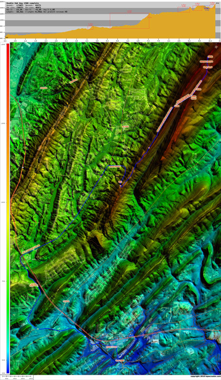
 The Double Oak Way 1500ft climb (medium version)
Huge version (5.9MB)
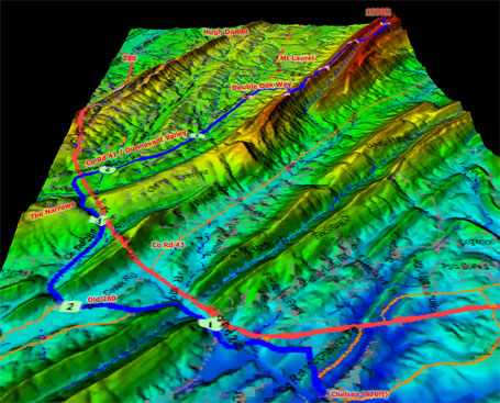 3D map of the complete Double Oak Way 1500ft climb
The Double Oak Way climb has been a favorite of mine since I first rode it a couple years ago after somebody at Tuesday Worlds mentioned that they had rode their motorcycle up it the day before. The very next day, I went for a ride out to Mt Laurel and climbed it for the first time. I had scouted it out ahead of time using topocreator.com and knew that the road would take you up over 1400ft, which is very rare for the Birmingham area. The only other climb I am aware of that tops out at over 1400ft is the Pine Mountain climb north of Trussville.
So anyway, my first time up the Double Oak Way climb was the summer of 2008. Since then, I have climbed it probably 20 times over the course of a couple years. Well, as I was working on the topocreator.com website last night (yes, it is going to go into real beta testing soon!), I stumbled across a topocreator map of the climb and noticed for the FIRST time that there was a small thick contour line representing 1500ft not too far from where the road ends at the radio towers. The towers are at an elevation of just over 1450ft, but less than 3/4 of a mile away was the opportunity to ride up to 1500ft. I immediately scanned the map to find the lowest point in the area to see just how big a climb I could make it. And it turns out there is a spot in nearby Chelsea at 475ft meaning that the total vertical relief was just over 1000ft. Plus with a few downhills thrown in throughout the climb, there is over 1700ft of total elevation gain in the 10.3 mile climb.
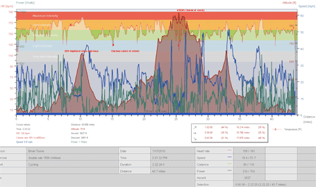
Today, for the first time I did the complete 10.3 mile climb topping out at 1502 ft. Let me take you through the climb as I remember it. First, I didn’t get started until later in the day, so I knew that the only way to make it all the way out to Chelsea and back before it got dark was to bee line a good portion of the route on 280. Once I made it to Chelsea, I promptly turned around and began the climb. You first go through the Chelsea Corners shopping center before crossing under a small railroad bridge where the road turns into onto Old Hwy 280, which follows a creek on a fairly gradual incline right between these towering cliffs on either side of the road and creek. At the top, I just missed the light to cross 280 so after a short wait, it was game on again to finish the climb. There are a couple of steep rollers as you head out on Co Rd 41 towards Mt Laurel. Then, once you make the right turn onto Double Oak way just on the outskirts of Mt Laurel, the real fun begins!
The climb hits you hard right at the beginning with a 0.6 mile stretch that climbs 389ft for an average gradient of 11.8%. There are a couple of short spots where the gradient approaches 25%! There is also a gate about 3/4 of the way up this part of the climb, where you have to dismount and literally climb through the middle of the gate between the thick bars to keep cars and motorcycles out. Remount just in time for the 20-25% “am I going to fall over” 1/10th of a mile stretch which I went up at 7.1mph (avg), 5.9mph (min), 9.2mph (max). The next part of the climb starts out with a short steep downhill followed by the start of the next section of the climb, which is a 1.75 mile stretch with an average gradient of only 2.75%. This is where the best views are, too, and it is so nice and peaceful to ride on a road without any cars at all! The only thing you have to worry a little bit about is deer. I startled three on the ride today narrowly missing one on the way back down!
The road kicks back up to 16% gradient as you make it to 1425ft at the top of this first crest. On the other side, is a super steep downhill (20%) that bottoms out before you immediately start climbing again at nearly a 20% gradient up to the radio towers. This is where I have turned around the past 20 times I have done this climb. But after seeing the topocreator map last night, I knew that I was going to do my best to make it to the 1500ft circle on the map! So I headed off-road onto what is probably a hunting trail (have to be careful about that, I tried to make a lot of non-deer sounding noises, i.e., whoops and hollers which was pretty easy since I was having just about as much fun as I have had all year on the bike!). I followed the trail which was mostly double track covered in leaves and even some grassy areas. I flew through this area which was fairly flat at 1450-1475ft before it dives down again to an intersection with what is probably a motorcycle dirt trail judging by the ruts and rocks. This was really hard to ride because the rocks were big and loose.
At the intersection with another trail, my memory was getting a bit hazy about where to find the final stretch back up to 1500ft, and I almost turned around thinking I had missed it when I looked up and saw another split in the trail heading up to the top. It was super steep, sandy in spots, rutted, and rocky in some spots so I wasn’t sure if I was going to be able to make it up the 1/4 mile trail with max gradient of 18%. But as I got further and further and hadn’t fallen off yet, I thought maybe I could make it to the top. Alas, I got stuck in a rut not 50m from the top and decided it would be faster just to run the rest of the way up. At the top, there was another path off the trail that led to some rocks where I got a few of the pictures below. I had made it to 1500ft. Total time for the climb – 10.3 miles in 41 minutes for an average speed just under 15mph!
It was beautiful, and the sun was getting ready to set so I couldn’t enjoy it long. Took a few pictures and then booked it back through the trails, over Hugh Daniel, back across 280, and all the way home just after sunset. It was an amazing awesome ride. Check out the maps, pictures, and data below. Also, the bottom map shows the climb in relation to several of the other climbs and high points in the area. So who’s going to go with me next time??? I can’t wait to tour guide this climb to some adventurous riders!!! Click on the maps for the “medium” version or click on the link marked “huge” for a huge version where you can read all the residential road names.


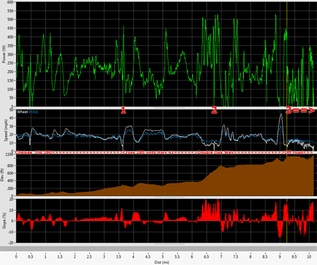
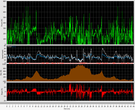
 Complete ride, shows entire 280 corridor (medium version)
Huge version (17.9MB, prints at resolution of 84″ x 84″)
Leave a Reply