This ride started and ended in the land of the delta blues with a lot of delta blues in the middle, too — but no pouring rain. Instead, it was beautiful dry weather with a wind blowing pretty strong behind me as I headed north. Unfortunately, the wind did not die down much during the night so I had to ride straight into it on the way back. This pretty much shut down any hope I had of completing the entire ride (or at least the first 400 miles of it) in under 24 hours. I stopped pushing the pace hard after the first 24 hours so that the last 33 miles ended up taking about 2.5 hours to complete, with the entire 416.8 mile riding taking 26.5 hours at an overall average speed of just under 17mph including stops for food/water/pictures/deep gravel.
Speaking of gravel, the entire route was paved except for two sections of gravel that totaled about three miles. The first section had freshly laid gravel that I fish-tailed my way carefully through quite slowly. The other section was older gravel so it was a bit faster, but I still took my time to make sure I didn’t pinch flat having already had four flat tires in September and October.

All of this was for my Monday/Tuesday fall break at Samford University just two days after the amazing Delta Epic race. I was not able to race the Delta this year because the rest of my family was out of town for the weekend, and we had two sick rabbits that needed lots of care. So with my wife getting back Monday afternoon, I headed out for the 3.5 hour drive to the “Top of Mississippi” watching the full moon setting in front of me on my drive west. I had scouted out a Walmart parking lot in Horn Lake where it looked reasonable for me to leave my car for 24 hours. Not all Walmarts are created equal — you’ve got to make sure it’s a big enough parking lot that nobody will care. I was a little concerned when I got there given that there were a whole bunch of shopping carts scattered all around the far parking spots, which I thought might mean that the parking lot did indeed fill all the way up and there could be a manager watching for cars parked overnight. But given that it was a Monday morning, I wasn’t too worried.
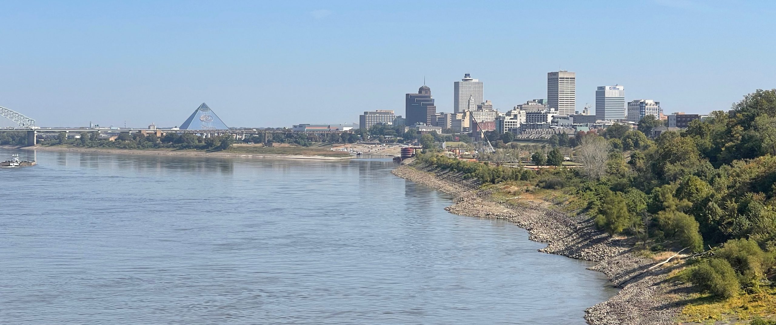
I left heading due north towards Memphis quickly crossing into Tennessee through residential neighborhoods. As soon as I made it past the first traffic light, a bike lane opened up – but it was full of debris. Thankfully, the street wasn’t very busy so I could weave in and out of the bike lane as necessary. As I got closer into Memphis, I could see the Big River Trail bridge ahead and worked my way over onto the bridge. This bridge has an add-on bike / walking trail that is attached to the side of two railroad tracks. I first crossed this bridge in 2019 in Ride4Gabe 4.0 when we were biking from Birmingham all the way to Pike’s Peak in Colorado. I remember being in awe by the bridge, the water, the Memphis skyline along the shore, and the train tracks.


Crossing the bridge less than an hour into my ride meant that I was crossing over into my third state of the ride in under an hour! It would take another 4 hours to cross Arkansas into Missouri and then another 7 hours to make it up into Illinois after an extended detour back across the Mississippi River into Tennessee to chase two hard-to-reach counties in the corner of the state. But from Illinois into Kentucky was only about 20 minutes given the small portion of Illinois that I was crossing sandwiched between the Mississippi and Ohio rivers right there at the confluence of the longest river in North America with its largest tributary (by volume). That was evident in person as the Ohio River was much wider and larger than the Mississippi at the spot where they join, which caught me a little bit by surprise. Also, as it got later into the night, traffic was pretty much non-existent. I was only passed by 14 cars crossing Kentucky on a major US Highway (51) … and most of those were near the bridge over the Ohio River shortly after entering Kentucky around midnight.

Counties and States
I am trying to ride in all the counties in the southeast: Alabama, Mississippi, Florida, Georgia, Louisiana, Tennessee, Arkansas, Kentucky, South Carolina, North Carolina, Virginia, and Maryland. I’ve already completed the first five states listed above, but I’m still working on the next seven. This ride finished off all the northwestern counties of Tennessee, so now I’m only one or two rides away from having ridden in all the counties in Tennessee.
Riding in those northwestern counties of Tennessee was the primary goal of the ride, but as I was planning out the route starting from a park in Memphis, I realized I could not only hit all those counties, but also ride through five states. As I planned a little more, I realized that if I started across the border in Mississippi, I could bring that total up to SIX states in a single ride.
Then as I was finalizing the route through all the northwestern counties of Tennessee, I realized that I could shorten the ride and avoid some major zig-zagging by crossing the Mississippi River from Missouri back into Tennessee to hit the two hardest to reach counties in that part of the state as circled in the map below. This circled out and back portion added almost exactly 40 miles to my route. Another surprise I have circled on the map below (in blue) is that I would ride through two counties named Mississippi: Mississippi County, Arkansas and Mississippi County, Missouri!

Another goal of mine is to cross all the bridges over long rivers. I’m almost done with the Tennessee River and am surprisingly close with the Mississippi River, too, because there are so few bridges over North America’s longest river and because I have relatives who have lived near the river in the upper midwest in a few different places.
In any case, the detour to make it to/from the remote northwestern TN county (Lake County) meant that I was able to cross the I-155 bridge both directions over the Mississippi River. Note that this section of I-155 is combined with US Hwy 412, and there are no “No pedestrians/bicycles” signs on the access ramps or minimum speed limits on the interstate itself, which I used google streetview to assess ahead of time. I’m pretty sure if there are no alternate roads, US law prevents limiting access to portions of the interstate that are also merged with US highways – or at least that is the way it should be.
Unfortunately on my return back across the river on the Tennessee side of the bridge heading back north/west, I saw a “pedestrians, non motorized traffic, motor driven cycles PROHIBITED” sign at the beginning of the bridge, which was pretty ridiculous given how wide the shoulder was. I will pay a fine and/or fight it in court – consider it my act of Civil Disobedience given that one has to ride/walk over 50 miles to the north to reach the Hickman ferry or over 100 miles south to reach the Memphis bridge. We as a society should prioritize non-motorized travel over motorized travel. It might be many years from now, but eventually our society will realize what a mistake we have made in shaping society around motorized travel instead of shaping motorized travel around society as it was for the thousands of years before. That decision has led to so much “busy-ness” with people over-filling their schedules and attempting to use cars as “time machines”. It is pretty ridiculous – most people just don’t see it yet.
I feel like the sign is more of a CYA so that if someone is hit while walking or riding, the state would not have liability. To provide sufficient safety infrastructure, which could be as simple and cheap as a concrete barrier, would require smaller lanes or a smaller shoulder for motorized traffic, which does have negative consequences (i.e., you have to drive slower for the equivalent amount of safety while driving, which people will not do). Or perhaps instead of sacrificing lane space, you could spend millions of dollars to have constructed the bridge a few feet wider from the beginning. That is a LOT of money to spend for a tiny number of people … so I get (but do not agree with) the decision not to add safety measures for non-motorized traffic. Instead of prohibiting non-motorized traffic, however, there should be a middle ground where it isn’t against the law, but you assume all risk as a pedestrian or cyclist, which in practice we do anyway.
In any case, the bridge itself was quite new and had a huge shoulder – unlike some of the other bridges over the Mississippi (e.g., I-20 in Vicksburg), which have narrow lanes and only tiny debris-filled shoulders. Unfortunately, this interstate itself had road construction on the Missouri side of the river, where a repavement had just been finished. They had one lane closed, which I could see as I was biking southbound, so I thought “great, I will just ride in the closed lane”. But almost an hour later when I was returning, I ran into the construction crew who had literally just finished removing all the cones and reopening that second lane. So I had to ride the shoulder which was covered in lots of pavement debris from the repaving. Thankfully, no flat tires during the several miles of debris. I got a break at an old weigh station which was closed and had not been repaved, so that was about a quarter mile of debris-free pavement.


(100 miles away)


With a huge relief having finished the only “questionable” part of the ride, I made it off the interstate back onto a state highway taking me up into Caruthersville, Missouri where I ended up riding right by a football field as a high school football team was walking off the field finishing practice. I waved and somebody yelled something, I hope it was friendly, but I couldn’t hear so I just kept waving and riding. I stopped at the Pilot at the I-55 intersection for my last “this gas station will be open for sure” stop.
The next part of my ride was alongside I-55/US 61 for many miles, but thankfully on a frontage road instead of the shoulder. My radar kept being triggered by the I-55 traffic so I had to look behind me to verify whether the cars were actually behind me or the interstate. I was concerned about my battery wearing down so I had it plugged in to my external battery pack, but given how busy I-55 was I was concerned that I would also completely drain the battery pack by morning since every time a car approaches the light switches to maximum brightness. Thankfully, as I would soon find, out my southbound trip would be practically deserted which meant I could run the light/radar on its lowest setting and get it charged back up to full before morning.
Before making it to my northernmost point in Illinois, I had to ride through the center of the New Madrid seismic zone in New Madrid, Missouri. By this point it was approaching 10pm, so the town itself was pretty deserted as was the main highway heading out of town east towards the Hickman Ferry, County Hwy Ww. I turned off the highway to head north on County P, as the ferry would not still be running this late at night. I was, instead, heading up 40 miles farther north into Illinois to cross both the Mississippi and Ohio Rivers at the confluence on two separate nearby bridges on the south side of the town of Cairo, Illinois.
I started seeing mileage signs for Cairo, IL and Wickliffe, KY and Paducah, KY once I made it through Charleston, MO and turned onto US Hwy 62 east. Slowly, but surely I made it to the Mississippi River crossing into Illinois and was surprised by how small the river was … especially given how wide the Ohio River was even visible at night from the Mississippi River bridge. Upon “landing” on the Illinois side of the river, I turned immediately into a parking area for the Fort Defiance state park with a historical sign to take a picture since there was no “Welcome to Illinois” or “Illinois state line” signs anywhere to be seen. Presumably, the “Welcome to Illinois” sign would be a little farther north past the turn I needed to take to cross the bridge over the Ohio River into Kentucky, which was only a couple hundred meters (if that) past the end of the Mississippi River bridge. Both bridges were quite small one-lane each way bridges with no shoulders given how long the bridges were. At midnight, this wasn’t much of a problem other than there was still a few trucks and cars out.


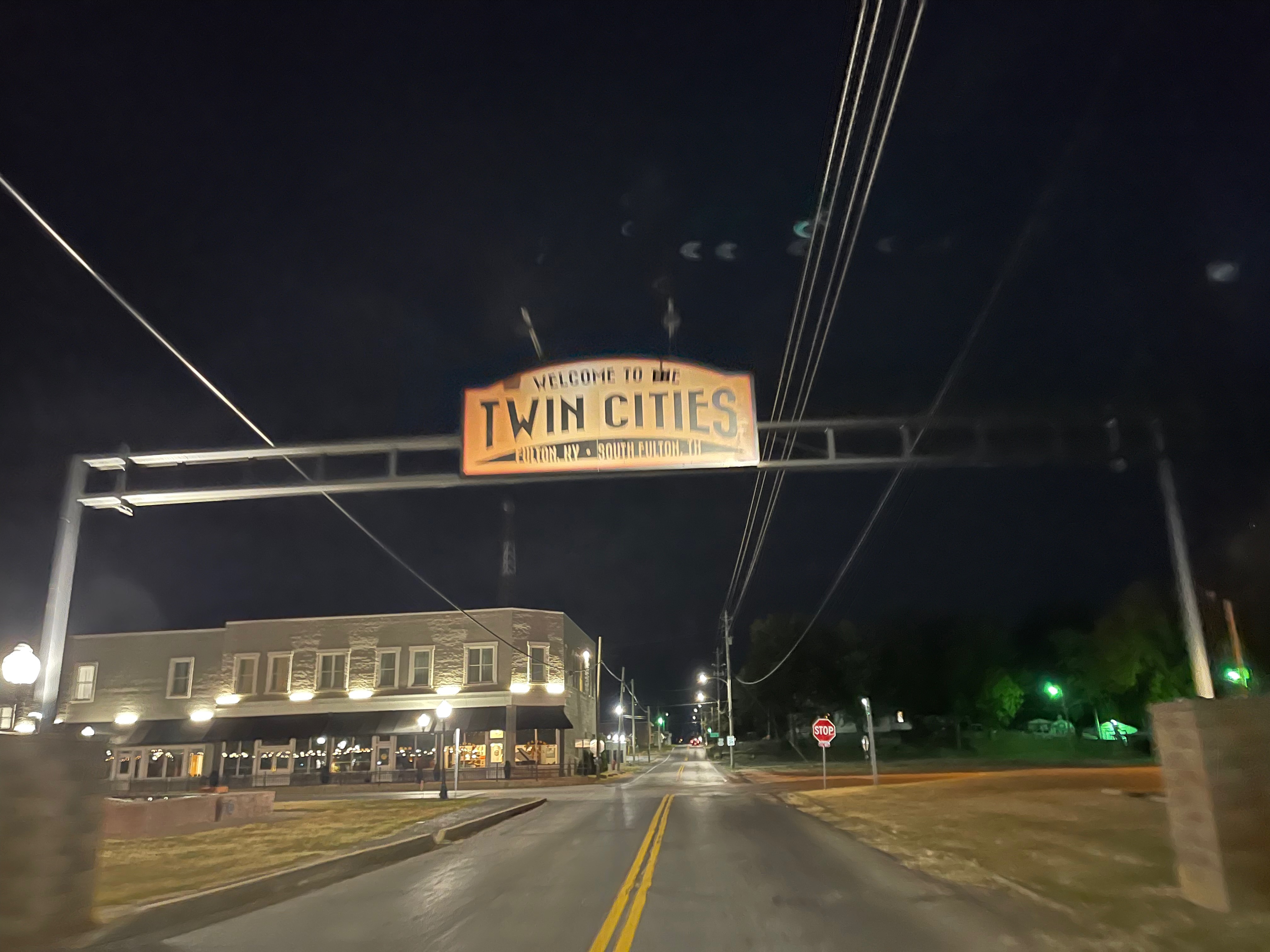
On the Kentucky side of the bridge, I was passed by nine cars and trucks over the six mile stretch of flood-plain heading into Wycliffe, KY. After Wycliffe, I would only be passed by FOUR more cars for the remaining 40 miles of Kentucky, even though I was on US Highway 51 the entire way through the state. Earlier, while I had been riding north on US highway 61 for close to 200 miles from Memphis, I kept thinking that if I just kept going I would end up in the “Twin Cities” of Minneapolis/St Paul. So I was quite surprised when a few hours after turning around and heading south on the Kentucky side of the river on US Highway 51, I made it to the “Twin Cities” after all … albeit the Kentucky/Tennessee version, lol.
By the time I made it back down into Tennessee, it was now approaching the middle of the night and I was getting pretty sleepy. I rode right through downtown Martin, home of UT-Martin, which usually has a pretty big presence at one of the annual computer conferences I have frequented in the past. I had scouted out the location of the university ahead of time and it was a few blocks to the west out of my way, but I had planned on veering over there just to ride through campus. But as I made my way through the streets of Martin, I decided I was too tired and just wanted to keep on going while my momentum and speed were good. Especially since I had been riding into a headwind ever since crossing the Ohio River and turning south. By the time I hit Martin, the wind had started to die down a bit and I wanted to keep on rolling. I did see a giant UT Martin silo at the next town I came through, Sharon, TN so I snapped the pic of that and kept on riding.

After a few more small towns, the sunrise was approaching and traffic started to pick up a bit. I knew I still had a long ways to go since I was in the middle of crossing the entire state from North to South to get to Memphis, but I knew I might hit some Memphis morning rush hour traffic. I was pleasantly surprised by relatively quiet country roads with most of the traffic heading back the other way! I still can’t figure that one out, but I’m guessing it was school traffic for the towns I had just passed through. Another surprise, though, was riding through a controlled burn with lots of smoke in the WMA following the South Fork of the Forked Deer River. I passed a few of the other forks of the river too and kept laughing at the signs because by this point about 21 hours into my ride, I was pretty giddy with the sunrise and excitement for a new day and knowing that I was basically “almost” done with about 75 miles left.
Cotton and the Land of the Delta Blues
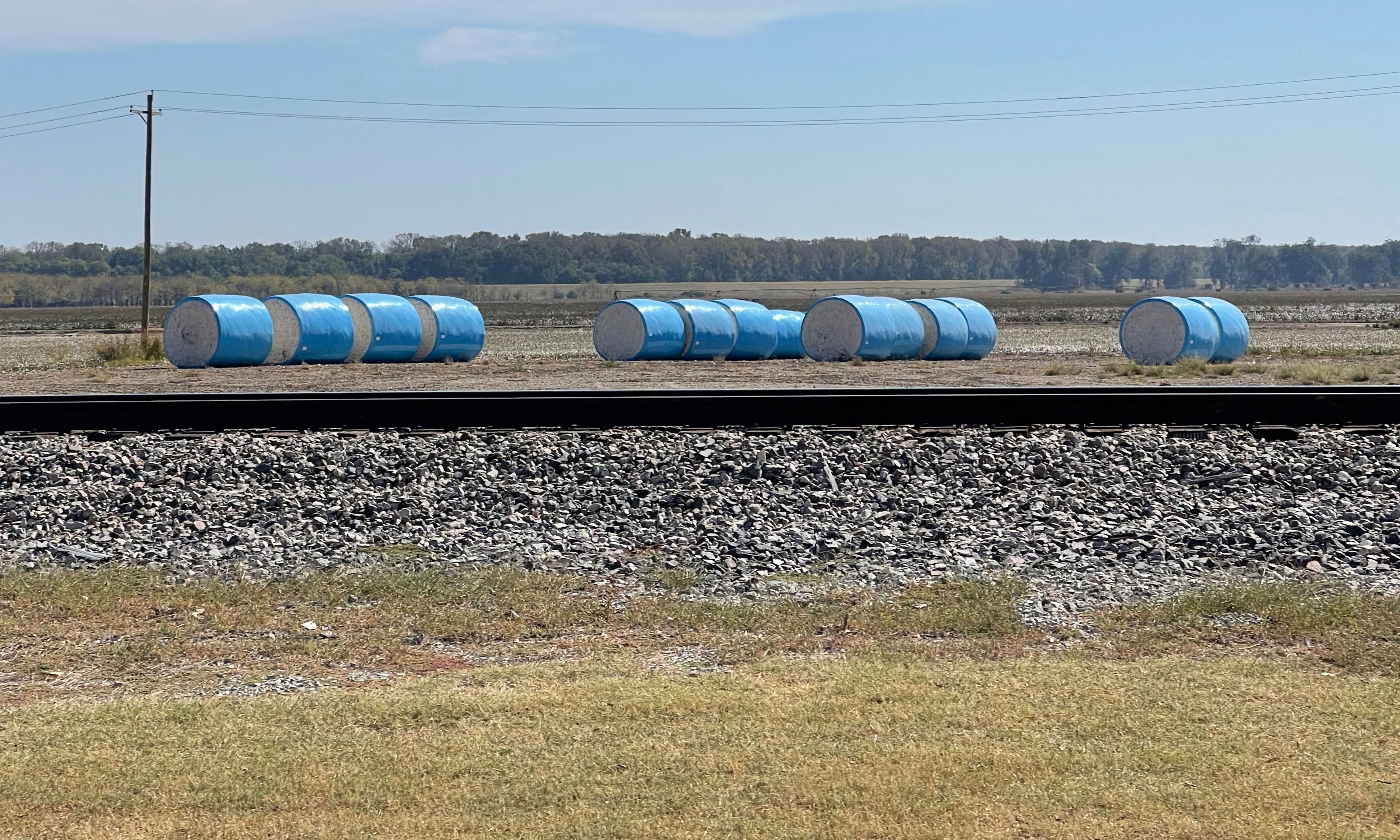
I noticed by this point that I had returned to the land of cotton as I started passing and riding through large fields of cotton and seeing brightly colored wrapped cotton bales, again. Many, many, many miles of my ride north on the west side of the Mississippi River earlier in the ride had been through fields of cotton. On the way up, I kept seeing a lot of crop duster airplanes flying low and eventually I had one that kept following me that I was somewhat racing to beat him to the next crossing. This led to some good pics I’ve included in the pics below.


In addition to all the cotton, I started noticing more signs for famous musicians, which I had also seen earlier in the ride. I’ve collected all those pics into the gallery below.


Concluding thoughts
When I was planning out the route, I noticed that Google bicycling directions routed me right past Graceland, the Elvis Presley mecca. I thought that would be cool to check out at the end of my ride, but you had to pay to even get into the parking lot, so I didn’t want to fool with that. Also, I was kinda annoyed because I’m guessing Google was expecting me to ride the sidewalk (most definitely not a bike path) because there was a mostly un-rideable bike lane that would appear/disappear and an extremely busy highway (lunch traffic, I believe). In any case, it was totally not worth being on that road as there were much quieter roads in the area. Normally, I’m very happy with the Google bicycle directions routing, but this was a bit of a disappointment.
Still, all-in-all, this was an amazing ride with the views of so many cotton fields, the fun of riding fast with a tailwind, plus the challenge of riding through the night into a headwind while sleepy, five big river crossings, and covering 21 counties and six states – it was definitely an adventure. Why would I ride so far? Well, the adventure and exploration is enough reason for me, but this was also training for the Paris Brest Paris 1200km race next summer (August 2023), which will basically involve two back-to-back slightly shorter versions of this ride! I’ve already completed a qualifying 600k here in Alabama that should land me into a slightly earlier “pre-registration” bracket in early 2023. So much can happen between now and then, so it’s hard to plan, but you have to at least try!
All the data and MORE MAPS
Click the image below or navigate to https://www.mybiketraffic.com/rides/view/29828 to see where all the cars passed me on this ride and how fast they were going.
Also, this ride has moved me up to just ONE MORE RIDE that I’m planning on the way up to Virginia for Thanksgiving this year. Here’s the remaining counties along with the five states I’ve already finished riding in.

Leave a Reply