TLDR – quick stats and map

- Day 1: YELLOW – the Alabama Skyway – 273.51mi. (22,838ft)
- Day 2: BLUE – the Cohutta – 177.57mi. (19,836ft)
- Day 3: RED – the Memories – 177.20mi. (19,344ft)
- Day 4: ORANGE – the Counties – 256.04mi. (16,388ft)
- Day 5: PURPLE – the Home Sweet Home – 173.77mi. (14,639ft)
- Total: 1058 miles, 93k feet of climbing
- 49 counties
- 5 states
- 3 state high points – AL-GA-SC
- 3 bears
- 2 tri-state points – TN-NC-GA and NC-SC-GA (Ellicot’s Rock)
- 1 quad-county point
- 1 horse being fed through a house window in someone’s front yard
- 1 woodpecker
- 1 fox
- 1 groundhog or beaver
- several snakes
- lots of deer
- lots and lots of rabbits
Originally I was going to ride a big chunk of the Tour Divide route in Colorado and New Mexico this week while my son was at the Fort Lewis summer mountain biking camp, but we had to cancel when my son broke his finger falling off a bridge at the start of a mountain bike race. Coronavirus was already threatening the camp, so I had been working on a backup route through Alabama, Georgia, Tennessee, North Carolina, and South Carolina to try to replicate multiple 200 mile days in a row on gravel roads as well as a ton of climbing on a heavily loaded bike. I was also going to try my hand at trail-side camping in a hammock, but riding in multiple downpours each day usually at sunset or later made me switch to backup plan of cheap motels. While this made the trip more expensive than I would have liked, it definitely made dealing with the rain and heat much easier. I did laundry twice, and it was nice to start out the day early leaving a cold hotel room instead of starting out the day already hot and dehydrated from sleeping outside in the hot, humid south. That’s the quick summary, here’s all the details I remember!
Day 1: Hoover, AL to Dalton, GA via the complete Alabama Skyway – 273.51mi. (22,838ft)

Not wanting to split my mileage between two different weeks, I waited until midnight Monday morning to leave home so that I could try to ride as much as possible at night. My original plan was to hammock on top of Taylor’s Ridge on the Pinhotti. But thunderstorms had other ideas. I decided to stay down lower in the valley on actual roads and try to make it all the way to Dalton to spend the night in a hotel.
Long before that I ran into my first problem – missing chain lube. I had stuffed a small travel bottle of chain lube in a ziplock bag with a few other ziplock bags and wedged in very tightly on the outside straps of my rear saddle bag. A few miles after descending Flagg Mountain I noticed my chain was getting noisy from the dirt roads. So I decided to make a quick stop to apply some chain lube when I noticed it was no longer there! This was a big problem with all the rain, dirt, and mud ahead on my route. But at this point I wasn’t too panicked as I still had a couple ziplock bags in my top tube bag for my Garmin and my phone and I figured I’d be able to find some chain lube along the route at some point (it ended up taking FOUR days to find some, although I bought a big pack of ziplock bags at the Cheaha store and they came in VERY handy the rest of the ride).
Before the chain lube situation, I had had an amazing ride straight down Highway 31 before veering left in Calera on a new-to-me dirt road paralleling I-65 for quite a ways. It was a good, fast dirt road that was far smoother than the chip/seal preceding it. I crossed right by the Yellowleaf grist mill before hitting Co Rd 55, which takes you all the way to the base of Flagg Mountain. Thinking that I wouldn’t have electrical power for two full rides, I was very conservative with my lights. The very bright two/thirds full moon and partly cloudy skies let me ride nearly all of Co Rd 55 with no lights at all. The moon was bright enough to cast shadows while I was riding and there was only one or two cars which you could hear for a long ways on the chip/seal.
By the time I made it back down Flagg, it was starting to get light. I was still pretty heavily loaded with food and water so I skipped the first gas station on the Alabama Skyway route (which starts/ends at Flagg Mountain). The dirt/gravel roads that cut over to Wiregrass Rd from Weogufka were all new to me. Wiregrass itself was great until you started climbing past the new spillway bridge area. I had to do a couple hike-a-bikes through the woods to avoid very sticky, nasty looking mud. Thankfully these were short and quick so I didn’t lose too much time. The skyway itself (skyway-1, -2, and -3) were all in bad shape with huge mud puddles in spots and lots of rocks and ruts. The storms from the past week had been hard on the skyway. Eventually, though, I made it to Adams Gap and knew that I had a long stretch of pavement with lots of climbing ahead of me.
Starting to get a bit later in the morning, but it was nice to have one or two more cooler spots on the descent down from Adams before it really started to get hot on the way up Cheaha. It was hot by the top so I refilled with lots of gatorade and water and food. I knew this would be the last stop before Piedmont at the earliest, but it ended up being the last stop before Cave Springs, which was my last stop of the day … meaning I made it the 273.51 miles to Dalton with just two store stops. Part of the reason why I was able to make it that far was b/c of the rain causing me to switch up my route and stay down on the much faster valley roads instead of the steep dirt climb along Taylor Ridge. This meant I missed my first fire tower I was hoping to climb, but definitely not climbing that in a thunderstorm. It rained and stormed off and on all the way into Dalton where I pulled into a Super 8 just before 11pm.
Day 2: Adventuring with the bears in Cohutta – 177.57mi. (19,836ft)

Seeing as how slow the first day went and knowing that I would be especially slow through all the dirt climbs on day 2, I started out by bee-lining it over to the paved version of the Fort Mountain climb leaving the hotel at 4am. I had routed myself up the reverse TNGA route climbing Fort Mountain in the dirt, but it was longer and definitely slower. Since I was somewhat on a schedule to make it home Friday evening, I knew that I was going to need to look for ways to shorten the very ambitious course that I had created. Doing the paved climb instead would knocks 10-15 miles off my route and probably 1.5-2 hours. So that’s what I did! And it was great … I got to do the same road climb I used to do in the Heart of the South 500 mile road race. And I got to see an amazing sunrise sky. And I also made it to big climb up to the Grassy Mountain fire tower (which essentially starts at Mulberry Gap) while it was still early morning and beautiful temps. I recognized some of the reverse TNGA on the climb, and it made me super glad to be nice and clean and relaxed and having fun through there instead of tired and dirty and trying to blow through as fast as possible during TNGA.
I was hoping to find/buy/borrow chain lube at Mulberry Gap, but unfortunately I was a bit too early and the only people who were up were guests who didn’t have any with them. My bike wasn’t making as much noise anyway so I continued on and started up the very long Cat 1 climb to the Grassy Mountain fire tower. The lower slopes of the climb had lots of bed and breakfast type houses and mountain laurel blooming everywhere. Along the way in the quiet of the early morning, I noticed how loud all the birds were. There were so many different kinds of birds, it was amazing. The fire tower itself is a different kind of fire tower than I am used to, it’s not the standard cab-based fire tower exactly 100 feet tall. Instead it was a platform tower quite a bit shorter … maybe only 50 feet? In any case, the platform itself was locked so I had to take pics from right underneath instead of up on the platform … although I definitely saw and considered a way to get up there … just seemed a bit dangerous and not worth it.
On the way back down is where I ran into the largest bear of the day. I was coming around a corner after climbing up past Lake Conasagua and started on the descent when I startled a bear on the trail. It stood up briefly to assess but then thankfully almost immediately got back down to head off the trail into the woods. Those bears are LOUD when they go trouncing through the woods like that. The second one I saw was about thirty minutes later while climbing. Off to my right and just slightly below the double track road I was climbing was another bear rooting around looking for food (I guess). I imagine it knew I was there, but it never looked up at me. The last bear was maybe 1-2 hours later, and I was climbing again but I only caught a glimpse of this one as it scampered off the trail and then heard it loudly crashing down the hill beside the trail.
Having raced on the Cohutta 100 a couple times and TNGA a couple times, it gets confusing but I know I was on some of the dirt roads used in both races. One of them was under construction as they had dug up several pipes where the creek flowed under the road and left them open. So I had to scale down into the creek and then climb back up the other side. It was good practice hike-a-bike some awkward terrain with heavy load. I ended up on the long “single track road” all the way over to the Thunder Rock campground on the Ocoee River. Even though it was getting hot, I opted to keep going to avoid the crowd at a potentially closed store (it’s around under the main whitewater center). I made it to the Mccaysville/Copperhill state border town and worked my way over to the tri-state point. I had read about this point and was going to ask the private land owner in either NC or GA if I could see the spot, but they weren’t out and I wasn’t going to go knock on the door as I feel that is too invasive. I rode right on by it, though, and made it onto GA-60 which I knew would take me all the way into Dahlonega. I had already been through one downpour and narrowly missed another when I got drenched by a third pretty much all the way until the top of Woody Gap. Thankfully it had stopped by Woody and I was able to do that descent all the way down into Dahlonega on dry roads. After Dahlonega, I started to chop off more distance by skipping Yonah Mountain and another steep tower climb I had on the route. I also knew that I was hitting a new county over there, but thought I was going to go through it anyway. As it turns out, it was on one of the mountain climbs I skipped. Ugh.
All of the route changes meant I made it to Helen a little before 10pm instead of well after midnight. This was good because it meant I could get an early start even after doing laundry. I went into a gas station and was followed in by a police officer who talked to the store clerk and ended up calling in a medical call as the worker was dizzy. I asked if I should go to another store, and the worker said he could handle checking me out. So I got my stuff and as I was leaving the ambulance came in to check him out more closely.
Day 3: Helen, GA to Clemson, SC via memory lane – 177.20mi. (19,344ft)

I was able to leave by 4am again, and even though the moon was only a half moon, it was still bright enough to do the climbs up Unicoi Gap and Jack’s Gap with no lights. It was sunrise by about halfway up Jack’s and I cruised my way slowly up the rest of the way to the very top of Brasstown. With how busy it is at the summit on normal days, they can’t let bikes up there. But just after sunrise with no one else around, it was perfectly fine for me to ride on up to the top and look around the observation deck. The sunrise sky view was amazing albeit a bit cloud covered and misty.
When I was an undergraduate student at Clemson University about 25 years ago, I would end the racing season with a 200 mile ride from Clemson that climbed up Brasstown Bald at the halfway point. Then I would drop down off the climb and follow pretty much the exact route I followed on this ride. Traffic seemed much busier than I remember. Also, I had planned a dirt climb up through Sky Valley to Scaly Mountain and Highlands, but it turns out it was all private land. So I had to take the main highway, and it was very busy.
Highlands, NC itself was very busy with everyone trying to escape the heat by vacationing high in the mountains. NC has a mandatory mask law which was prominently displayed at the one gas station I entered. Still on the lookout for chain lube, I stopped by a hiking/outdoors store with no luck. Then I continued on to a road with some fun history for me.
I had a giant raised relief map stretching from Anderson, SC to Knoxville, TN that included the Highlands area. It didn’t have a lot of roads on the map because of the scale so I assumed that all the roads on it would be paved. Well, as it turns out, this one road coming off the mountains in Highlands stretching across to NC/SC highway 107 started out paved but then turned to dirt through the national forest. I had never ridden my road bike on dirt roads before in college. I was with a couple friends and we dropped off the mountain on a super steep paved switchback road that had a lot of paved washboard that felt like was going to break the bike into pieces. At the bottom was nicer pavement in this beautiful valley at the base of Whiteside Mountain. I was riding along ahead of the other two guys and crested a hill and noticed a small pack of dogs in the middle of the road on the downhill. The proper behavior in this situation (normally) is to stand up and sprint straight towards the pack of dogs and this will (normally) scare the crap out of them and they will scatter. This almost worked for me back in 1997. All but ONE dog took off every which way. But that one dog entered a head-on game of chicken charging straight at me. The dog won as I slammed on my brakes and veered off the road to the right. The dog came straight in, bit my calf, and then took off like a bandit.
As I looked up from the bite and the other guys caught up to me, we saw two signs next to each other … “pavement ends” and another informational sign NC/SC 107 – 10 miles ahead. So we started along across the Chattooga River but they were struggling so I decided it would be best if I went ahead and got the car and came back for them. I was doing OK, but I had also run out of food and water. There was an apple stand once I finally made it to Hwy 107. I didn’t have any money, but the guy had pity on me and gave me an apple, which I devoured immediately as I sped off to get the car and come back.
Well that was 23 years ago. Unless it was a super-old dog, it is long dead. Still, I looked for the dog and was concerned there might be new dogs at the house on this ride. No dogs at all. Plus the washboard descent had been repaved and was smooth as butter. The only problem I had was catching a very slow moving car by the bottom that I hadn’t even seen pass me before the descent. Thankfully it was near the very bottom so I didn’t have to wait long for them to finally let go of the brakes and venture off into the valley.
I did eventually make it to Highway 107 again but this time I was taking a new route from there that would cross over to Whitewater Falls (highway 130) and then climb back up again to Hwy 64 to make my way over to Rosman and on up to the highest point in South Carolina – Sassafras Mountain. Everything went great and even though there were storms nearby, I only had to endure one short downpour. Whitewater Falls was roaring, but I have seen it even more full after flooding rains instead of these summer thunderstorms. There is a new lower section of the falls that is now open to the public. This looks spectacular from satellite imagery but it is 1000 feet down the mountain in the pump storage facility and was previously closed to the public. It has been opened fairly recently, but there was no way I was dropping down 1000 feet and then turning around and climbing back up that same 1000 feet before heading to Sassafras. This easily saved me 30-40 minutes of riding. Plus I had scrapped plans to climb another high peak on the way to Whitewater off 107. This saved even more time (possibly an hour or more), but it did chop off another 1500 feet of climbing from my ride.
It was a smart decision though because it meant I could make it to the top of Sassafras before the early evening thunderstorms started to roll in behind me. I had Sassafras Mountain to myself entirely! It’s not a very busy place normally, but everything else (including Whitewater Falls) had been so busy that I thought for sure there’d be someone else at the top of South Carolina … but nope, all alone to discover a new lookout platform that had been built since the last time I was there with Kristine and the kids to see the total solar eclipse in 2018. The views of Lake Jocassee, Lake Keowee, and Lake Hartwell off in the distance were phenomenal. There was lots of lightning in the area from a storm that was building just behind me in Rosman. So after snapping a few pics, I bombed the descent (58 mph on the chimney gap flume) and made it onto Hwy 178 and down Beasley Gap and all the way out to Six Mile Mountain (there’s another great story there about a fire tower, a sunset, and a concussion I will save for another day).
There is a spot just past six mile mountain where you can look back and see the three highest peaks in South Carolina all lined up together. I realized as I took the picture and texted it to my wife that I have now taken that same picture in not one, not two, not three, but FOUR decades (90s, 00s, 10s, and 2020). After I write this all up, I’m hoping to do a side-by-side of one pic from each decade.
Long before I made it to this spot, I had canceled the route I had planned and decided it would be way more fun to make it back to Clemson on one of many routes that I’ve taken that would take me past this spot rather than the nostalgic “original route” that I had charted out before leaving. Beautiful, beautiful pink, purple and orange sunset sky that Clemson is famous for (and is the school colors). It was so amazing. I did spend the night in a live-in motel (you’ve got to pay by noon the next day) but I was only there for a few hours and was looking for the cheapest place possible. Also, since I had done laundry the night before I didn’t need to do laundry again so I could just lock the door and go to sleep. A few short hours later I was up and on my way for Day 4.
Day 4: Clemson, SC to Douglasville, GA via “Gerrywandering” – 256.04mi. (16,388ft)

Georgia is well known as a highly gerrymandered state with political boundaries drawn meticulously to control the voting public. Thankfully there are changes being put in place to make voting more representative of people of all races, ethnicities, and economic status, but those changes don’t usually affect county borders which are much more permanent than voting districts. The counties in Georgia are some of the most intricate county borders you will find anywhere in the country (thanks I’m sure to gerrymandering).
One of my goals is to ride in every county in Alabama, Mississippi, Georgia, Florida, and Tennessee … then working out from there probably South Carolina and possibly North Carolina. I’ve already ridden in all the counties in Alabama (in one year even!). I’m closing in on Mississippi – can probably knock out the rest in three or four rides. But Georgia I still have a ways to go because there are a lot of counties. When I was figuring out a route to get back home after making it to Clemson, I decided to route myself through a lot of the counties on the east and south side of Atlanta.
I started out by riding from Clemson to Athens past the big Lake Hartwell dam at the official start of the Savannah River. Leaving Clemson, I took the quiet, rural Fants Grove route that takes you through the experimental forest and farms which means there are very few houses until you get closer to the interstate. It’s also quite hilly and as I was flying down the last big hill to Eighteen Mile Creek, I came across a car on the side of the road with its lights on. My first instinct was hunters getting ready for the day (although it’s wrong time of year) but as I glanced over as I passed something definitely didn’t look right. I slammed on the brakes and turned around and started climbing back up the hill to the car where it became clear that the car was wrecked. I hollered out “are you OK?” with no response. I called 911 immediately at that point and got off the bike and started looking around the car. The 911 operator told me to check under the car and in the grass around the car to see if there was somebody unconscious there, but I couldn’t find anybody. The headlights were on, and the radio was playing. The trunk was open at a weird angle with mud all over it, and the right rear wheel was still barely connected but at a nearly 90 degree angle to the side. And the top of the car looked crushed down. So I think the car had rolled and ended up there. The 911 operator told me that medics and law enforcement were on the way, so I told her I was going to ride on ahead in case the man/woman was wandering the road with a concussion looking for a house.
I made it to Athens at about 6:30AM to mostly deserted streets and got to ride backwards on the Athens Twilight course before heading out into the rural stretch of Georgia southwest of Athens. It got really hot as the sun came up. I ended up running out of water and was thinking about filtering some from a creek, but was a little hesitant because of the extensive cow pastures I had just passed. It didn’t matter though because I ran across a man in his driveway and asked if I could get some water, and he brought me out two ice cold bottles as I headed down to the town of Monticello off my route as it was the nearest gas station and yet still almost 10 miles away.
That gas station was awesome, albeit quite busy. I finally found multi-purpose lubricant with a picture of a bicycle on it that I could use as chain lube. It was perfect! It helped quiet my loud chain and the creaking in my bottom bracket from probably the smallest piece of dirt that had gotten in there. I just leaned the bike sideways and let some chain lube flow in. It had taken four days and over 800 miles to finally find some chain lube. Recharged and rejuvenated, I took off from there on some busy, but good shoulder roads heading straight into Atlanta. Traffic was nice, I think they had pity on me given how incredibly hot it was. I had to stop one more time about three hours later as I was out of water again. From that stop until I hit the rockdale trail system, there was no shoulder and so it was a bit tricky for cars to get around but it was still doable. I missed the turn onto the rockdale trail thinking it was a simple left, but you had to go right and then climb up to an overpass to cross over the road so I had to turn around to find the trail and make the turn.
Unfortunately I couldn’t ride the trail system for very long because it wasn’t heading the direction I needed to go, but I was soon in for my first surprise of the day … Jason Spruill, a college racing buddy, had ridden out on his motorcycle to find me and say hi! He had been thinking about riding his bike out to the Rockdale trails and riding along with me, but the timing hadn’t worked out. It was awesome to pull over and chat for a couple minutes. By this point I was getting closer to the airport and the storm clouds were building and you could already hear thunder in the distance. I was on the main flight path into the airport, but the planes were still pretty high in the sky so I knew I had a ways to go – maybe 10-15 miles. I loved the route by the Atlanta airport. Traffic got quieter as I got closer to the airport. By this time it was past 7pm so rush hour had died down. It was awesome to see the big giant 747 planes (one from Qatar flew right over my head) as well as the domestic planes. It started to pour down rain at the airport and that heavy rain and lightning lasted all the way up Mount Everest (my nickname for the eternal climb from the Chattahoochee up to Douglasville).
Also during this time after the airport, I ran into my only major route problem of the trip. My route had taken me straight through a heavily fortified (meaning I didn’t want to try to climb the gate on both sides) private driveway in the middle of a busy neighborhood. It was quite hilly and pouring down rain and this was at the bottom of a steep hill. So to turn around and work my way around back to my original route was going to involve climbing back up the steep hill I had just come down as well as quite a bit of extra mileage. So at that point I just did biking directions using Google Maps from my location to the hotel. And it took me on a completely different route that had a bike lane for quite a while but still had some sections where the lane just disappeared. All of this was in heavy downpour with lightning. I was completely soaked by the time I made it to the hotel. I did laundry and fell asleep with my alarm set for 3:30AM. I didn’t wake up until 7:30AM! This meant I would be riding much more in the heat of the day and finishing a bit later than anticipated, but it also meant I got to ride and see friends on Day 5!
Day 5: Douglasville, GA to Hoover, AL via friends and Cheaha – 173.77mi. (14,639ft)

After great night’s sleep, I was ready to go. It was already warm by the time I left at 8:30. My route started out on Hwy 78 which I knew I could take all the way back to Birmingham, but I still had more adventures planned for the day that would take me farther south, up and over Cheaha from the east. Hwy 78 was amazing with a small shoulder and no rumble strip. It was also heavily treed with lots of shade. I turned off Hwy 78 near Villa Rica to make my way over to Carrolton. This is where Robb Pressley drove up beside me with his bike in the back of the truck saying he wanted to ride with me. I told him that’d be great but warned him I was going kinda slow. It was awesome to ride along with Robb in his hometown, especially the cool bike path they have now.
We rode together through town and out GA-166 where we met Ben Clarke and his family. Ben had called me earlier and told me that my route would take me right past their house and that he wanted to know if I needed anything. I told him that would be awesome to stop and say hi and would save me from a store stop later. It was so awesome to see Ben and meet his family. They had ice and water and gatorade, and it was so great to take a break in the shade (it was getting hot) and relive some of the adventures of the ride before heading on.
Taking off with ice cold water bottles, we headed over towards the state line where Robb turned off to head back home. The state line was unmarked except for the Cherokee County sign, and big change of pavement. Hilarious to go from smooth tarmac to rough chip/seal right at the border. My Salsa, though, loves the chip seal just as much as the smooth tarmac. Very rural I could use both sides of the road to find the shade. All of the roads I was on were new through here including the turn onto what I think is now Alabama’s newest Cat 3 climb on Strava – Turkey Heaven Mountain. This was a great rolling climb on a mix of hard packed dirt and gravel. It was all road bikeable so even faster on my Salsa. The view at the top was awesome with Cheaha in the distance to the west.
Shortly after Turkey Heaven, I climbed up a different mountain in search of a fire tower (which I never did find). I had to hike-a-bike several times both because of the steepness of the “trail” and extreme overgrowth you couldn’t just plow through. Eventually I made it to two different peaks on the mountain and neither had a fire tower so I’m guessing they were torn down and I couldn’t see the base b/c of overgrowth. At least I was rewarded once I finally got off the mountain with a very cool one lane bridge over the Tallapoosa River significantly upstream from Lake Wedowee and Lake Martin which are both dammed lakes on the Tallapoosa River (with Lake Martin being one of the largest man-made lakes in the United States).
After Turkey Heaven and the other mountain, I was back in familiar territory, but instead of hopping onto 78 and heading to the end of AL-281 to climb up Cheaha the normal way, I wanted to explore the “Old Cheaha” road which goes by the Horseblock firetower. It weaves across the main Cheaha road in several places, and this section from just past the Highway 431 intersection all the way up Horseblock was mostly rideable. Somebody hikes and/or bikes on it a lot as there was an easy trail to follow on the old road bed. This road bed had extensive work with several earthen bridges and one mountain cut. It’s crazy to see something like this so abandoned that large trees have grown up in the middle of the “road”. But like I said earlier, somebody hikes it a bunch and I was able to ride over or around most of the treefall with maybe four or five total dismounts over the two mile stretch of the climb up to the firetower to negotiate treefall … which is quite a bit better than 20-30 dismounts on a lesser maintained truly abandoned road through the forest.
The fire tower is still the sketchiest I’ve ever climbed. It was quite windy so I didn’t stay long at the top as I could feel the tower moving in the wind. I’d reckon this fire tower only has a few more years before it gets taken down. You’d better climb it now before it’s gone!
After the Horseblock firetower, I hopped on AL-281, the main Cheaha road, and decided to skip the other section of Old Cheaha I had mapped out. I decided to save it for another day, especially with it potentially being a new Cat 2 climb for Alabama starting down in the creek the old road followed. After the top, I was on a mission to make it home as fast as possible. I took pretty much a carbon copy of the route home we used on the Father’s Day ride a few weeks ago. Near Cheaha Lake on the descent, I ran into Jeff Fuller who was climbing up the mountain. He turned around and rode with me all the way out into the valley. It was great to get caught up and have someone to pass the miles with.
The last surprise of the day was Nick Butler running down from the Shocco Springs pool to say hi and offer me pizza and water. I had just stopped at the gas station down the road so I passed on it, but it was great to say hi for a minute before continuing on up the wall leaving Shocco. Nothing much to report from Shocco all the way back home other than a lot of medical personnel, fire trucks, and police blocking the road near the Logan Martin dam. I couldn’t figure out where the accident was and I think they were wrapping up as I came up on everything.
Sunset was shortly after the dam with the last bit of daylight fading by the top of Vandiver. Plenty dark and I’d like to say “quiet” by the time I made it back into Hoover at 10pm … but it was quite busy with everyone out on a Friday night I guess. Or maybe I had just gotten spoiled by all the deserted roads and areas on this ride. Who knows? In any case, it was nice to be back home.
See many more pictures from the ride and the exact location where I took the pictures on this pickuta album which I used for tracking during my ride:
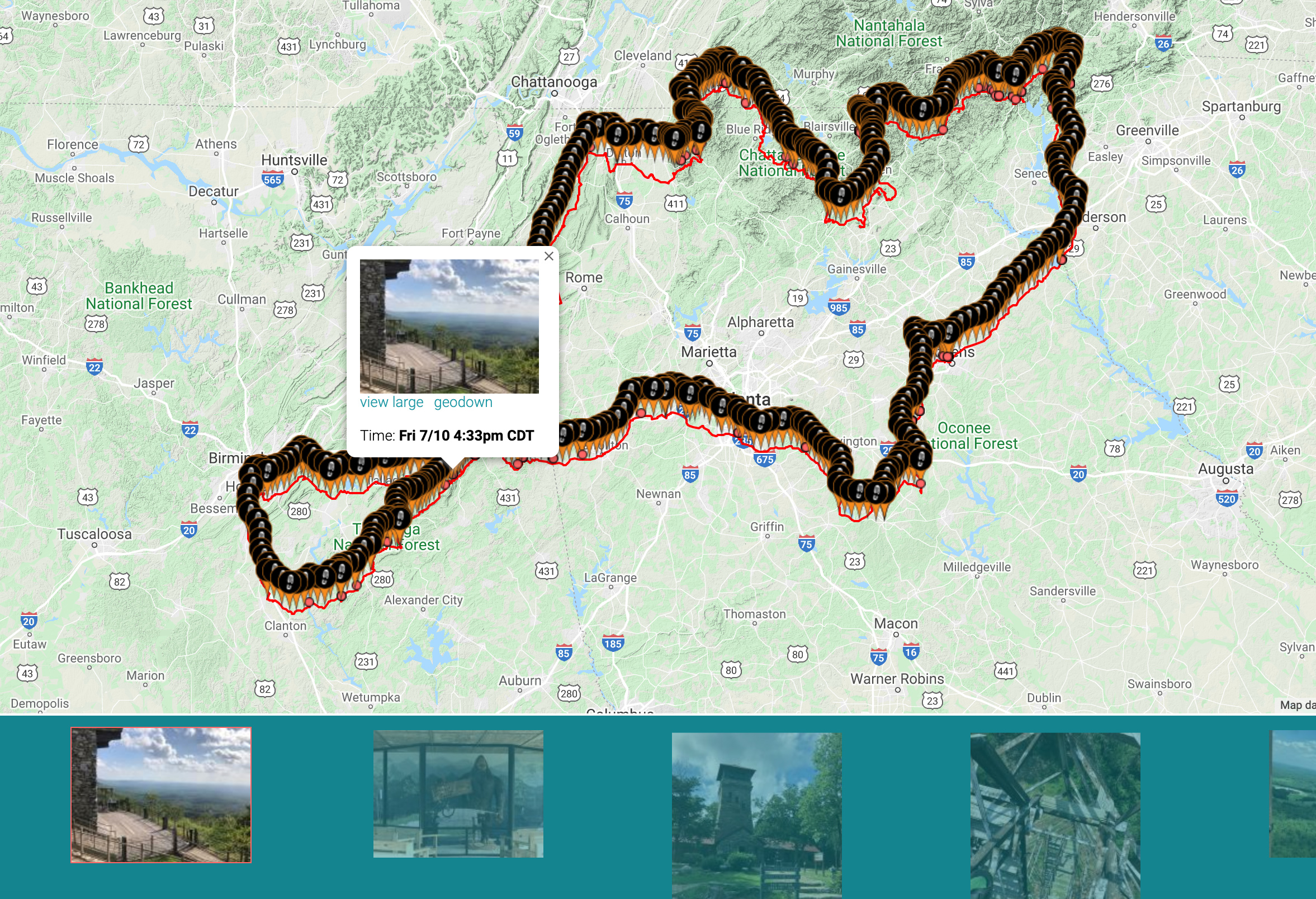 https://pickuta.com/album/177
Leave a Reply