Life has been busy and is about to get busier, but I’ve had some pretty crazy adventures I wanted to blog about. These are ordered below based on when they happened, so you can jump to any specific one with these links:
American Flyers | Just a little commute | Grant ups and downs
March 8-9th – American Flyers – Rouge Roubaix
My all-time favorite cycling movie out of the two that I’ve seen is American Flyers. In the opening scene, the lead actor is racing a barge along the Mississippi River. Then he rides into his building and onto the elevator. I do the latter every day on my commute to work, but I’ve never gotten to race a barge on the Mississippi until my Rouge Roubaix pre-ride this year. The race itself was epic as always – read my race report, but man sometimes I think the pre-rides are more adventurous than the races themselves … see Hell of the South exception, though.
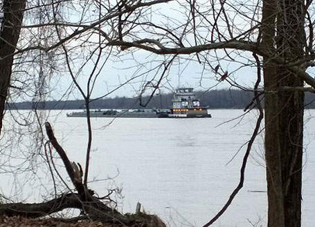 Racing a barge on the Mississippi River – I just “American Flyered” my ride.
One of the ironic things about the Rouge Roubaix race is how close the course is to the Mississippi River, but you can never see the river from any spot on the course unless it is in severe flood stage (see pic below)
 Google street-view of the turn onto 2nd gravel. The Mississippi River was at flood stage when the streetview car drove by. During the race, you cannot normally see the river. For my pre-ride I parked at the store annotated in the picture.
This was my fifth year racing Rouge Roubaix, but I had never gone out of my way to see the river because my time spent there is usually so short. I wanted to include a trip out to the river in my pre-ride this year. I ended up picking a route onto Cat Island that veered off of the race course shortly after the third gravel section (Tunica Hills). My route plan was about 50 miles, which I thought would give me plenty of time to just cruise through the second and third gravel section. After a late start on the 7 hour drive from Birmingham plus a bit of a challenge figuring out where to park and not upset the locals (turns out I could have parked pretty much anywhere), I only had less than 3 hours of daylight left. Not exactly a lot of time to ride the 2nd and 3rd gravel sections plus the 2nd gravel section again on the return route.
I was enjoying a nice easy pre-ride, but as my brain ticked away at timing calculations I realized that there was no way I was going to finish before sunset. I picked up the pace and realized that I was probably going to be making it to the turn-around point of my ride sometime near sunset. Stubbornly, I decided that seeing the river this year was worth riding in the dark with no light. The next challenge was finding a way to the river. I knew that the road I picked out onto Cat Island swung close to the river, but not until pretty far into the island. The road kept getting muddier from rain and floods (pic below was from the early part of the road where it was still easily rideable … imagine entire short sections of road covered in thick mud), so I decided when I caught a glimpse of the river behind a gate with a short dirt road leading right up to the edge that I had found my entry spot.
 Cat Island road – good practice for finding a good line for the rouge roubaix race
 Dirt double track to the river – barge visible in the river
Right after carefully climbing the fence and setting my bike over on the other side, a barge started to pass by on the river. That is when I knew I had to get a pic of the barge. Unsure whether I was going to stumble into a herd of bulls or cows, I took off like a rabbit down the double track to get to the river’s edge and get a pic. The pic at the top is what I was able to get. So in some sense the barge won because it made it past my access spot to the river, but in another sense I won because it was still close enough for me to get a pic!
As you can see from the lighting in the picture, it was near sunset by the time I had finally seen the river. I was taking a slightly different route back to skip the Tunica Hills dirt section, but I still had over 25 miles left to get back to my car parked at Fort Adams. Plus, the very last part of the ride would be the reverse direction of the 2nd gravel section (i.e., backwards down Blockhouse Hill).
Sunset happened before I even made it off Cat Island. By the time I made it out to LA-66, the main road to Angola Prison, it was dark and dangerous (from traffic). I spent most of the 5 mile stretch of road looking backwards ascertaining whether an approaching car was slowing down and/or moving over to pass me. Only twice did it look questionable and both of those happened to be near sections of the road where there was a shoulder so I moved over into the shoulder. When I finally made the turn off LA-66 onto Pinckneyville Rd, I was super relieved even though it was now way past sunset and very difficult to see. Pinckneyville Rd is an interesting chip/seal road that has some really nice sections interspersed with short rough “repaved” or “washed out” sections.
Ironically, the darker it got, the faster I went as I desperately tried to cover as much ground as possible while still able to see the rough sections with just enough time to grab the brakes and roll over them at a non-pinch flat inducing pace. When I made the turn onto the Blockhouse section, I had to rely entirely on the GPS and the fact that I could see a house up on the left to know that I had reached the turn! It was so dark that I could barely see the turn and could not even see the cattle guard. I was wondering if I had made a wrong turn when all of a sudden I bounced across the cattle guard … “yep, I’m good, this is the way”.
The Blockhouse gravel was in great condition, and I knew this from riding it on the way out at the start of my ride. Also, it was a brighter, lighter color because of the sand mixed in with the gravel. This meant that this section was a bit easier than Picneyville Rd to ride in the dark. I could see two things – black and slightly less black which I knew was the gravel road split into a double track. I tried to stay to the left side of the road hoping that I was judging the right spot to end up in the lefthand track. I stopped at one point to try to take a picture of the conditions. These are three pics that I got:


 Top – Blockhouse in the dark (with flash). Middle – My iBike and Garmin on Blockhouse (with flash). Bottom – the road ahead without flash, not even enough light to make ANYTHING out. Although this is partially because my Nokia Lumia 1020 with great low light photography doesn't always auto-detect its settings correctly. If I had manually set the exposure to a couple seconds, you would have been able to see the blurry outline of the road.
By the bottom of the Blockhouse Hill, the road turns from gravel to a partial pavement – which was in really bad shape. Fortunately, this was in a small community that had street lights spaced just far enough apart that I could safely make out all the potholes and slowly ride through. They were having a big party at one of the houses, and some of the kids shouted “hey biker dude” or something like that as I biked by. Epic. Adventure. Life.
March 24th – Short commute to North Georgia
 Map showing my commute from Hoover, AL to Blairsville, GA in the North Georgia mountains. Click twice to enlarge and see all the annotations. The solid red line is an approximation of my route – the dashed red line at the end is the part that I didn’t finish due to being way slower than expected. These maps are on the wall in our basement next to where I do all my work from home. I get to see some of my favorite places in the country in a raised relief map, including the highest points in AL, GA, TN, SC, and NC!
Kristine bought a groupon for three nights at the Paradise Hills cabins just outside of Blairsville, GA almost a year ago. The plan was for the two of us to go up there sometime in January or February for me to do some pre-riding of the Southern Cross course. Well, life happened and we couldn’t schedule it, so we switched to a back-up plan of going over spring break and taking the whole family. With the Heart of the South 500 mile race coming up, I decided to ride what I thought would be 300 miles from Birmingham to the cabin as a “test ride”. The route looks like it would have been about 285 miles, but I called Kristine in East Elijay and got her to meet me in Blue Ridge, GA when I realized how far behind schedule I was. The plan was then for her to follow me the last 32 miles in order for her to practice her role as support crew chief for the 500 mile race. But when we met each other at the Arby’s in Blue Ridge, there was a much more traffic than I expected. Blue Ridge was hopping. The traffic combined with me feeling tired and the kids trying to stay up until I made it to the cabin made me decide to end the ride early, hop in the car, and drive the last bit with Kristine back to the cabin. The kids were still awake and I got to see them to bed, which was definitely worth cutting the ride short, seeing how excited they were to show me things in the cabin.
That is how the ride ended, but the adventure started about 18 hours earlier at 1:30AM after having gone to bed at 10:30PM the night before. I set my alarm for 3 hours after going to bed hoping to hit two of the magic 90 minute sleep cycles, which seems to fit well with my own personal sleep pattern. By leaving this early, I was hoping to make it to Blairsville before sunset or at least before the kids went to bed. Another benefit of leaving this early is that I would be able to make it through all of Birmingham and surrounding communities long before most people had even gotten out of bed.
I started out doing essentially my normal commute route, which includes the Vesclub climb (at just over 700 vertical feet diff, one of the biggest climbs in Birmingham) so that I could compare it to later climbs on the route. Doing that climb meant I would also be in good position to blast down Hwy 31, continue through Homewood, and climb over Red Mountain on the Red Mountain Expressway without any traffic on the roads. I had two Axiom 200 watt lights, one mounted to the handlebars, and the other mounted on my helmet. I barely needed them riding through Birmingham, but once I made it out towards Trussville/Leeds on Floyd Bradford and Blackjack, lights were essential. The helmet light is great for scaring dogs – perfect for the route I had picked through dog-infested Annie Lee and Blackjack road. Simply put the helmet on highest setting, turn and stare at a dog, and it will stop dead in its tracks completely blinded by the light. As soon as you stop looking, it will normally start chasing again, but it is still better than nothing.
Hwy 11 through Springville was awesome given that there was no traffic – so awesome that as I was flying along the valley I missed the turn to take Washington Valley road towards Walker Gap. I backtracked at the next major road to get over to Walker Gap because there was no way I was not going to do that climb. On top of Walker, traffic started to pick up a bit as the farmers and really far-out commuters had to start driving at about 5AM. I flew down the waterfall descent and when I made the turn in the valley to head over to Chandler Mountain, this was by far the coldest part of my ride. The temp bottomed out around 27 degF but felt much colder given that I was dressed for the entire day with highs expected in the 50s. As it turns out, I was way overdressed for most of the ride given that temps peaked in the mid 60s. At this point of the ride, I was freezing.
80 miles into the ride, I stopped for the first time in Gadsden and ate a full breakfast at McDonald’s. The police officer in line in front of me asked me where I was heading, and later a couple other guys who had eaten breakfast also wondered where I was heading. You could tell with all the equipment I was trying to recharge and all the food crammed into my backpack that I was heading a long distance. It was cold when I went into the McDonalds and already getting pretty hot by the time I left.
I did the very first new road for me about 82 or 83 miles into the ride climbing up onto Lookout Mountain via a rough chip/seal road called “Scenic Dr”. I followed this road all the way along the north edge of Lookout Mountain with two KOM goals in mind – Keener Gap and Flanders Gap. I didn’t know if these were already segments or not, but I was hoping Strava would auto-detect both as Cat 4 climbs. Both of these climbs are from the narrow US Hwy 11 valley floor back up to the Lookout Mountain ridge line. So to get to both of them, I had to first descend off the mountain to each of them.
Keener was paved and had some beautiful rock formations, one house, and a couple of dogs. I went down the descent way too fast for them to bother with me, but on the way back up as I was trying to put in an exactly threshold effort (not too hard, but not too easy either) here they come out of the house in the middle of the one switchback. Fortunately, they were friendly dogs and let me scoot on by. At the top of Keener Gap, I turned left to continue on Scenic Dr, which abruptly turns from chip/seal to dirt and gravel. The climb still continued on for another half mile or so. I really started to get excited about the ride as I was flying up the gravel road laughing giddily at how I’m trying to KOM a climb with miles and miles ahead of gravel in the middle of what I thought at the time would be a 300 mile ride. The road stayed Alabama dirt/gravel (graded and fast) for the next 5 miles to Flanders Gap. I flew down the gravel descent partly because it was really steep and I couldn’t go much slower and partly because it was easy to see good lines. At the bottom, the dirt gravel gave way to some other kind of large gravel that was not easy to ride. I slowed way down to make sure I didn’t pinch flat. I turned around at the train tracks (low spot in the valley) and headed back up to go for the KOM. I drilled it hard and the climb reminded me a lot of the Blockhouse Hill climb in the Rouge Roubaix race.
Unfortunately, neither climb auto-detected even though they were both well within Cat 4 range. I went back and created the segments and after waiting a few days, it looks like only one other person has done the paved Keener Gap climb, and nobody else has done the Flanders Gap climb. I turned around at the top of Flanders and headed back down it again so that I could take Hwy 11 across the valley to Collinsville. I wanted to do the climb out of Collinsville because on the map it had a lot of switchbacks (somewhat rare for Alabama). I was completely surprised by what I saw when I approached the climb from the streets in downtown. The climb was a powerline cut! The paved road switchbacked across the cut 4 or 5 times, putting the grade at a fairly consistent 10% and closer to 15% in the switchbacks.
At this point I needed to cut across Lookout Mountain and down the other side to head into Georgia. If I headed any farther north on Lookout Mountain, I would have gotten back into some really cool roads I’ve ridden before – but the eastern crossing of Georgia becomes problematic as there aren’t as many roads that head across the many ridges that run north and south through that part of Georgia. So unfortunately I had to just barely brush by one of Alabama’s Hidden treasure – Little River Canyon. I ended up doing a super fun descent from a firetower down to the entrance to the canyon – a national monument called Canyon Mouth.
I took a short break here before heading on some really awesome valley roads (Co Rd 58 and Co Rd 41) northeast through Cherokee County. Somewhere through here I crossed over into Georgia and continued on a northeastern track eventually reaching Summerville, Georgia. After a quick lunch at Subway, I headed back out towards the Narrows Picnic Rd (Hammond Gap) knowing that this would be dirt – Google street view car turned around exactly at the transition to dirt. It turns out that this was the roughest road of the route. I didn’t have any problems on the climb, but on the long descent I had to go slow or run the very likely possibility of pinch flatting AND cutting my tires. We’re talking ruts and large granite rocks sticking out of the ground.
Up to this point in the ride I had felt great, but after going so slow for so long and letting my heartrate dip too low, I suddenly realized that I was tired. Looking back at my heartrate data, I never did get my heartrate back up to what it was before that descent. The route between the bottom of the descent to Dalton started to pick up some heavy traffic including after school traffic, so even though it was some beautiful scenery – being tired and dealing with a lot of cars doesn’t make for a fun ride. One highlight was a smaller road just before the start of the Pinhotti climb. That climb was very steep and VERY busy with traffic. Fortunately, there was a nice clean shoulder to ride to the top. I debated about just heading on down the mountain, but I couldn’t resist the opportunity to climb all the way up to the towers. This dirt climb is the final descent on the Snake Creek Gap mountain bike time trial course. It was a blast to climb (and clear!) on the road bike, and not too bad coming down either.
Dalton was a traffic disaster as I hit it during rush hour. Even with a stop for dinner at Arby’s, traffic was still bad at about 6PM as I made my way over to Fort Mountain on GA-52. What a nasty road. Drivers were all pretty courteous, no honking or throwing things, but they passed you close, definitely not 3 feet. As soon as I left the town of Chatsworth, the traffic immediately disappeared. The climb up Fort Mountain was beautiful and mostly deserted. There were a few fast motorcycles, but you could hear them coming from a long ways away. I stopped and chatted briefly with three of the riders I caught up to at the overlook near the top. I did the climb pretty slowly, but was surprised that at 215 miles into the ride not to be struggling with cramps or any other problems.
I was hoping for a long 35+mph downhill for miles and miles, but instead the descent was very punchy with half-mile climbs and only lasted a few miles. After bottoming out, the road started climbing again. The sun had set a while ago so I put my lights back on and called Kristine to let her know I was running way behind schedule. This takes us back to the beginning of the post where she met me in Blue Ridge and instead of following me for the last 32 miles, I decided to just call it a day and ride in the car back to our cabin for the next few days. 253 miles instead of 285, but I got everything I needed to get out of the ride in terms of prep for the 500 mile race, and I also had quite the adventure!
After this ride, I took Tuesday off and then had two more fun adventure rides Wednesday and Thursday. Here are a few pictures from those adventures.
 Family atop the Brasstown Bald lookout tower. I beat them to the top, but I did have a 3.5 hour head start. Wednesday.
 View of the Woody Gap climb from standing below the firetower at the very top of the mountain. Click to enlarge.
March 29-30th – Grant ups and downs – Hell of the South weekend
As I mentioned earlier, this year’s Hell of the South was extra epic, but Mark Fisher and I tried to outdo it the next day by conquering all 11 ways up the Grant plateau plus 4 additional climbs on the way back including one of the steepest climbs in Alabama for a grand total of 15 Huntsville Cat 3 climbs. Some of the climbs are rated Cat 4 based on where the segment starts, but they all have enough vertical diff to be made into Cat 3 climbs using a slightly different starting or ending point along our route. Huntsville has the perfect topography for hard training – lots of flat roads punctuated by 2-3 mile super steep climbs. This also makes for some fun descending. Check out that amazing topography in the two maps below. Double-click (or click once to load the large image and then click again to zoom your browser into the image) to see all the details and mountain names.
 11 ways to climb the Grant plateau (click to enlarge, click twice to zoom really far in). The climbs up Grant are numbered.
 11 ways up the Grant plateau plus the rest of our ride. All the climbs are numbered starting with the Green Mountain climb, then all 11 ways up Grant, followed by Blowing Cave, Tony Wilmur Trail, and finally Cecil Ashburne. Click to enlarge. After your browser downloads the image, click it again to zoom in and see the details.
I am working on a separate blog with a catalog of the 11 ways up grant plus the bonus climbs of Green, Blowing Cave, Tony Wilmur, and Cecil Ashburne, but I have a feeling it might be a while before I can finish it. So I’m just going to put in a teaser here with the Green Mountain front-side climb, the Swearengin climb, and the Blowing Cave climb (quite possibly one of the steepest paved climbs of measurable category in Alabama).
GREEN MOUNTAIN - FRONT SIDE
Dist:        1.87 mi (0:14:36)
Climbing:     886 ft
          Min   Avg    Max
DFPM Pow   81  270.6   391  W
Gravity   -16  231.2   354  W
Speed     5.2    7.7  13.7  mi/h
Elev      578   1026  1468  ft
Slope    -0.4   9.04  19.2  %
Caden      49   67.1   109  rpm
HR         95  143.5   158  bpm
NP:288W IF:0.98 TSS:24 VI:1.06
3/30/2014 8:06 AM 40 degF; 1022 mbar
SWEARENGIN CLIMB
Dist:        1.61 mi (0:12:17)
Climbing:     640 ft
          Min   Avg    Max
DFPM Pow   19  246.9   385  W
Gravity   -48  201.2   372  W
Speed     4.9    7.9  14.3  mi/h
Wind      0.0    8.1  24.0  mi/h
Elev      591    887  1244  ft
Slope    -1.0   7.70  19.4  %
Caden      30   66.0    99  rpm
HR        112  142.1   157  bpm
NP:267W IF:0.91 TSS:17 VI:1.08
3/30/2014 11:41 AM 62 degF; 1020 mbar
BLOWING CAVE (COMPLETE CLIMB)
Note: I was super tired and weaved up the climb.
Dist:        1.73 mi (0:14:04)
Climbing:     751 ft
          Min   Avg    Max
DFPM Pow    0  251.5   451  W
Gravity  -387  202.8   417  W
Speed     3.3    7.4  19.4  mi/h
Wind      0.0    6.5  25.9  mi/h
Elev      725   1122  1470  ft
Slope    -7.3   8.28  23.6  %
Caden      34   60.2   112  rpm
HR        120  141.2   157  bpm
NP:282W IF:0.96 TSS:22 VI:1.12
3/30/2014 3:06 PM 65 degF; 1019 mbar
BLOWING CAVE - STEEP CAT 4 section only
From a 2013 ride when I went straight up the climb.
Dist:        0.29 mi (0:04:06)
Energy:      74.7 kJ
Cals Burn:   71.4 kcal
Climbing:     300 ft
          Min   Avg    Max
Power     187  303.6   398  W
Gravity   189  284.2   372  W
Speed     3.1    4.3   6.8  mi/h
Wind      0.0    2.4   7.1  mi/h
Elev       27    187   329  ft
Slope    13.2  20.23  26.8  %
HR        141  149.0   155  bpm
NP:311W IF:1.05 TSS:8 VI:1.02
2/10/2013 10:03 AM 51 degF; 990 mbar
 iBike data for the Green Mountain front side climb (click to enlarge)
 iBike data for possibly Alabama’s steepest Cat 4 climb – note the >20% average slope (click to enlarge)
 iBike data for the Swearengin climb up to the Grant plateau (click to enlarge)
Leave a Reply