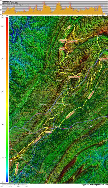
I explored three new climbs today on a somewhat epic 103 mile ride in the rain with nearly 8500′ of climbing. Classes ended last week, and my students finished up their finals online today. With the icy roads and a very busy day of grading yesterday, I decided to take yesterday completely off. That opened up the opportunity in my training schedule to go for a super long ride today. The only thing that didn’t cooperate completely was the weather. Today was much warmer than yesterday with temps in the mid to upper 50s, but it was still quite wet. It wasn’t raining when I left my house, but within 1/2 mile it had started to rain, and another mile later it was a veritable rain shower. Unfortunately, the rain shower was tracking the same direction as the route I had planned out. So I ended up riding in the rain for almost 10 miles straight before it let up. Then it was nice, cloudy, and nearly 60 degrees for the next 40 miles. Then right about the halfway mark of the ride, the rain picked back up again and didn’t stop all the way home.
About the ride – awesome – well, except for all the dogs and the rain. Seriously, as one set of dogs chased, you could hear dogs barking at the next house up the road. The dogs were heavily concentrated in the Annie Lee, Blackjack, Mountain View area. Two of the new climbs were on Pine Mountain just outside of Springville. I had done part of one of the climbs, but never turned to continue climbing the rest of the way to the top. Also, I descended off the backside of Pine Mountain into the valley containing Alabama Hwy 75 near Remlap, and then climbed the backside of Pine Mountain all the way to the Pineview Rd towers. Also, near Clay I climbed Goodner Mountain for the first time. Great view on a nearly bald exposed top (unusual for Birmingham) looking back towards Pine Mountain and Cedar Mountain.
 The view from Mountain View Rd near Springville looking south towards Bald Rock Mountain. Kelly Creek Rd would be in the valley in front of the highest ridge in the distance.
 Heartrate data annotated with road names
 Arriving back home – wet, tired, and reflective
Leave a Reply