Pre-race pic, happy with 65th given this was only my second road event of the year.
Beautiful cool weather this year unlike last year’s scorcher, so hydration was easy. Sad that this will be the last year for Madison hosting the race, but perhaps Northern California hosting it will be a good reason to take a trip out there in 2016. Next year, however, I am aiming for a Southern California trip for the Race Across America. Already starting my training for RAAM 2015, I thought it would be good to do the race and then do a long point-to-point ride while still tired from the race. With my wife’s family in Northwestern Wisconsin, it made sense for me to ride up there from Madison for the rest of our vacation up here.
Race summary
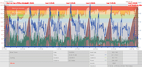
I got a good start near the front, but not having ridden in a pack much this year I wasn’t good at keeping my position as other riders edged beside me. By the end of the neutral section I was already near the back of the field. I felt good on the Cat 3 climb to finish the lap and started feeling more comfortable moving around in the pack. On the third lap, I found myself near the back again when the field slowed down on the county road before the climb. I noticed on the previous lap that the shoulder is very nice, rideable gravel. So I ended up passing almost the entire field in the gravel. In retrospect, I wish I had attacked instead of pulling back into line because there was still a few more miles of slow riding. How epic would that have been to have attacked in the gravel in the national championship road race. Oh well!
Instead, by the time we reached the bottom of the climb on that lap I had already slid back to mid-pack. I was running out of nutrition so I asked Kristine to feed me gels on the next lap. I was near the back the next time through the climb and pulled over to grab the gels. I grabbed them with no problem and chased back onto the back of the field, but by this point the back of the field had splintered and there wasn’t enough of us to chase back on even though we tried an entire lap plus mixing it up with the large caravan of vehicles.
Many people pulled out, but Shawn Gravois (Lupus) and I soldiered on eventually catching Andy Scarano (UHC/706). Together the three of us rolled the last half lap until we caught a few more people coming off the lead group. The last person we caught was near the top of the climb, and he came back around us which was kind of the universal sign that we’re still racing. I took off up the final climb to end up finishing 65th.
 Annotated heartrate plot for national road race (click to enlarge)

Cave of the mounds
After the race, we wanted to check out the cave of the mounds since it was right by the course … an hour long tour was worth it even though my legs were tired and my stomach very hungry. By the end of the tour, we were practically running to the car to get to the nearest place to eat. We ended up at the Grumpy Troll in Mount Horeb. Very good, in-house produced root beer and cheese curds. Mmmmm, mmmm, mmmm.
Adventure in the hills of Southwestern, Western, and Northwestern Wisconsin
After dinner I drove Kristine and the kids on some of the routes through the hills between Blue Mounds and Middleton where we were staying – including Observatory Rd – the views are spectacular. One more trip to Starbucks, and I started this blog while the kids were swimming in the hotel pool. I tried to time my sleep so that I would get exactly 3 hours of sleep (two 90 minute sleep cycles) before getting up. Unfortunately, they were playing a replay of the highlights of last year’s Tour de France so I think I only ended up with one sleep cycle.
“Heading out for a little ride across the state of Wisconsin – 1:15am” – my instagram caption from the hotel elevator as I headed out for an approx 350 mile ride through the hills of southwestern, western, and northwestern Wisconsin.
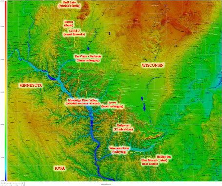
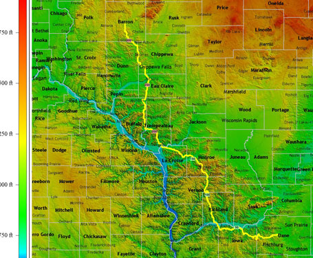
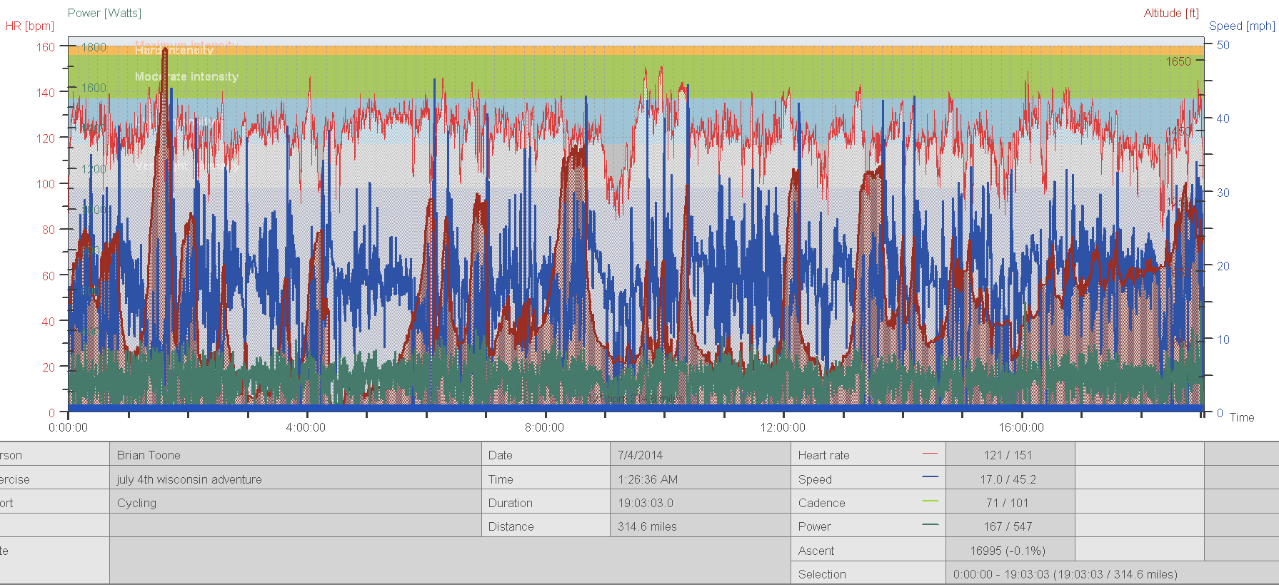
I’ve included my route map below. I tried to pick the hilliest route I could find through all the hills that was still relatively straight heading in the northwesterly direction. There were many climbs I had to skip because they went too far out of the way, but I was still surprised when I was riding at just how many hills and valleys I went through — totaling just over 20,000 feet of climbing. The upper midwest has had quite a bit of flooding problems this late spring / early summer from all the rain combined with snowmelt. This translated to many bridges being out. That makes for quite the challenge on a point-to-point ride. Only two of the bridges that were out were on my direct path. The first bridge out I came to was actually not completely out, and I was able to cross it by hanging off the side of the bridge. The second bridge was really out with no bridge left. I wouldn’t have any problems with taking my shoes and socks off and fording the water, but it was very deep mud and grass that I would need to traverse — not something I wanted to do within the first 100 miles of a 350ish mile ride. The official detour was miles and miles out of the way, so I took an unofficial detour through several miles of gravel on steep rollers, whole fields of bunnies, and endless fields of corn. Some of the other bridges out meant that the larger roads were detouring onto the route that I was already planning on taking. Fortunately, this part of Wisconsin is really rural … no cellphone coverage for over 100 miles from Blue Mounds to Sparta. Then another 100 miles of no cellphone coverage until the outskirts of Eau Claire. So the traffic was minimal pretty much the entire day.
“All kinds of awesome on a point-to-point ride” – my instagram caption at the first bridge out … before holding onto the outside of what was left of the bridge to cross the creek. They had fenced off the bridge itself well enough that I couldn’t just climb over or around the fence.
 western wisconsin – ultra resolution annotated topocreator map (click to enlarge).
 western wisconsin – topocreator county map (click to enlarge). my route traversed 13 counties.
Equipment
I started out at 1:15 in the morning with the moon having already set. The Milky Way galaxy was bright enough to ride through open fields with no lights on! I tried this a couple times on the climbs up to Blue Mounds which have some stretches of open fields. Absolutely amazing. I had a four light setup for negotiating some of the fast descents in the dark – rear taillight, two handlebar mounted front lights (a 200 lumen and a small 50 lumen), plus a helmet mounted 200 lumen headlight. I thought I needed to conserve battery so on all the uphills I rode with just the 50 lumen light on. Then for the faster downhills I turned on the 200 lumen light at its lowest setting, and if the descent really started to turn downhill I flipped on the helmet light at its brightest setting. It turns out I didn’t need to worry about battery at all because this far north, it starts getting light outside by about 4:30AM. By 5AM, you can ride without a light other than a blinkie light for visibility for cars. Plus, sunset isn’t until 9PM with the afterglow lasting until about 10PM!
I also had two Garmins and a cellphone to keep charged during the ride. The cellphone was the most challenging to keep charged because there was so little coverage my phone battery was constantly draining as it boosted the signal to try to find coverage — unsuccessfully. Unfortunately, we had not anticipated so much non-coverage and Kristine was tracking me online. We pretty much gave up on the tracking after Blue Mounds, and I texted her in the two towns that had coverage (Sparta and Eau Claire).
I had split the route into five separate 70 mile courses, which I loaded onto my Garmin 1000. This was my first real course test for the 1000. It followed the courses with no problems, no crashes, no glitches. I know from much experience that my Garmin 800 cannot follow long courses with hundreds of turns without eventually crashing. But since I was doing all the navigation on my 1000, I was able to leave the 800 running without messing with it at all. It made it the entire 315 mile ride without crashing. I had to recharge both Garmins twice. I brought an Anker Astro Mini charger and a Gomadic Solar charger. I completely drained the Anker keeping the cellphone charged but it made it the entire day (21 hours) with a large part of the day spent searching for signals.
The Gomadic I split between the 800 and 1000 and was able to keep both charged although both ended the day with low battery and my Gomadic also with its low battery signal on. Also, in Sparta I knew that I might need extra battery so I bought a wall charger which I also used to charge the cellphone during an extended Starbucks stop in Eau Claire.
Pictures
I’ll finish this post just with some pictures showing the scenery and describing the road as mixed conditions, a lot of smooth pavement with minimal cracking, the occasional perfectly smooth road, some larger cracks on a few of the heavier traveled roads, a few rough gravel roads, and one smooth fast dirt road which I think was being prepped for paving (county ww outside of eau claire). The terrain was steep rolling hills, long gradual climbs and descents in river valleys, plus the occasional long and steep cat 3 climb up to some of the higher ridges. Usually the top of the ridge would be flat to gently rolling with sweeping views of other ridges and valleys dotted with farms, barns, silos, forests … in other words flat out beautiful.
 Western Wisconsin annotated heartrate plot (click to enlarge – look at all the steep hills)
Leave a Reply