I had intended to document my training and everything leading up to my Paris Brest Paris (PBP) adventure a bit more, but life has gotten so busy. I’m going to use this post as a “reverse order” summary of the journey leading up to PBP.
TLDR
Paris Brest Paris is only held once every four years – the “Olympics” of long distance riding. The route changes slightly every year with different checkpoints along the way, but the general idea is a 1200km (750mi) route from Paris to Brest and back to Paris.
Here’s everything you could ever want to know about this year’s race that is “not a race” along with a lot of history from the race that is not a race.
Post-qualifying
Even after finishing my qualifying series of brevets, I have embarked on a few training adventures to get ready for PBP. Since this post is in reverse order, you can read about my qualifying rides in the next section since I finished qualifying earlier this year.
Texarkana Heatwave Adventure – Jul 18-20 2023
Day 1: crossing Arkansas from East to West (269 miles)
My most recent adventure was primarily training for PBP, but it also had a secondary goal of moving me closer to finishing riding in all the counties in Arkansas. I had a little bit of time in my busy summer to get away, but between meetings and other obligations, I had a narrow window which happened to match exactly with the heat wave currently blasting a good chunk of the country.
I went to sleep at 7:30pm, but was up by 10:30pm and out the door by 11pm to drive 4 hours to Helena-West Helena, Arkansas. I was parked and riding by 3:3AM and was flying on a very flat Hwy 49 averaging 19mph and thinking “no problem, I’m going to knock out 380 miles in well under 24 hours”.
Five miles into my ride, I saw on my Garmin that I was supposed to turn and remembered that I had routed myself on a google maps “solid green” bike trail, which used to mean that it was a paved trail. Well, after turning too early and heading way down quite a ways down a driveway (when I should have been down in the old railroad bed), I had to turn around and make my way back and across the railroad bridge and then down the gravel parking lot to a most definitely not paved (gravel with large rocks) trail. Still, I knew it wasn’t long so I went ahead and rode it anyway.
After a couple miles, I was happy to leave the trail (and gravel) behind. Or at least that’s what I thought. I left the trail and headed across a major highway onto the next road which turned to gravel almost immediately (oh no!). I’m not afraid of gravel, but with nearly 700 miles left to ride, I had to ride it very carefully to avoid getting a flat so early in the ride. So my average speed went from 19mph down to a whopping 13mph by the time I finally made it out of the gravel almost 10 miles later.
The gravel road went through a lot of farm fields and crossed a few creeks and alongside others. But it was at night so I was focused mainly on picking a line in the dark with the glow of my headlight on its lowest setting to avoid the sharpest and largest rocks. Eventually I popped out onto AR-1, the first of many state highways that I would ride. I started making good time again, and had my average speed back up again in no time.
But within a few hours after the sun came up, I would find myself entering “Texarkana, Texas” into google maps to find the straightest route to where I had already booked a hotel to spend the night. This ended up cutting off 110 miles of the route that I had planned, which would have taken me farther northwest into the Ouachita Mountains.
People at the gas stations were friendly and absolutely amazed that I was out riding in that heat. I thanked them and assured them I was just riding from gas station to gas station to take a lot of breaks. My route deviation had me on a lot of nice state highways. Arkansas does their state highways very well (or at least the several hundred miles of them I was on were all perfect) with great pavement, broken rumble strips (with gaps for cyclists), and wide shoulders. AR-46 between Sheridan and Leola was a great example. There was so little traffic on a perfectly paved and quite hilly (for the area) road.
The afternoon heat did not relent at all and even after the sun set, it was still hovering around 90 degF for a long time. Shortly before midnight I made it to my hotel on the Arkansas side of Texarkana, but I still had to go another quarter mile to officially cross the state line into Texas. No problem, except the hotel was on a one-way frontage road, which meant I had to ride extra to be sure to cross the state line, and then ride backwards on the one-way. Thankfully since it was almost midnight there wasn’t any traffic.
Day 2 : crossing Arkansas from West to East (294 miles)
I knew as I got closer to the end of Day 1 that I was facing a bit of a dilemma. My normal strategy is to leave early evening so that I can ride 10-12 hours at night and finish the last 6-8 hours during the earlier part of the day with the worst case of finishing early afternoon. But that was the problem, I wasn’t even going to arrive at the hotel until several hours after the time I’d normally like to start riding during the summer!
The best I could do was start riding again by 3am, which means riding the entire daylight hours. So I set my alarm for 2:30am with the hope of leaving by 3 or 3:30 at the latest. Instead, I slept right through that alarm (it was on vibrate only) and didn’t even wake up until 5am. This worked out well because I am glad I got to ride in my favorite part of the day (sunrise) and decided by lunch that I could find a place to take an afternoon nap somewhere and then get started again around sunset and ride through the night.
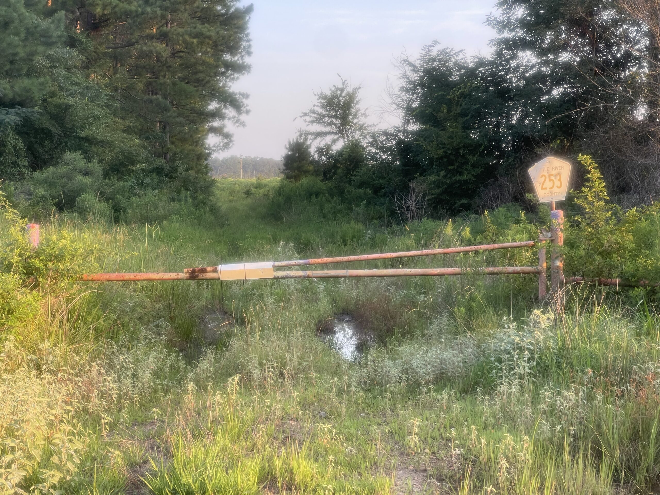
The question I was trying to work out was route I could take so that I wasn’t just riding the same roads back to the start. I mistakenly trusted Google Maps to take me to a few intermediate points, and it didn’t take long before I was three miles into a gravel road staring at a “Dead End – Private property – No turnaround – This road does NOT go through” homemade sign. So I turned around because I had passed a few other turns, but the ones google maps tried to re-route me through was a long abandoned county road above (at the top of the post). On my Garmin with popularity routing turned on, it looked like a well ridden road which made me wonder if it was on a bikepacking route.
So not one, not two, but SIX bonus, gravel miles later, I found myself back on Highway 71 at the same spot where I had just been. A few miles later I was able to get breakfast at a McDonald’s in Ashdown, Arkansas and load up on ice and make my way across a large dam of the Saline River creating Milwood Lake. This was followed by a fun, long, rolling climb up to Saratoga.
By the time I had made it up through Nashville and Murfreesboro it had started to get quite hot. I started struggling a bit and stopping at all the gas stations again. It was around here that I decided to start looking for hotels to take an afternoon “siesta” and found a great hotel in the Caddo Valley outside Hot Springs.
It was perfect and much needed. My Garmin had climbed up to near 110 degF in the sun. When I woke up a couple hours later and left, the temp was still in the 90s, but with the sun low enough in the sky before sunset everything was covered in shade as I rode. It was wonderful, my favorite part of the entire trip – the section of US Highway 67 from Caddo Valley to Malvern.
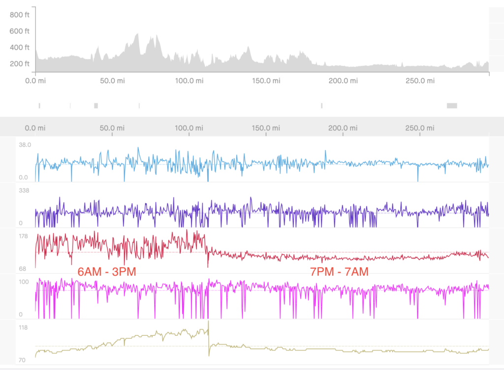
It stayed hilly for a while but it eventually flattened out. I wasn’t sure what I would find open in the middle of the night so I loaded up and carried extra gatorade. Thankfully I never ran out as the temps had dropped down finally into the lower 80s and upper 70s. It was interesting looking at how much harder my heart had to work during the day in the heat as opposed to the nighttime riding. Check it out on the distance-based graph below:
Towards the middle of the night, I realized that I was not going to finish before sunrise. And as the miles dragged on, I dreaded that it would get hot again before the end. But thankfully, I made it back to Helena shortly after sunrise. I then had to make the hard decision to pass by the car and drop down to the river so I could ride across the Mississippi River on one of the few bridges I still had left to cross. This was a quite narrow bridge given its distance over a mile wide with a very tiny shoulder. Thankfully, it was pretty quiet and only a couple big trucks passed and not at the same time or with any opposing traffic.
NC/SC gator hunting – June 19-20 2023
This adventure had a dual purpose – more training for PBP and to finish riding in all the counties in South Carolina.
Qualifying
To qualify for PBP, one must complete the full randonneuring set of distances (200km, 300km, 400km, and 600km) as official, organized brevets in the calendar year of PbP – so for me: 2023. I was fortunate to ride all of my qualifying events here in Alabama thanks to the amazing organization of our local randoneurring club, Alabama Randonneurs led by Chris Argo.
The Blackbelt 600K (600km) – Apr 23 2023
Here’s a quick summary I wrote on Strava: it was an amazing route. Lots of adventure, too, climbing two fire towers and the train lift bridge. Very cold by morning after starting after midnight and then was caught completely off guard by the cold rain storms that moved through after sunset on Sunday. “Rain” was most definitely not on my bingo card for Sunday, so I hadn’t brought any of my rain gear. I was wet and cold, dried off for a while at a gas station, bought a poncho at the dollar general next to the gas station in Thomaston. And of course it stopped raining after buying a poncho – it literally was raining when I went into the store and completely stopped when I came back out … I was in the store for less than 5 minutes. I called my wife and told her I could control the weather, lol.
Horse Pens and a Legend (200km+) Mar 25 2023
Summary from Strava: my Original plan was to leave the house by about 3am and ride for 4 hours before the start and then add on another 4 hours after the ride to knock out 256 miles (Eddington 256 goal)… but thunderstorms had other ideas. It didn’t stop raining until about an hour and a half before the start of our ride. So I decided to scrap the 256 and just ride straight there and straight home.
Birthplace of the King (400km) – Mar 18 2023
And here’s a summary from Strava on this one: “Headwind for first half, tailwind for second half. Cars (and dogs) timelapse video: https://www.mybiketraffic.com/rides/view/36017 … oh, I should also note that about 10 miles from the end I decided to set my final lifetime Eddington goal at 256. I mean if you think about it, my life has been so much about computers and bikes so 256 is perfect. I had to add on a couple of very cold, windy miles to hit 256. That’s what is beautiful and devious and challenging about Eddington. See my progress here: https://eddingtonmap.com/view/1“
More about my Eddington goal in the comments: “i’m crossing stuff off my bucket list right now because having come very close to dying twice already, you take a huge gamble in setting an eddington beyond reach because all those extra miles you didn’t want to ride take away time from family, friends, and work leading to a more stressful life and you have a higher probability of not making the goal. Now that I’m sitting at 207, I do regret having originally set it far too low (200). I think 256 has meaning outside of biking to me and it pushes me a little bit farther that 250. I won’t stop riding at 256 if it makes sense to keep going. But by setting the goal at 256 now, it makes me add on a few miles at the end of every 250 ride instead of having to add on 25 or 50 miles (275 or 300), which can be unbelievably hard and undesirable. I mean, realistically, I could do one 300 mile ride per week for six years in a row and have an E-300 from scratch. But by setting an E-256 now and trying to incorporate it into my every day life and my normal riding adventures, it will make that push to 300 that much easier if I live that long. That’s my rambling thought process on this.”
Spring break adventure cut short Mar 3-8 2023
This ride turned into great logistical practice for the logistics surrounding PBP. Here’s the setup: I had the entire week off and both weekends free, but I had an important meeting smack dab in the middle of the week on Wednesday.
On top of that, we decided a couple days ahead of time that I should bike up to meet my daughter driving home from college because of a run-in with a deer on her last drive to help her with the drive home from Viriginia.
The scene is set.
I decided to leave Friday afternoon after work to drive over to Columbia, South Carolina to start riding by about midnight. I originally had a second route I was going to do leaving the next morning and heading the other way. But with needing to meet my daughter on her drive home, I had a dilemma.
I could make it from the hotel up to her route no problem, but the real problem was then it was going to be close to 375 miles to get from my home in Birmingham, Alabama back to the car in Columbia, South Carolina which was going to be tricky with my other timing constraints.
So the solution was to drive the car west towards Birmingham and spend the night at a hotel in Madison, Georgia, leaving the car in their parking lot, and riding north to meet my daughter on her drive home. Then I could spend the night at home and bike pack to the car, to then drive back to Columbia to do the second ride I had planned for South Carolina.
This worked perfectly except for two things. First, the hotel was under massive construction project and only had about 10 parking spots that weren’t occupied by construction vehicles. So after checking out of the hotel, I needed to move my car and found a huge Lowe’s parking lot to leave it in. Second, the roads I navigated myself on were somewhat awful to get from Madison, Georgia to Chattanooga, Tennessee. Georgia is normally better than this, but there was one state highway that had a full, unbroken rumble strip taking up the entire shoulder for many miles. I believe it was GA-36 from north of Ball Ground to where I turned off it a good while after Carter’s Lake. This was a BUSY highway taking me up into the mountains.
Still, despite a few close calls, fast drivers, mean drivers, and weather starting to get surprisingly hot for this early in the year, I made it to Chattanooga and was happy to meet my daughter at Fazoli’s before driving back to Birmingham.
I didn’t sleep long, though, when I got home so that I could try to make it back to Madison, Georgia early enough to then leave early enough again to have a reasonable time amount left to get back to my meeting back in Birmingham on Wednesday.
The ride from Birmingham to Madison ended up being close to 260 miles, and I made all the way through downtown Atlanta during rush hour traffic. This was not a problem as the bike lanes and infrastructure was fantastic until I made it to the far suburbs where traffic was still heavy and you lost bike lanes and shoulder to ride on. It didn’t last long, though, before I made it onto quieter roads and eventually a couple hours after sunset back to Madison, where I then had to put my bike back in the car in the Lowe’s parking lot and drive an hour and a half back to Columbia where I had a room reserved.
A few hours later, I was up and out the door again for one last 270 mile ride which I summarized on Strava this way: “This ride was fantastic. I saw that there was all kinds of wind advisories for the day BUT I also noticed that the wind was going to be shifting literally the entire time I was riding. I was hoping it might end up being a full infinite tailwind loop. But here’s how it turned out instead … moderate head/crosswind turned into a tail/crosswind which continued to get stronger. As I made it farther east on the top part of the loop, the crosswind kept getting strong but my route also took a dip farther southeast so that it was back to a tail/crosswind. Then that big southern dip on the far eastern side of the route was a nearly perfect tailwind at maybe 20+mph. The sun set as I turned back west and that seemed to make the wind die down … but it picked back up as a strong tailwind as I headed south down into Columbia area. One final surprise was my bike navigation trying to take me back across the river through the zoo … so I opted for the interstate instead. I went with I-20 and it had a super wide shoulder … even on the bridge! It felt safer than many of the roads I had been on all day.”
The Prattville 300K (300km+) – Feb 18 2023
It was a very cold morning with temps down into the 20s for my 75 mile ride down to the start. I had a bit of a tailwind on the way down which helped with the temps (reduced windchill). Still, I stopped at a gas station about 5 miles from the start and drank coffee for a good 10 minutes trying to warm up before I had to leave to ride fast the rest of the way to make it to the start on time right at 6am.
I left with the group, but got ahead on the first long downhill and decided rather than waiting to just go ahead and drill it since I was already warmed up and kinda in a rhythm at that point. It was a bright, sunny, but windy day. This turned out to be OK, though, because I watched and laughed in amazement as the wind shifted throughout the course of the day such that I had a tailwind on the way back home by the end.
A lot of the roads were new to me, especially south of Montgomery riding through swamp forests, even, which were amazing in the morning sunlight.
It was a bit of a race to make it back to the high school where we started before sunset and I made it (barely!)
Tornado damage from the tornado that had happened a few weeks earlier caught me by surprise. I ended up riding through it four times. Once on the way down, twice during the brevet, and once on the way back.
Here’s a video timelapse of the entire ride (but only while the radar was active from cars passing) – https://youtu.be/VTvlZLf0yaI
Off the bike
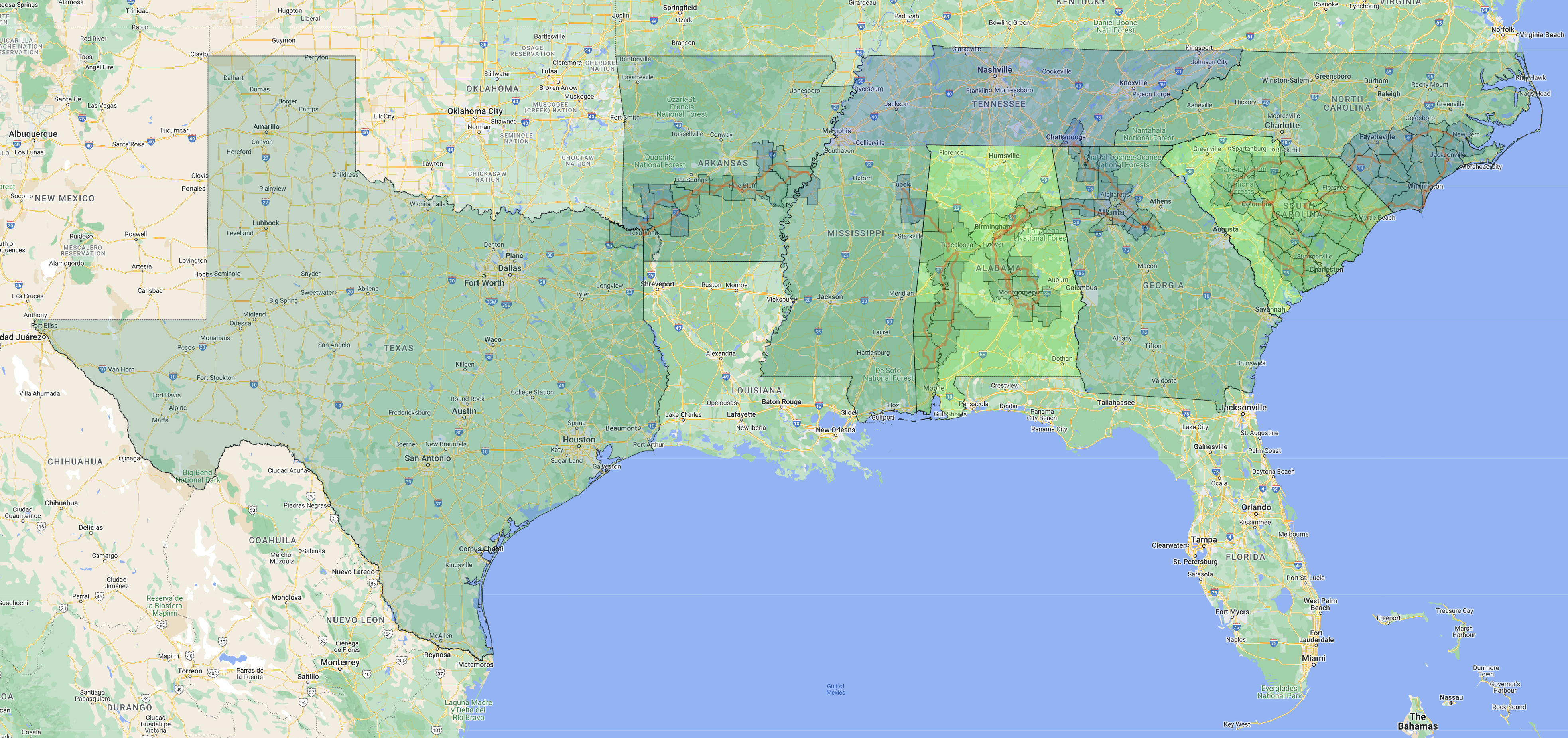
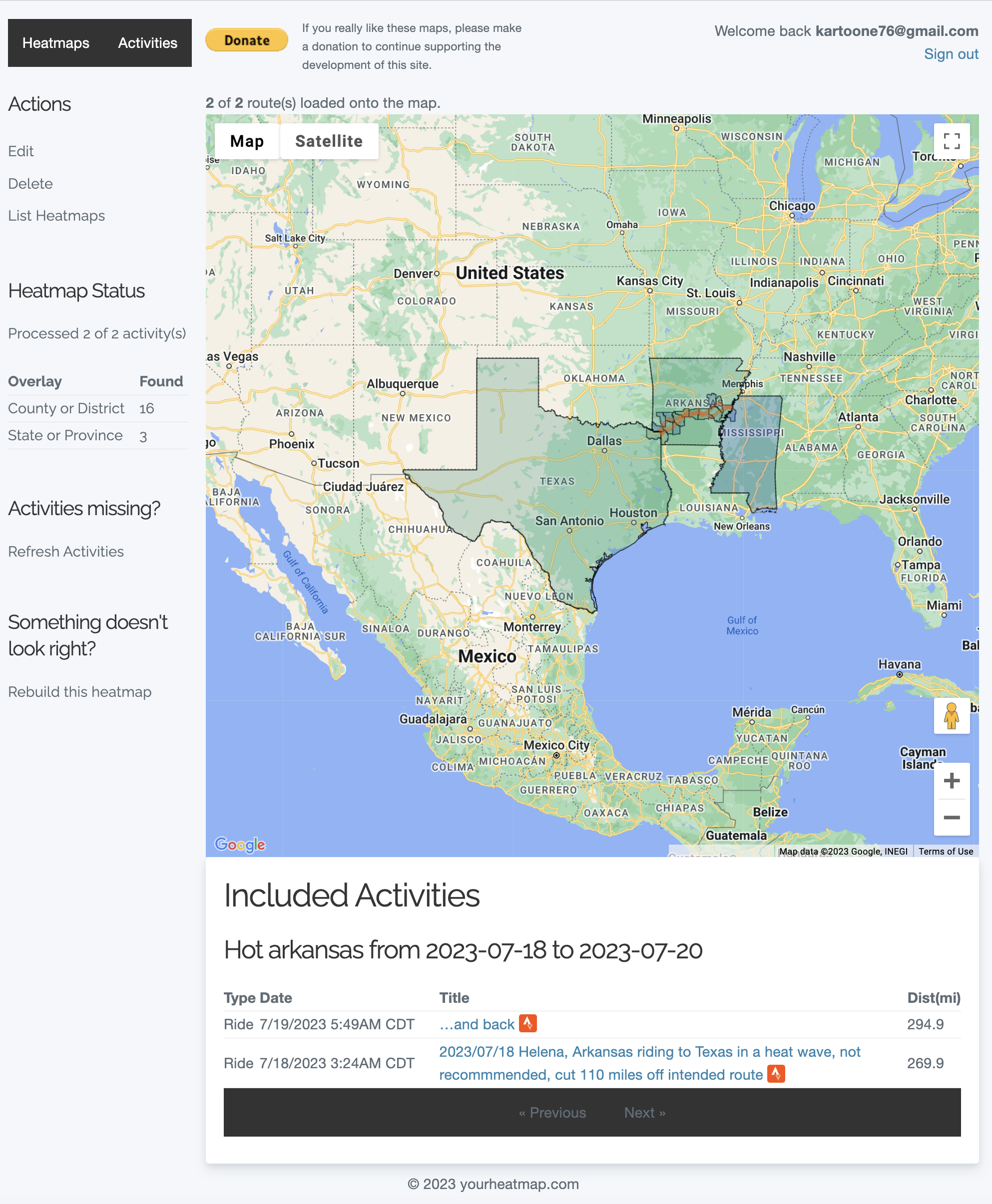
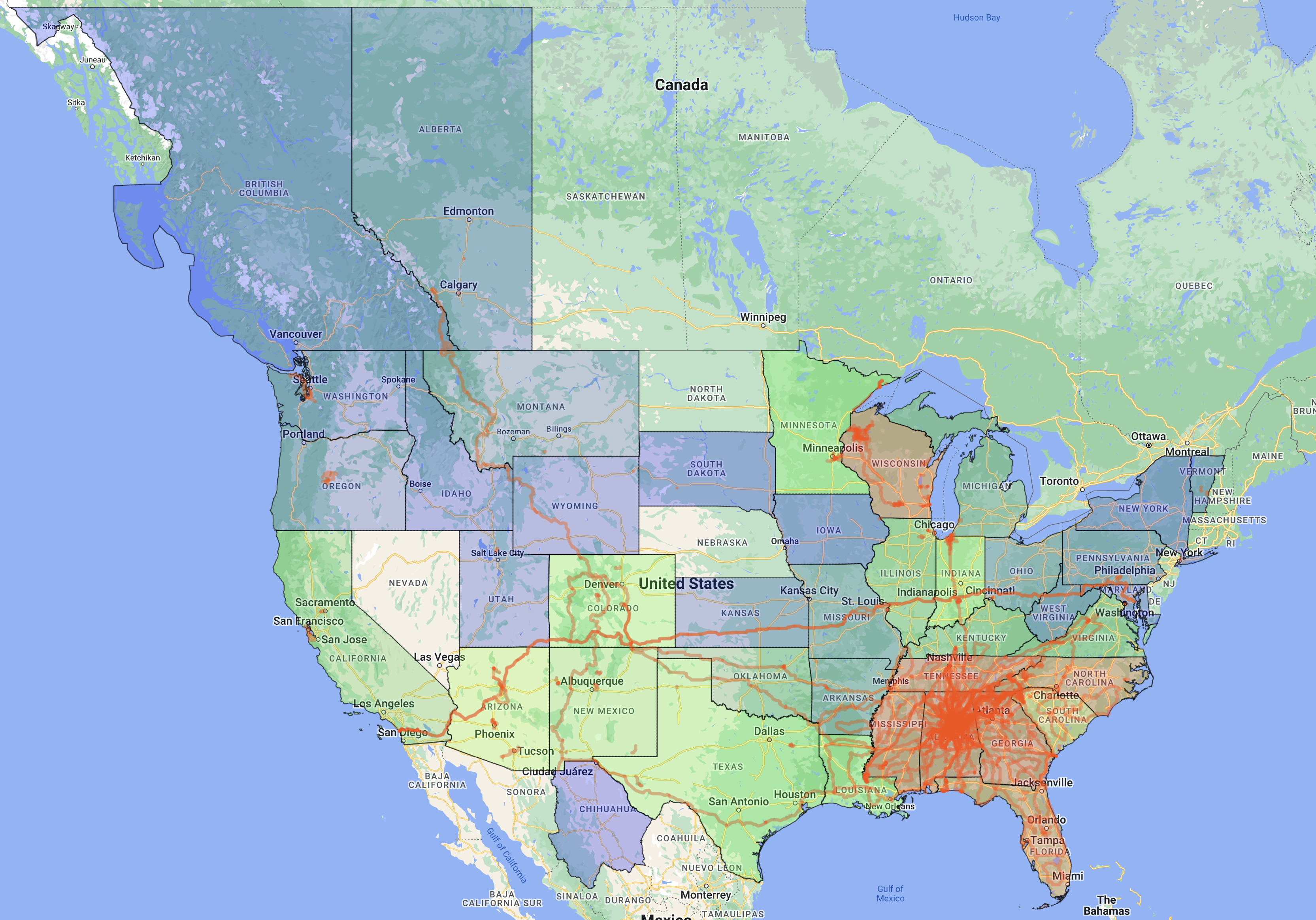
As mentioned at the beginning, life has been so busy. I’m working on a number of projects with mybiketraffic really taking off and becoming a key part of my research career at Samford. But apart from that with my love of maps and places, I started yourheatmap.com to bring my heatmaps I’ve been creating for years now to other people. If you click on the link and create an account you can start using it but know that probably still has many bugs and please make a donation as storage space is expensive (I just spent another $300 on a 20TB hdd). I’ve included a few of my most recent heatmaps below, including this first one which is a map of just my “Road to Paris” rides I’ve written about on this blog post. Enjoy!
Leave a Reply