 The beautiful view as soon as I arrived at the cabin near Dahlonega.
I spent a weekend of riding and racing in the North Georgia mountains. The Southern Cross race was on Saturday morning (awesome race – read my recap here), so I drove up on Friday. More specifically, I biked to work Friday morning, taught two classes, biked home, and then drove 4 hours to a cabin at the base of the Woody Gap climb just north of Dahlonega. There was still about a couple hours of daylight, so with the excitement of being in the middle of all the beautiful mountains, I got my bike out of the car as fast as possible, changed clothes right there beside the car, and went for a 2 hour ride climbing Woody Gap twice from the south side and once from the north side (much shorter climb) making it back to the cabin just after sunset. So that made for three bike rides and one four hour drive all in the same day.
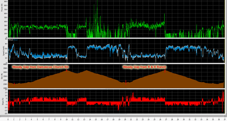
Here is the iBike data for the two Category 2 (Strava) climbs –
------WOODY GAP (from Damascus Church Rd) ------
Strava:      Cat 2
Dist:        9.00 mi (0:41:38)
Climbing:    1816 ft
          Min   Avg    Max
Power       0  260.1   387  W
Gravity  -520  163.6   485  W
Speed     6.9   13.0  35.2  mi/h
Wind     12.6   17.1  34.1  mi/h
Elev     1514   2272  3242  ft
Slope    -5.9   3.67   8.4  %
HR        133  145.7   159  bpm
NP 264 W; IF 0.951; TSS 62.7
2/25/2011 3:37 PM
56 degF; 1017 mbar
------WOODY GAP (from R & R Ranch) ------
Strava:      Cat 2
Dist:        6.71 mi (0:30:43)
Climbing:    1651 ft
          Min   Avg    Max
Power       0  289.9   608  W
Gravity -1127  202.6   483  W
Speed     0.0   13.1  39.6  mi/h
Wind     12.5   15.6  35.2  mi/h
Elev     1673   2433  3265  ft
Slope    -8.4   4.50  16.1  %
HR        107  156.2   178  bpm
NP 302 W; IF 1.088; TSS 60.6
2/25/2011 4:43 PM
49 degF; 983 mbar
And here is the graph for the entire ride:
 iBike data for the entire ride.
Sunday’s ride was even better with me accomplishing what could be considered a dream of mine from over 15 years ago when a friend of mine asked if I would ride 200 miles with him in preparation for a tour across America that he was going to be doing. Well, he ended up having to back out, but I went ahead and completed the 200 mile ride from Clemson, SC to Brasstown Bald (highest point in Georgia) and then back through the Highlands, NC area. The only problem was that Brasstown Bald summit is not accessible by bike during the peak visiting times. You can either hike up to the top or take a shuttle. But they specifically disallow people from biking to the very top of the mountain. You can bike to the parking lot which is about 350 feet below the true summit, but you cannot bike to the top. I tried three years in a row at the end of each racing season, but I would always get chased down by the park workers. Well, guess what? In the middle of winter, the shuttles don’t run to the top, so you can bike up without any problems at all!
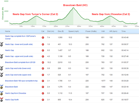
So I left our cabin early on Sunday morning, biked over to US 129 and climbed Neels Gap before turning onto GA-180 and climbing Jack’s Gap before turning at the top onto the 180-spur which takes you up three very steep miles to the highest point in Georgia. The ride started out kinda blah because it was really humid and warm when the sun was out, but cold whenever the sun went behind a cloud. So I kept on breaking out into a sweat and then getting cold. Plus, my legs were pretty cooked from the Southern Cross race the day before. But as soon as I made it to the Brasstown Bald parking lot and saw that the shuttles weren’t running, I knew that I might just have a shot at making it to the top – and I did! Strava categorizes the climb as an HC climb. Here is the elevation and gradient graph from Garmin Training Center:
 Brasstown Bald elevation and gradient data.
And here is the Strava stats on the climbs (Neels Gap 2x and Brasstown Bald):
 Strava data for the Brasstown and Neels Gap climbs.
And here are two pictures from the summit of the climb:
 View looking south from the summit of Brasstown Bald.
 The Tour de Georgia queen stage always finished on top of Brasstown Bald.
After having the opportunity to finally make it to the top of Brasstown Bald, I immediately forgot about how bad I had been feeling and thoroughly enjoyed the return trip back to the cabin before driving home to Birmingham. Also, I stopped at Turner’s Corner store on the way back and got to talk to the owner, who is on the Six Gap Century committee. His gas station and convenience store is the first rest stop for the Six Gap Century, and there is a corner of the store that is dedicated to biking with all kinds of biking equipment. What a fun adventure in the beautiful North Georgia mountains.
Here are more pictures from the rides on Friday and Sunday:
 FRIDAY – The view ahead on the Woody Gap climb – notice the slope on Columbia Mountain!
 FRIDAY – The view looking down towards the R & R Ranch from about halfway up the climb.
 FRIDAY – View from scenic overlook about halfway up looking north towards Blood Mountain.
 FRIDAY – The view from the top of Woody Gap looking back down the mountain towards Dahlonega.
 FRIDAY – The top of the Woody Gap climb (from the South)
 FRIDAY – Cadets from the Military Institute practicing repelling and climbing.
 FRIDAY – Blood Mountain (Neels gap just to the right) – view from our cabin.
 SUNDAY – Waterfall on the side of US 129 climbing Neels Gap
 SUNDAY – Looking back down the switchbacks on US 129 climbing Neels Gap
 SUNDAY – Appalachian Trail sign on Blood Mountain
 SUNDAY – Blood Mountain informational sign
 SUNDAY – in the valley after descending from Neels Gap looking towards Brasstown Bald
 SUNDAY – the 180 spur entrance that starts the final 3 miles to the top
 SUNDAY – view of the lookout tower at the top after the steepest part of the climb
 SUNDAY – horseshoe switchback not too far from the Brasstown Bald parking lot
 SUNDAY – Brasstown Bald informational sign
 SUNDAY – up close view of the lookout tower
 SUNDAY – Beautiful waterfall on the reverse climb of Neels Gap
 FRIDAY – The view looking over at Gooch Mountain – our race the next day would be coming back down on the other side of this mountain.
 SUNDAY – The top of Neels Gap
 SUNDAY – the Appalachian Trail starts on nearby Springer Mountain, so I imagine these boots hanging from the tree must be from people who have hiked the entire trail!
Leave a Reply