Frozen Niagra, Mammoth Cave, Kentucky
Now that I’ve wrapped up just about everything for Race Across America this year – except for the poster-sized topocreator maps I’m sending out to supporters – I’m going to switch back to this blog for updates on my cycling adventures. Yesterday’s 326.3 mile, three-state ride in Alabama, through Tennessee, and into Kentucky definitely qualifies as an adventure. The reason for this adventure was to meet Kristine and the kids on their way back from Northern Indiana, where they had been visiting family.
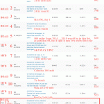
 Topocreator.com county map showing the 5 counties in Alabama, 9 counties in Tennessee, and 2 counties in Kentucky for this ride. Click to enlarge and then click again or pinch zoom to see the details of the map.
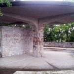
On the bus taking us to the cave entrance for the Grand Avenue tour – 4 miles of trekking underground. Fun hike with lots of tired legs by the end.
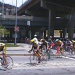
I’m just realizing that the only time I had ever ridden in Kentucky before this ride on Tuesday was in national championships. The first was back in 1998 in the espoir (U23) national championship. The road race circuit started in downtown Cincinnati, but crossed the Ohio River into Kentucky. Some of the pics I took with my first digital camera from that race are in the gallery below.
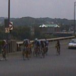

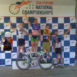
The second time I’ve ridden in Kentucky was for the 2010 Masters 30-34 National Road Race. I missed the winning break with Jonathan Jacob but ended up breaking away from the pack on Tunnel Hill and bridging up to John Delong, who had already gotten away on the previous lap. The two of us worked together for the next few laps and stayed away from the pack to take 4th and 5th – my best result in a national championship.
The beginning
It’s hard to even know where to begin with describing this ride so I’ll give a blow-by-blow of the highlights. I left home at 12:30AM and climbed up to the high point on Vestavia Dr overlooking Homewood and Birmingham. Even at the top of the climb, I hadn’t decided exactly how I was going to get over to AL-75, but I knew that was my first destination since it is a long, flat four-lane highway with very long sight-lines for spotting drunk, sleepy, and/or inattentive drivers. I ended up sticking with the original route I had planned, but not committed to yet, which was to climb back up 280 to Cherokee and over to Old Leeds. I was worried about Cherokee because of the very short sight-lines and it being only 1AM the very really possibility for people coming home from bars. I had planned this route because I knew I could cross the seven lanes of highway 280 safely at 1AM, whereas it’s nearly impossible to do that climb from Lakeshore during the day anymore because of the change in the light at 280.
Cherokee was fine, and Old Leeds was fine. John Rogers was great since it is lit up with those super bright lights. I rode the 3 mile stretch with my lights off to conserve battery, and since it is practically daytime under those lights. The short stretch of highway 11 was good, and Edward Lake was unusually deserted (I usually get passed by a couple cars no matter the time of day or night). AL-75 was good and fast bringing my overall average speed up from about 15mph to 18mph even with all the climbing at the beginning of the ride.
The legend of sleepy hollow
When I made the turn onto Co Rd 15 to cut over to Locust Fork, I knew that this ride was going to be something special. The moon was bright enough to see by for a few sections, but it was low enough in the sky that once I hit the hollows past the gap, it was very dark and very quiet. Zero cars passed me through here. This continued all the way through to AL-79 and on up to Cleveland. There was nobody out, and I mean nobody. This made for a scary first time crossing of the Swann covered bridge at night. I was fine riding down to the bridge and across it, but the climb out the other side is steep. It didn’t help that breaking the silence as soon as I crossed the bridge was a gunshot. It wasn’t nearby, but it startled me and I flew up the climb imagining a headless horseman chasing me and wondering what speed it could go up the hill versus how fast I was going. I got the KOM on the 1.1 mile climb over 3 minutes faster than the previous KOM.
Once I made it out onto Joy Rd which cuts over to Blountsville, I relaxed able to see a bit better and also making it past the huge sheepdog that is at the top of the Swan bridge climb. I saw a shooting star and then came really close to the gunshots I heard earlier. I don’t know if they were spotlight hunting or just having fun at almost 4AM in the morning, but whatever they were doing it was awfully close to the county road.
My first planned course ran out after Blountsville, but my Garmin was so wet from the humidity and dew that I couldn’t get it to start a new course. Everything was still closed at 4AM so I had to dig through an outside trash can at a closed gas station to find something dry to wipe off my hands and the Garmin screen. Everything I had with me, every piece of clothing, and even everything inside my camelbak was wet. And this is without it even raining. It was just 100% humidity with a very heavy dew with intermittent fog.
By the time I made it up into Cullman County it was approaching 5AM and the commuting traffic was starting to pick up … they have a long ways to drive to get to Huntsville or Birmingham. It was bearable because by saying “traffic picked up” I mean one car every 5-10 minutes instead of every 30-60 minutes, but also disconcerting because some of the stretches through here were quite foggy. I have a lot of reflective clothing and reflective tape on my bike and backpack. So my trick is to stand up and rock the bike side-to-side vigorously to make everything reflective move quite a bit. You can always tell the moment that the car sees me because they let off the gas.
It was still before daylight when I hit the Apple Grove descent, which was the second major destination guiding how I was routing myself up to Huntsville. I had done the corresponding climb in the reverse direction several times, but never the descent. I figured it might be a 60mph descent, straight-as-an-arrow, and that’s what it felt like on the way down because of the low light before sunrise, but when I looked at the Garmin I had maxed out at 56mph. It must have been too much flapping of the backpack.
Across the short valley at the bottom I ran out of water just before the start of the climb up Apple Grove Rd on the other side of the valley. This is the reverse direction of the 2013 state road race course. I knew from that race that there was no water to be found anywhere nearby so I chuckled wryly that the only positive thing about running out of water in the middle of nowhere was that I could go for the KOM – so I did. I went hard and ended up 3rd on the long, steep cat 4 section at the beginning of the climb, but managed to get the KOM on the even longer cat 3 version all the way up to the very top of the climb at Union hill.
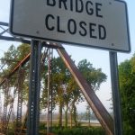
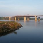
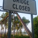
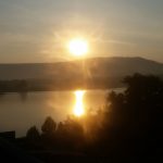
I knew the next water I would find would be on US-231 at the top of the hill, but those gas stations (two of them) were still closed. I went ahead and did the descent in moderate traffic and stopped at the gas station at the bottom, which was open. By the time I had gotten everything done I needed to do, traffic was really picking up as Highway 231 is the only bridge in the area for many miles that crosses the Tennessee River. The sunrise was spectacular, but my camera was so fogged up from the humidity that I couldn’t get very many good pictures off the bridge or crossing the abandoned bridge over to the greenway:

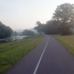
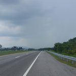
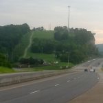
Once I made it all the way to the end of the greenway, it was 7:45AM and I was still heading into downtown Huntsville but traffic was surprisingly light. Out of town, I did the climb up Governor’s Boulevard hopping off the road onto the shoulder whenever a pack of cars from the stoplight at the bottom would approach. This was fine, although I wouldn’t recommend doing this on a regular basis. I wanted to do that particular climb because I noticed that you could descend down onto Dug Hill road and then take that over to Gurly. This section of North Alabama through New Market to the Tennessee border was flat and fast with a slight tailwind. I had my average speed all the way up to nearly 18mph again even including the two gas station stops I made in Huntsville.
Thunderstorm dodging
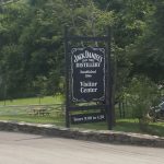
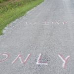
It was getting very hot, so I stopped at the first gas station I saw and refilled before heading up into the Tennessee Hollows where I knew gas stations would be few and very far between. I wanted to pass through Lynchburg where they make Jack Daniels and dodged my first thunderstorm there by simply slowing down and watching the rain cross the road in front of me. I didn’t think it would show up on the video, but there was a section of road where you could see that it was raining on the road a couple miles ahead, but not on the left side of the road. So I relaxed and soft-pedaled for those couple miles and by the time I made it there it had stopped raining. Past Lynchburg I turned northwest away from the storm and ended up following some sort of marathon course with lots of markings on the ground including “only wimps walk here”, “5k to go, start your kick”, “wrong way”, and directional signs.
By the time I ran out of water again, I had made it to Wartrace, TN and I could see another big thunderstorm directly in front of me. I had an extended lunch and waited for it to also cross the road. When I left the gas station, the first storm had passed, but I could see another one approaching just behind it. I rode really hard for about 20 miles to end up perfectly hitting the slot between them without a single drop of rain although I rode on some wet roads because of the first storm. Then I made a 90 degree turn and rode east on US-70 towards Woodbury and was about to run into the back of the first storm. So I stopped to take a couple pictures off the side of the road. And the two minutes I was stopped was enough time to let the storm advance through Woodbury. At the end of the gallery is a pic of why I stopped at a Rite-Aid in Woodbury even though I still had plenty of water and was turning north away from the storm that had just passed in front of me.
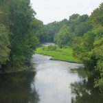


Past Woodbury, I turned north thinking that I would be able to make it in front of another storm, but I ended up taking a detour come in behind that storm. This detour led me to a spectacular road near Pleasant Ridge. It was rough across the top at first, but then the chip/seal was older and smoother. I was getting excited about the divebomb descent back down into the hollow and tucked for the descent when I noticed at the last second that the pavement ended. I slammed on the brakes mainly because I wanted to get a picture of the transition but I couldn’t stop until well down the hill. I hiked back up (no way to get started on the gradient in the gravel). The gravel descent was amazing – all the rocks were cleared off the double track and you could absolutely fly down it. There was a couple washboard sections at the runout on the bottom, so you had to brake for those. The valley this gravel road went through was really fun, rural, and fast.


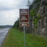
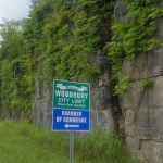

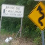
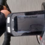
After climbing up through Defeated and Difficult, I went through the town of Red Boiling Springs not too long before hitting the Kentucky border. A few miles later I stopped at a gas station one last time having run out of water for the third time, which is so ironic given how absolutely wet I was all day – water, water everywhere but not a drop to drink. It didn’t matter, though, I was still having a blast 300 miles into the ride and made it the last 25+ miles into Glasgow with no problems on some really fun roads – the theme for the day.


Animals seen
- Fox crossing the road near Locust Fork.
- Dead baby skunk.
- Baby raccoon.
- Very fat squirrel.
- A few hawks.
- Blue herron.
- On the climb up to the Cordell Hull Lake overlook, I was staring down at the white line on the side of the road and glanced up just in time to see a mother deer and two small fawns standing very still right next to the road. I had just about got my camera out of my pocket when they took off up the hill next to the road. I was no more than 6 feet away.
Leave a Reply