When I was exploring the Birmingham Monsters on Wednesday, I knew that I didn’t really have time to go out and hit up my favorite monster in Birmingham – Double Oak Way. So today the opportunity came up to ride out that way and report on the stats of three more monsters and one more mini-monster in the Greater Birmingham area. This ride was on my commute home from work with a backback on so I would think you would have to consider these part of Birmingham if I can include them on my commute!
 The Birmingham Monsters, southern edition, complete ride.
 3D View of the Hugh Daniel – Brae Trail and Double Oak Way Monsters.
 3D View of the Hugh Daniel – Greystone Crest and Double Oak Way Roller Coaster section.
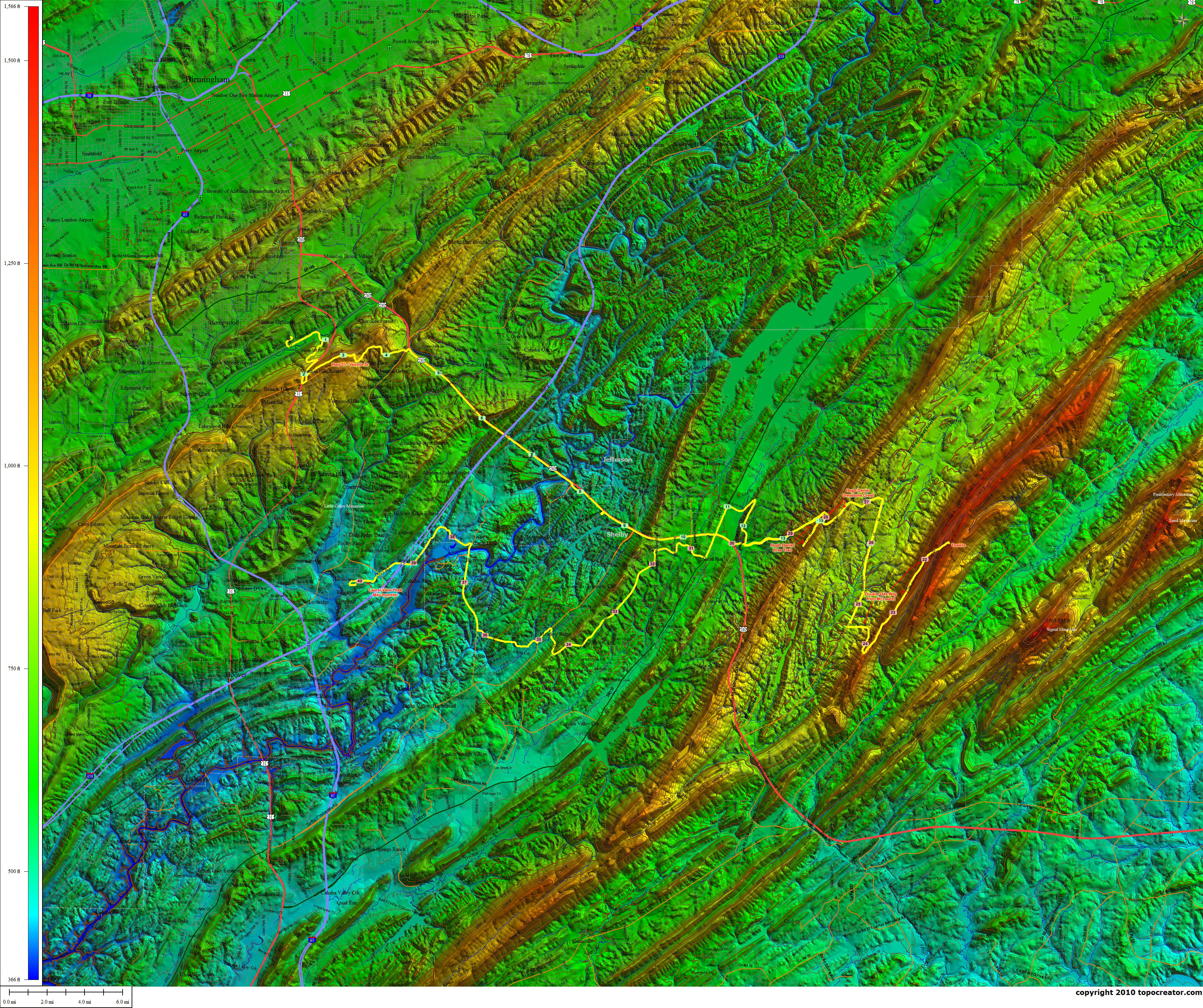
 Annotated topocreator map of the southern monsters. Click here to download a huge detailed version.
For the climb statistics, first, here are the Scanuppia Factors for the three new monsters…
Hugh Daniel Brae Trail –
0.26mi (0.06mi@19%, 0.06mi@17%, 0.14mi@17.8%)
Double Oak Way –
0.42mi (0.14mi@17.1%, 0.09mi@18.3%, 0.05mi@17.1%, 0.14mi@17%)
Hugh Daniel Greystone Crest –
0.11mi @ 17.1%
 Hugh Daniel Brae Trail Monster – Stair stepper.
 Double Oak Way Mega Monster – Roller coaster.
 Hugh Daniel Greystone Crest Monster – Crazy steep at the top.
 Laurel View Peak – My neighborhood mini-monster.
-------Double Oak Way from Mt Laurel-------
Dist:        3.77 mi (0:18:19)
Climbing:     883 ft
Energy:     281.2 kJ
Cals Burn:  268.9 kcal
Braking:    -12.5 kJ (-4.4%)
          Min   Avg    Max
Power       0  255.9   514  W
Gravity -1780  153.6   554  W
Speed     0.0   12.4  40.3  mi/h
Elev      775   1156  1496  ft
Slope   -14.2   3.64  23.9  %
Caden       0   70.5   107  rpm
HR        126  152.4   168  bpm
NP 288 W; IF 1.038; TSS 32.9
------Hugh Daniel (Brae Trail high pt) from 280-----
Dist:        1.97 mi (0:11:10)
Climbing:     614 ft
Energy:     181.8 kJ
Cals Burn:  173.8 kcal
Braking:     -6.2 kJ (-3.4%)
          Min   Avg    Max
Power       0  271.4   450  W
Gravity -1216  203.5   425  W
Speed     4.6   10.6  30.0  mi/h
Elev      578    880  1175  ft
Slope   -12.3   5.61  19.4  %
Caden      23   75.0    98  rpm
HR        133  154.5   169  bpm
NP 290 W; IF 1.045; TSS 20.3
--Hugh Daniel (Greystone Crest high pt) from Co Rd 41--
Dist:        1.36 mi (0:07:09)
Climbing:     371 ft
Energy:     108.6 kJ
Cals Burn:  103.8 kcal
Braking:      0.0 kJ (0.0%)
          Min   Avg    Max
Power      13  253.1   447  W
Gravity  -311  191.6   416  W
Speed     4.5   11.4  22.7  mi/h
Elev      808    953  1165  ft
Slope    -4.2   4.90  24.4  %
Caden      40   71.3    96  rpm
HR        130  149.1   165  bpm
NP 286 W; IF 1.031; TSS 12.7
---Laurel View Peak (from Rocky Ridge woods)---
Dist:        0.21 mi (0:01:45)
Climbing:     101 ft
Energy:      24.8 kJ
Cals Burn:   23.8 kcal
Braking:     -0.6 kJ (-2.3%)
          Min   Avg    Max
Power       0  236.6   482  W
Gravity   -65  161.1   412  W
Speed     0.0    7.2  12.1  mi/h
Elev      422    470   521  ft
Slope    -3.3   6.55  18.0  %
Caden       0   61.8   100  rpm
HR        128  146.4   156  bpm
NP 283 W; IF 1.022; TSS 3.0
And if you are interested in recreating this ride yourself, a couple notes – 280 during a Friday lunchtime rush hour isn’t too bad as long as you can keep a steady 35-45mph on the long downhills. The lights are timed for you to make most of them at about that speed and then catch up with your group of cars when they miss the light in front of you. Watch the people merging from I-459. I ended up traveling nearly the entire length of 280 with the same group of cars because traffic was heavy enough to be going relatively slow (i.e., a lot slower than 55-60mph!!!). I got dropped from the group on the way up to Meadowbrook, but caught them again at the light at the top of the hill.
Leave a Reply