Training for next year’s Race Across America is giong really well. One of my training techniques is to do “adversity” rides, where it’s not just the distance, but also the unknowns on the ride that add in a bit of mental training to the physical effort. So when a huge storm system came through the southeast on the night I had chosen, I toyed with the idea of going anyway and doing the whole ride in the storms and rain starting at midnight on December 24th so I could be finished and back to Birmingham early in the afternoon in time for Christmas Eve with the family.
The evening of the 23rd rolled around, and the weather was looking too crazy and the idea of riding in a thunderstorm on top of mount cheaha was beyond what I was willing to do – so I bailed and decided to wait until Christmas day starting in the early afternoon and hopefully finishing sometime in the middle of the night. This meant, however, that immediately after finishing the ride we would be getting in the car and driving 18 hours to northwestern Wisconsin to spend the rest of our winter vacation with Kristine’s family.
After brunch, I headed out to drive over to Mount Cheaha – about an hour and a half away. I hate driving to ride or race my bike, but sometimes it is necessary just so you can take all your stuff and supplies for the ride or race. Many times, though, it’s a matter of deciding to ride hundreds of miles. I found a cool parking area right near the start of the segment that I was going to everest –
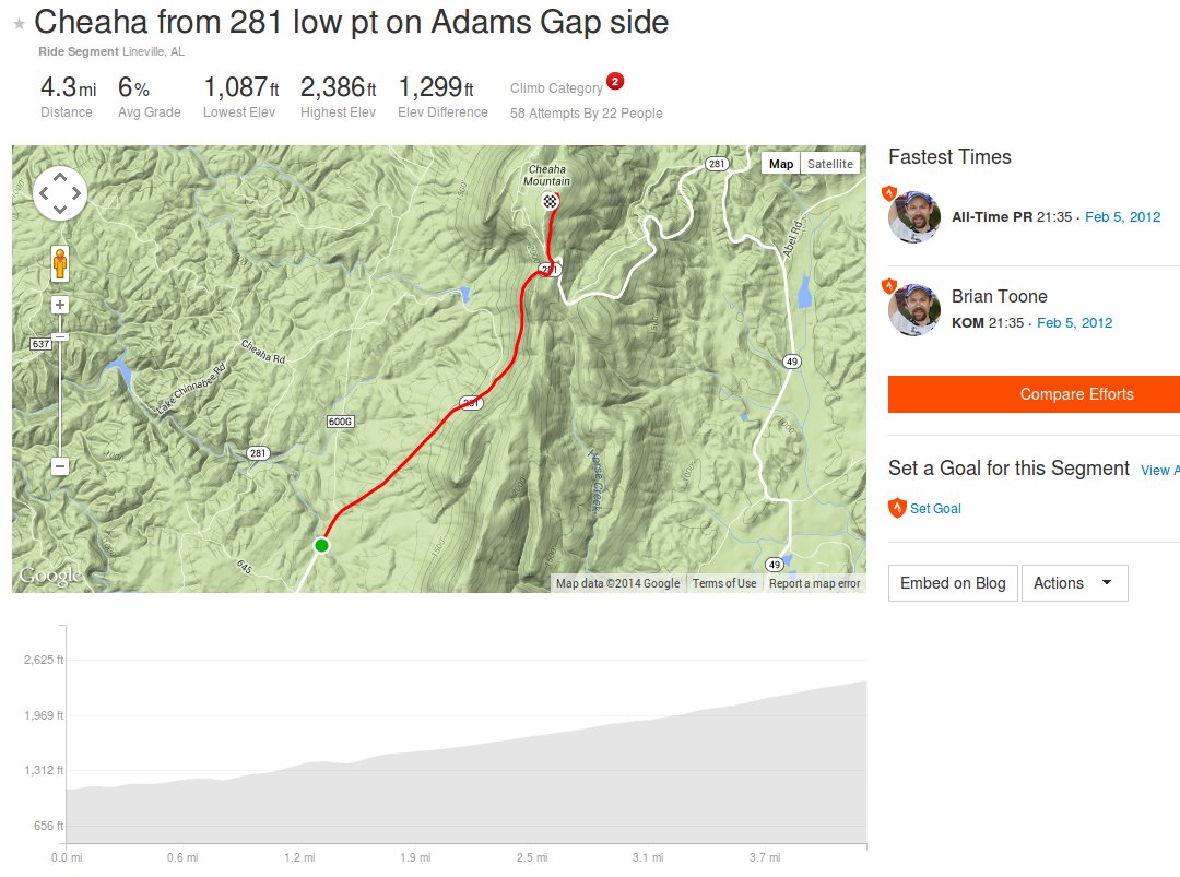
 Strava segment for my everesting of mount cheaha – “Cheaha from 281 low pt on Adams Gap side”
This segment is an interesting one that I made a few years ago – it’s the lowest spot on AL-281 on the west side of the mountain so it gives you the most vertical diff up to the lookout tower at the top (Alabama’s highest point at 2,407′). That low spot, however, is located in the middle of several steep rollers. So even though the vertical diff is about 1300′, you get even more climbing than that both on the way up and the way back down. I knew that this would make it easier to reach the everesting elevation, but I was surprised that it was over 2 full laps sooner than everesting based on the vertical diff alone. I wanted to everest it that way as well, so I did the required 23 laps.
This is probably the “best” climb in Alabama to everest. It may not be the fastest, steepest, etc… but it is the perfect grade for some fast climbing, yet not too steep to exhaust you quickly. Also, the descent is still plenty steep in spots to give you lots of free speed on the way back down. On top of that, the rollers at the bottom are fun and add to the climbing as I mentioned previously.
But perhaps what makes this climb the “best” is how scenic it is. During the day, the views are amazing as the climb rises quickly out of the valley with a good view looking far below. You really get the sense of climbing high in the mountains. Most everesting attempts end up involving some sort of night riding. The lower part of this climb is so open that moonlight really lights up the climb (and descent). I did several descents with no lights towards the bottom using just the moonlight … in addition to having a shadow from the moon, I could clearly see the outline of the road and the pavement was so perfectly smooth that there was no danger of hitting any debris. This was not the case higher up the mountain which goes through a heavily wooded section. After the storms a couple days ago, there was lots of branches and debris on the road. I found a good line though and cleared it out by riding it over and over again. By the end of the ride I was not worried about hitting anything at the top either. I used my light on its medium setting for this part of the descent, which twists gently (no brakes) several times, and is much darker because of the tree cover.
Well, I’m running out of time here, so I’ll leave with a collection of all the pictures I instagrammed. Previously, I had posted pictures at the 1000 meter elevation marks all the way up to the summit of everest. This time in honor of the work that Nuevas Esperanzas is doing in Nicaragua, I wanted to start out in Nicaragua, then Central America, and finally South America before running out of elevation and having to head over to Asia … but this time I picked K2 all the way up to its summit before finally switching over to Everest for the final summit picture.
These are the first few from Nicaragau:
To see the rest of the pics, click the collage below to go to my instagram account kartoone76

Leave a Reply