After three weeks of traveling out west and enjoying some really amazing riding and sightseeing with the family, I have been enjoying a week of riding back in Birmingham. Today’s ride typifies the type of ridge riding that you can do here in Birmingham. I started out this ride with a loop on the side of Little Valley Mountain followed by a route crossing all the major ridge lines to Birmingham. Then I turned around and took a different route home recrossing the same ridge lines at different points. After a quick stop at home, I did a loop through Bluff Park bouncing back and forth between the two ridge lines on top of Shades Mountain. That last bit through Bluff Park is shown with ridge and creek crossings highlighted in the first elevation profile and map below:
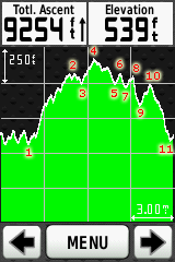
 Numbered crossings of the two ridge lines across the top of Shades Mountain. Click to enlarge


- My neighborhood – on the remnants of Altadena Ridge
- Little Shades Creek – feeds into the Cahaba River
- Little Valley Mountain – Panorama Dr home of S Cove, Renfroe, VHHS
- Little Shades Creek again – after the S Cove Dr descent
- Little Valley Mountain again – this time descending off the other side of the mountain via Gay Way
- Patton Creek headwaters – near Vestavia Pizitz Middle School
- Vestavia Lake overlook – high point on the lower Shades Mountain ridge
- Vestavia Falls bridge – tucked down below a cliff, cool and shady
- Hwy 31 at Shades Crest – right before the descent past Brookwood hospital. Crosses the upper Shades Mountain ridge
- Shades Creek – high bridge (Hwy 31) over the creek and Lakeshore trail
- Red Mountain on Woodcrest – http://goo.gl/maps/xHwf – super steep descent to Five Points South
- Five Points South – still nearly hundred feet above downtown (Village Creek, etc…)
- Red Mountain Crest Rd with all the mansions across the top of the ridge – http://goo.gl/maps/MTu2
- Shades Creek – after descending down through Mountain Brook (Crestline Village)
- Shades Mountain eastern ridge – the part of Shades Mountain east of US-280
- Shades Creek at the 280 flyunder – http://goo.gl/maps/hjbV – flying down westbound 280, cross under on Shades Creek Pkwy, back up the ramp/climb eastbound 280
- Shades Mountain high point crown – this includes the real high point at Vestavia Dr plus lower summits at Smyer Circle and Chester St
- Little Shades Creek – awesome descent down Vesclub – crossing the creek at an upper branch
- Dolly Ridge at Skyland roller coaster
- Little Shades Creek – down at the actual creek
- Dolly Ridge at Rosemary
- Altadena Ridge back in my neighborhood
Entire ride profile with 15 mile zoom (numbered ridges, creeks explained below)
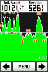
- Little Valley Mountain
- Shades Mountain
- Shades Creek
- Red Mountain
- Shades Creek
- Shades Mountain
- Shades Creek
- Shades Mountain
- Little Shades Creek
- Hoover
- Patton Creek
- Shades Mountain
- Patton Creek
And finally, here is a topocreator map of the entire ride … plus a super hi-res version (10.7MB).
 Entire ride – ridges and creeks annotated (click to enlarge) … or download the super hi-res version (10.7MB)
Leave a Reply