I might use “epic” a few times in this post… Today was epic x3, starting with my commute into work climbing up South Cove Dr inspired by the Dirty Dozen film I watched last night describing an annual ride that goes up Pittsburgh’s toughest climbs. Then after finishing teaching, I headed back home climbing up and over Little Valley Mountain hitting 60mph on the S Cove Dr descent. Afterwards, I hopped in the car to drive 43 miles out to Lake Howard in Sylacauga to pre-ride part of the Skyway Epic course. Traffic was already pretty bad on 280 and it took over an hour to get there and get ready to ride.
I headed out about 1:30 hoping that I had enough daylight to ride the course. 4 hours 15 minutes later, I just barely had enough light left finishing about 20 minutes after sunset. Along the way, I encountered just about every possible terrain you could imagine for a mountain bike race course – flowing singletrack, a few roots/rocks in singletrack, a grassy dam, various levels of bumpiness on gravel/dirt forest service roads and rural roads, steep rocky fire roads, huge mud puddles at the bottom of each hill across the top of the ridge line, fast steep relatively smooth descents, fast loose rocks … basically everything you could imagine in a non-technical epic mountain bike race.
COURSE ANALYSIS FOR THOSE INTERESTED IN RACING
THE SKYWAY EPIC ON MAY 20TH
- The singletrack portion that I rode is fast and smooth … only a few rocks and roots … much, much less than the Bump trail at Oak Mountain. I only had enough daylight to ride the opening singletrack section, but there is quite a bit more singletrack that will be included for the finish of the race … has anyone rode that portion and comment on whether it is more technical or about the same as the opening singletrack?
- The opening county roads (Wiregrass and Rocky Mt Church) are very fast in both directions. The rollers are pretty steep, but you can fly down the descents leading into the climbs to chop off some of the work you have to do on the climbs
- The “big climb” of the day is much more gradual than I expected. It does, however, go on and on forever. I rode the whole thing in my 38 (big chainring)
- There are some rather large mud puddles all across the top of the ridge line – basically every small hill that bottoms out into another small climb will have a large mud puddle. I was able to ride around most of them, but the ones I had to ride through were not that deep even though they were HUGE taking up the entire forest service road!
- The most difficult part of this entire course is the DESCENT and rollers from about mile 14 to mile 18 … I went FASTER on many sections of the climb back up (mile 36 to mile 40) than I did on the descent!!!
- The descent to the turnaround at AL-77 is very fast and fun. There are a couple of loose gravel corners mixed in with the fast corners. It is pretty easy to see the loose ones in enough time to brake.
- The entire skyway portion of the ride (mile 12 to mile 42) is rough with ruts, rocks, and sometimes water. I found a few sections where you can just bomb over the ruts, but there are definitely some sections where you need to pick and choose your line through the rocks/ruts carefully. If I were to guesstimate, I’d say that 25% of mile 12 to mile 42 is really rough, 50% is moderately rough, and maybe 25% is smooth. As I mentioned before, there are definitely some rough sections that you can still fly over, but there are also some rough sections that are kinda slow (at least for me, coming from a road racing background)
- Overall, the course is AWESOME. It is definitely EPIC. I am very tired after having ridden only the first third of the course at near race pace and not having ridden the last several miles of singletrack. This course has something for everyone, which should really even the playing field. Plus, simply finishing the race should be reward enough for anyone who enters!
Complete ride data from Strava is here: http://app.strava.com/rides/4244882.
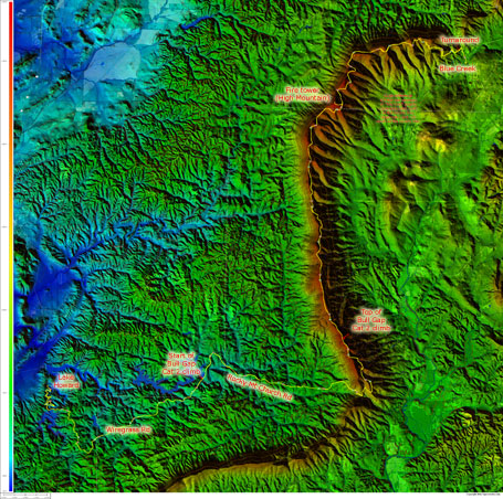
Here is the elevation profile and topocreator map – note that my garmin was reading a couple hundred feet lower than the real elevation. Note all the hills and the long climbs. The first long climb is Alabama’s newest Cat 2 – the climb from Rocky Mt Church Rd to the first high point on the Skyway forest service road. This brings Alabama’s Cat 2 climb total up to 9.
Finally, I’ll let the pictures and garmin screenshots tell the rest of the story for the day –
 Elevation profile – my Garmin recorded data is shown as the dark line shifted down (reading a couple hundred feet too low) – CLICK TO ENLARGE
 Annotated topocreator map of the ride – it should be fairly easy to see from the topography why this is called the “skyway epic”! CLICK TO ENLARGE
Leave a Reply