 Annotated panoramic view from Vestavia Hills Baptist church (click to zoom in and read the captions)
 Garmin elevation profile – 60 miles, Garmin elevation profile – 60 miles,10,000+ ft of climbing |
") Garmin – max speed 57.5mph Garmin – max speed 57.5mph(South Cove Dr) |
Out of the three 10,000ft rides so far this week (Red Mountain 1200s on Tuesday, South Shades Crest climbs on Wednesday), today was definitely my favorite by far. These are the roads I ride all the time, but usually not all in the same day! The entire route was nearly 65 miles long, yet the farthest point was only 5.2 miles (as the crow flies) from my house with Sulphur Springs/Shades Crest the western boundary and US-280 the eastern boundary of the route. I was toying with the idea of very carefully creating a diabolical route that could climb 10,000 ft in this area without any backtracking or route intersections, but that would have taken some of the fun out of just riding. Instead, I opted not to duplicate any climb. I did end up duplicating the middle part of the Vesclub climb and the final push to the top on Vestavia Dr – but otherwise, these are all different climbs of Shades Mountain in Hoover and Vestavia Hills. I documented them with screen captures at the steepest sections of the climbs – as well as lots of photos (126 photos narrowed down to 61).
First, the topography in this area is just absolutely incredible. And it’s not just because the area is especially rugged, because it really isn’t. Instead, what makes the topography so interesting is the combination of valleys, ridges, AND roads that go up, across, down, sideways, over, under everything! Note that for my route today, all the climbs are either on Little Valley Mountain or Shades Mountain on the SOUTHERN side in either the Patton Creek valley or the Little Shades Creek valley … so notably missing are some local favorites: Smyer, Berry, Big Bertha (W Oxmoor), and Hwy 31, which all start on the Shades Creek valley (different from Little Shades Creek). On the side I did ride, I somehow missed the Patton Chapel climb past Simmons.
 Hoover – Vestavia Hills topocreator map, annotated Click the map for a medium resolution version, or click here for a super hi-res version (10.2 MB)
Now, onto the climbs and the photos. I’m going to do a Garmin screenshot from a climb and then follow it up with one or more photos that were taken on that climb – but first…
 All ready to go … lots of water leftover from the heavy rain yesterday.
 - 1")
|
 - 2")
|
")
|
|
| South Cove neighborhood (but not south cove). The Garmin screenshots are taken near each other, with the second one just past the skid marks in the photo. | |
 The first climb up Shades Mountain was from the low point near Patton Creek on Al Sier Rd all the way to one of two high points on Shades Crest Rd – this one near Crest Lane. The pictures from the top are captioned here (you can also just hover over each pic for a caption) – 1) Shades Mountain Ballpark – I played baseball here from T-Ball to Junior High. 2) Looking towards the steep part of the climb on Shades Crest Rd. 3) Looking up at the steepest part of the climb – this is a busy road! 4) Took this pic to keep the camera from going into sleep mode while I was discreetly getting ready to take the next picture with the neighbors standing in the yard as I rode by. 5) Reminder that we do live in the South, even in Birmingham. Confederate flag. Alabama flag. Two other flags? Vote for Ron Paul. 6) The high point of the climb at the intersection of Crest Lane. |
     ")
|

|
 in the background")
|

|
|
| Shortly after the crest of the climb, you reach an interesting intersection which is a hub of activity. A long time ago, there was just Lover’s Leap and the antique store. Now there is also a very popular restaurant – Tip Top (aptly named). Hover over each picture for a caption. | |
 The next climb up the mountain started out next to the Green Valley golf course (at the Patton Creek bridge) climbing back up to Crest Lane – the same high point as the previous climb. Near the middle of the climb, I heard a hawk calling out overhead and then heard a response from a different hawk. I looked up and saw these two hawks flying together. It was really cool so I took a bunch of pics. But before I saw the hawks, I crossed several full creeks as I criss-crossed the mountain. Each creek creates a mini-roller coaster as annotated in the first picture. In the second picture, you can look ahead through two different creeks and see the hills that are created. After the hawks, I turned around to finish the climb up to Crest Lane and caught up with the van at the stop sign to take the picture of the slogan across the back. Plus, I took a picture of the narrow rough road at the end of the climb. |
      , the tornadoes every year, Hurricane Ivan, floods, etc...") 
|
| At the top of Crest Lane, I turned right again and took a few more pictures near the Tip Top Grill. There is one of the choo-choo train antique store called “On a Shoestring” antiques, and there is also an interesting historical sign talking about the origin of the area as a popular resort for some sort of springs at the top of the mountain. Then I took one of the small access roads off of Alford Avenue to get back up to Shades Crest Rd before descending down Hackberry (one of six 50+mph descents today). |
  
|
 After the descent down Hackberry. It was time to really hit the climbing – starting with Jacobs Rd – Mountainwoods. |
")   in the picture") 
|
") Instead of descending all the way back down into the valley, I headed back up over Columbiana Rd (after taking the last two pics from the previous photo set) and down into the valley that separates the two ridges at the summit of the mountain. Hurricane Branch is the name of the creek that runs through the middle where it joins some of the other creeks that form the headwaters of Patton Creek. The elevation gain from the creek to the summit is about 200-250ft on the southern ride and 250-350ft on the northern ridge. Today, I noticed a gate that was normally closed on an access road off of Blue Ridge Blvd was open – so I went down it and found a very muddy creek crossing. I started there and went up to one of the summits on the northern ridge on Shades Crest Rd – and lo and behold it was long and steep enough to be a Strava Cat 4 climb – so I actually discovered a new climb today in an area that I have literally ridden tens of thousands of miles. After that climb, I descended back down a different road to this valley between the ridges and climbed up the Old Creek/Indian Hill climb which is also a Strava Cat 4 climb – but one that I do all the time on my commute home from work. The Garmin screenshot is from the Old Creek climb — and the photos are from both climbs (the first two are associated with the new climb, and the next four go with the Old Creek climb). Instead of descending all the way back down into the valley, I headed back up over Columbiana Rd (after taking the last two pics from the previous photo set) and down into the valley that separates the two ridges at the summit of the mountain. Hurricane Branch is the name of the creek that runs through the middle where it joins some of the other creeks that form the headwaters of Patton Creek. The elevation gain from the creek to the summit is about 200-250ft on the southern ride and 250-350ft on the northern ridge. Today, I noticed a gate that was normally closed on an access road off of Blue Ridge Blvd was open – so I went down it and found a very muddy creek crossing. I started there and went up to one of the summits on the northern ridge on Shades Crest Rd – and lo and behold it was long and steep enough to be a Strava Cat 4 climb – so I actually discovered a new climb today in an area that I have literally ridden tens of thousands of miles. After that climb, I descended back down a different road to this valley between the ridges and climbed up the Old Creek/Indian Hill climb which is also a Strava Cat 4 climb – but one that I do all the time on my commute home from work. The Garmin screenshot is from the Old Creek climb — and the photos are from both climbs (the first two are associated with the new climb, and the next four go with the Old Creek climb).
|
     
|
After these climbs, I did the crazy Vestavia Forest speed reflector dodging descent followed by a diversion across Hwy 31 to Little Valley Mountain where I climbed up and over via 20+% Gay Way, turned around and then came back up 25% South Cove Dr. Below the Garmin screenshots, I have included an annotated photo of the descent showing the approximate max speed spot and where you have to brake to keep from crashing. Also, I have a picture taken at the top which shows the blind curve where you have maybe 1/10th of a second to decide whether it’s a “go” or “no go” on the descent. Sometimes you just have a bad feeling and hit the brakes. Sometimes you see a car pulling out of a driveway or at the cross street and hit the brakes. Or sometimes you see cars parked alongside the road and you hit the brakes. But if it is completely clear, then you tuck and accelerate from about 40mph up to 60mph in only two or three seconds. It would be interesting to calculate what percentage of free-fall skydiving acceleration this descent is … my rough guess would be 25-50% … i.e, you are accelerating at a rate equivalent to 25-50% of simply jumping off a cliff. In other words, this is a really, really dangerous descent. CLICK EACH PICTURE TO ZOOM IN.
")
|

|


 Panorama of the Vesclub roller coaster descent. While we are talking about descents – here is a panoramic photo showing a descent that causes an interesting Garmin phenomenon. This is the middle part of the Vesclub climb – but if you come back down at close to 50mph and then make the hard right turn up the 18-20% gradient where I was standing when I took the pictures that make the panorama, then you can achieve a 3 second vertical acceleration of greater than 10,000 ft/hour upwards simultaneously with a 30 second vertical acceleration of greater than 10,000 ft/hour downwards.

|

|

|
| Before I could descend down Vesclub – I first had to get over to it and climb it. From South Cove Dr, I headed across Panorama and down Limerock Rd past Vestavia High School into Rocky Ridge to do the longest/steepest climb of the day — Vestavia Dr from Little Shades Creek. This climb has well over 800 ft total gain and several sections with gradients approaching 20% and one section with gradient above 20%. I got Garmin screenshots of the first three sections of the climb, but missed the steepest one by the golf course. These are the pictures I took on the way up, across the top, and then on the way back down. |
   
|
After the descent, I headed across to Dolly Ridge, climbed back up to Smyer Circle and Vestavia Dr via Caldwell Mill Rd (the portion of it that is north of I-459). On Caldwell Mill, I heard another hawk very loudly crying and I looked up and spotted him in the tree above me. When I made it up to Smyer Circle, I stopped at the Vestavia Hills Baptist Church overlook and got the Panorama shown at the very beginning of this extremely long post. Then I descended down stopping along the way at Vestavia Falls. So I’ll end this post with a thank you if you read all the way to here and these two pics (of the hawk and the waterfall)
 Beautiful red-tailed hawk
 Vestavia Falls
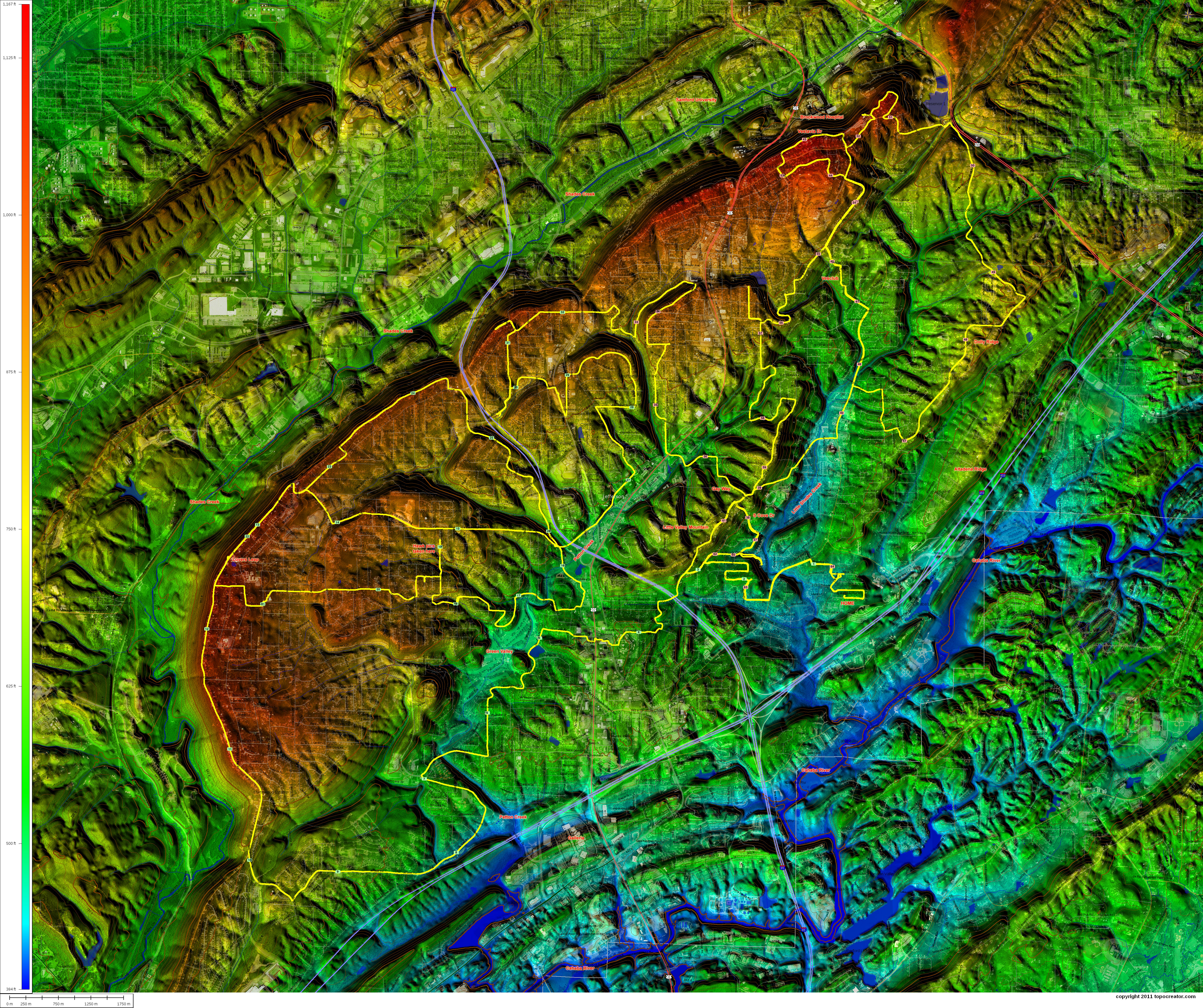
Leave a Reply