In between my morning and class and my senior presentations this afternoon at the student research showcase, I was able to bike over to Cahaba Heights and Dolly Ridge and get closer to where the tornado went through. I was only able to snap a few pics, though. Again, these pictures represent the damage from a very small, narrow tornado probably an EF0 or EF1. Imagine the damage from a much, much larger tornado with wind speeds in the EF4, EF5 range and that is what Tuscaloosa and Pleasant Grove look like.
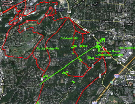
Here is an updated map of where I think the tornado went based on going back out there again today:
 4/28 updated damage path satellite view. The green X’s are large trees pushed over or broken in half. Many more than what is shown. These are just the ones that stood out to me. The red lines are where I rode my bike on my commute yesterday.
Leave a Reply