Today was awesome. I’m going to try to convey some of the ride highlights, but I think this post is going to be kinda long. First, as I was climbing up on top of Double Oak Mountain, a red-tailed hawk swooped down from a tree beside me and flew in front of me for a few seconds. I was in maybe the “poop zone” only 10-15 meters behind him and maybe 10-15 meters below him. So if he pooped, I think it would have fallen on me. Anyway, it was cool to admire the hawk gliding away from me and then pulling up to land on a tree when the road bent slightly, and the hawk kept on going straight. It brought back memories of three other close encounters with red-tailed hawks all here in Birmingham.
1. Descending off of Vestavia Dr at about 30mph towards Vestavia Baptist Church, a hawk was flying beside me at about the same speed. The hawk spread his wings wide as he pulled up to land on a tree. The sun was behind me shining on the hawk so you could see the rust red tail very clearly.
2. Descending down Hackberry Rd at close to 50mph, a hawk divebombed across the road immediately in front of me to catch something beside the road. I missed hitting it by only a few feet (tenths of a second when traveling at 50mph)
3. Starting the climb up Rocky Ridge Road just past Countrywood, a hawk divebombed to the grass just beside the road to catch a chipmunk. It’s no wonder that you see hawks get run over by cars every now and then. They must get so “in the zone” when they are trying to catch something that they don’t watch what’s happening around them!
What is your favorite hawk story? Surely I’m not the only one who has seen them on rides here in Birmingham! Has anyone hit one before while biking?
And now onto the ride stats and climbing stats thanks to my awesome iBike power meter –
---------Total Ride---------
Dist:      104.06 mi (5:56:09)
Energy:    4293.5 kJ
Cals Burn: 4104.7 kcal
Climbing:   12795 ft
Braking:   -486.5 kJ (-11.3%)
          Min   Avg    Max
Power       0  200.9   726  W
Aero        0  109.7  1822  W
Rolling     0   23.3    73  W
Gravity -3662    4.8   904  W
Speed     0.0   17.5  55.9  mi/h
Wind      4.9   15.3  43.4  mi/h
Elev      126    513  1241  ft
Slope   -23.6   0.08  23.3  %
Caden       0   77.3   128  rpm
HR         85  140.7   176  bpm
NP 246 W; IF 0.886; TSS 465.8
1/30/2011 8:01 AM
62 degF; 1012 mbar
So the ride wasn’t awesome just because of its length and climbing, but rather just a number of things that came together on the ride. First, despite another long week of training and a hard BBL ride yesterday, my legs felt fresh without the burning pain that was plaguing me at the end of last week. I was totally surprised by this seeing as how I was finishing off the second 400+ mile week in a row! So feeling good was in itself a motivator to push the ride to the extreme.
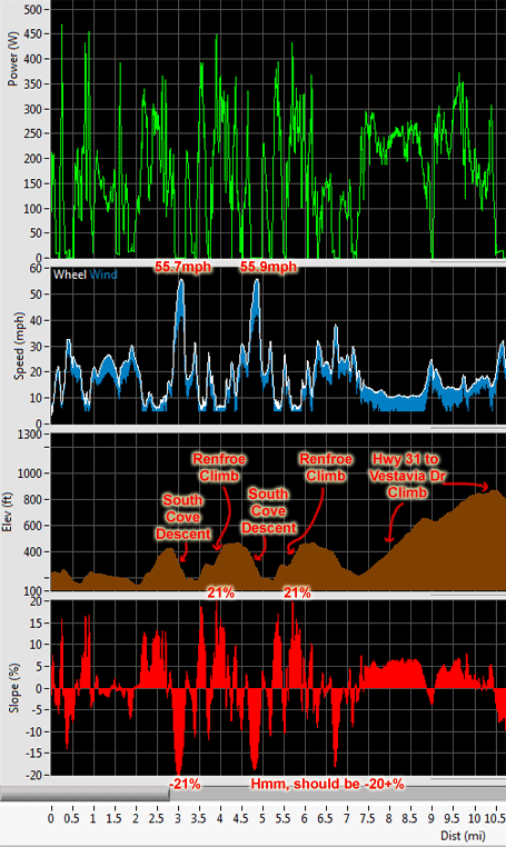
And the ride got off to the “extreme” right away, hitting a new max speed of 55.7mph down South Cove (verified by both my Garmin and my iBike) on the first of two descents. Then after climbing back up via Renfroe, I hit 55.9mph the second time down. This felt even faster than the first time (i.e., more than 0.2mph faster), because I waited a bit too long to brake and had to take the 90 degree turn at the bottom at nearly 25mph, which is a typical crit speed for a 90 degree corner – but feels entirely different when decelerating rapidly from nearly 56mph. By the way, if you live in Birmingham and want to try this descent, please, please, please DO NOT try to go this fast on it. I know every bump, every corner, when to brake, where to look for cars, where the “go”-“no go” point is, where the escape routes are, and still it is extremely dangerous. Plus, I would never do this descent at this kind of speed other than on a Sunday morning early, where the only danger would typically be a walker or jogger. But there aren’t too many people who are willing to walk/jog a 20+% hill, so I’ve never seen anyone walking or jogging on it.
 South cove 55mph descents plus Hwy 31 climb to Vestavia Dr
I split the ride up into two rides (56.9 miles to church and then 47.1 miles back home) with about an hour break listening to our pastor preach about James. There is something about hearing the Word of God in the middle of a ride that makes it sink a bit deeper. Kristine and I had a good talk about the sermon later in the day. Speaking of Kristine, she was another highlight of the ride! So besides being at church with her, I ran into her again towards the end of my ride when she was out for a long run. She had left the kids off with my parents and was about halfway through her run, when I missed a light in Rocky Ridge and decided to turn right at the light onto Morgan Dr rather than waiting at the light, and climb up past Vestavia High School for some extra climbing. Well, as I crossed the creek, there was Kristine running on the sidewalk by the road. So I went ahead and did the climb, came back down, and rode with her for a few minutes through one of the small neighborhoods. She decided to run up to Panorama past the high school, and I decided I would climb up via Renfroe and double back to meet her at the top. It worked perfectly, and I got to ride alongside her for another couple minutes as she crested the climb. Out of food, out of water, I headed home while she finished up her run.
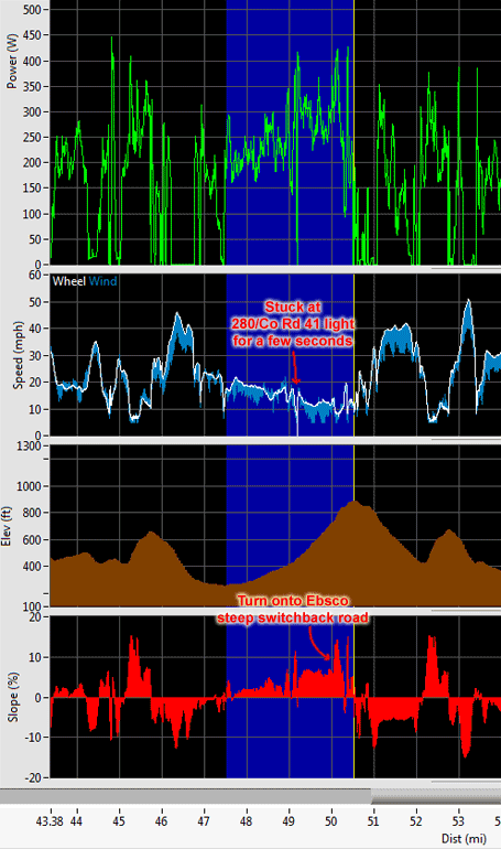
For those of you interested in knowing more about the climbs from the ride, I’ve included below all the stats for each climb that I labeled in the iBike data. But before I put those, let me show a zoomed in view of one of my new favorite climbs – the Ebsco parking lot climb. Check it out!
 The Ebsco parking lot climb
This is another “Sunday only” climb as at least half of it is on Hwy 280. You start out the climb on Old Hwy 280 which is an amazing little road in a deep ravine that follows a creek as it climbs gradually. The climb through here is very gradual so you can admire the cliffs on either side. Then once you make it up towards the traffic light at the intersection of Co Rd 41 and Hwy 280, the road gets steep. Turn left onto 280 to complete the steadiest part of the climb at about 6-8% gradient. Fortunately, in the latest repaving of 280, there is about a 1 foot wide strip to the right of the white line but still left of the rumble strip that used to go all the way to the white line. So now you can ride off the highway, but on the left side of the rumble strip relatively debris free. As you get close to the top, start looking back for an opening to switch over to the left side of the road where a lefthand turn lane starts up for about a quarter mile leading up to the left turn onto the STEEP Ebsco switchback road. Climb up to the main building, veer right, and then just keep climbing all the way to the very top of the parking lot. At exactly 3.0 miles and 631 vertical feet, this climb is the longest continuous climb with no downhills in Birmingham (as far as I know!)
Ok, here they are – all the climbs – plus their Strava category rating:
---------Hwy 31 to Vestavia Dr High Pt---------
---------STRAVA CAT 3 -------------------------
Dist:        3.19 mi (0:14:05)
Energy:     192.5 kJ
Cals Burn:  184.0 kcal
Climbing:     689 ft
Braking:     -3.3 kJ (-1.7%)
          Min   Avg    Max
Power       0  227.8   372  W
Aero        0   24.4   177  W
Rolling    13   18.1    33  W
Gravity  -322  176.8   371  W
Speed    10.1   13.6  24.6  mi/h
Wind      5.0    8.4  19.9  mi/h
Elev      516   872   1171  ft
Slope    -3.9   3.78   7.9  %
Caden      13   78.1   101  rpm
HR        125  150.7   169  bpm
NP 241 W; IF 0.870; TSS 17.8
1/30/2011 8:30 AM
51 degF; 1012 mbar

---------Caldwell Mill to Smyer Circle High Pt---------
---------STRAVA CAT 3 -------------------------
Dist:        1.90 mi (0:10:25)
Energy:     159.6 kJ
Cals Burn:  152.5 kcal
Climbing:     599 ft
Braking:     -6.9 kJ (-4.3%)
          Min   Avg    Max
Power       0  255.3   466  W
Aero        0   20.5   241  W
Rolling     8   14.6    34  W
Gravity  -610  198.6   455  W
Speed     6.4   11.0  25.8  mi/h
Wind      5.0    8.5  22.7  mi/h
Elev      586   863   1136  ft
Slope    -8.9   5.27  15.3  %
Caden       4   75.7   106  rpm
HR        103  145.9   164  bpm
NP 285 W; IF 1.027; TSS 18.3
1/30/2011 9:05 AM
53 degF; 1012 mbar

---------Hugh Daniel to Brae Trail High Pt---------
---------STRAVA CAT 3 -------------------------
Dist:        2.17 mi (0:10:53)
Energy:     167.6 kJ
Cals Burn:  160.2 kcal
Climbing:     594 ft
Braking:     -8.0 kJ (-4.8%)
          Min   Avg    Max
Power       0  256.6   451  W
Aero        0   32.6   220  W
Rolling     8   15.9    32  W
Gravity -1164  191.0   437  W
Speed     5.8   12.0  24.1  mi/h
Wind      5.0   10.5  22.9  mi/h
Elev      601   882   1179  ft
Slope   -14.9   4.66  18.7  %
Caden       9   74.6    99  rpm
HR        136  150.2   165  bpm
NP 282 W; IF 1.017; TSS 18.8
1/30/2011 9:48 AM
64 degF; 1012 mbar

---------Mt Laurel to Double Oak Radio Towers---------
---------STRAVA CAT 3 -------------------------
Dist:        3.76 mi (0:17:39)
Energy:     250.1 kJ
Cals Burn:  239.1 kcal
Climbing:     827 ft
Braking:    -18.3 kJ (-7.3%)
          Min   Avg    Max
Power       0  236.2   492  W
Aero        0   52.8  1038  W
Rolling     0   17.0    61  W
Gravity -2354  139.8   476  W
Speed     0.0   12.8  46.1  mi/h
Wind      5.1   11.3  35.6  mi/h
Elev      797   1162  1485  ft
Slope   -15.8   3.20  23.3  %
Caden       0   73.2   112  rpm
HR        119  142.9   164  bpm
NP 269 W; IF 0.970; TSS 27.7
1/30/2011 10:08 AM
62 degF; 1012 mbar

---------280 Ebsco Parking Lot High Pt---------
---------STRAVA CAT 3 -------------------------
Dist:        3.00 mi (0:12:55)
Energy:     199.1 kJ
Cals Burn:  190.4 kcal
Climbing:     631 ft
Braking:     -0.7 kJ (-0.4%)
          Min   Avg    Max
Power       0  257.0   426  W
Aero        0   47.5   161  W
Rolling     0   18.5    29  W
Gravity  -227  182.2   426  W
Speed     0.0   13.9  21.7  mi/h
Wind      5.0   12.3  22.0  mi/h
Elev      551   814   1184  ft
Slope    -3.8   3.81  15.0  %
Caden       0   76.7    95  rpm
HR         98  148.7   170  bpm
NP 271 W; IF 0.976; TSS 20.5
1/30/2011 10:50 AM
65 degF; 1012 mbar

---------Chelsea Railroad Bridge to Double Oak Radio Towers---------
---------STRAVA CAT 3 -------------------------
Dist:        8.68 mi (0:31:46)
Energy:     462.4 kJ
Cals Burn:  442.0 kcal
Climbing:    1222 ft
Braking:    -16.6 kJ (-3.6%)
          Min   Avg    Max
Power       0  242.6   526  W
Aero        0   86.0  1104  W
Rolling     0   21.8    61  W
Gravity -2281  113.5   502  W
Speed     0.0   16.4  46.4  mi/h
Wind      5.1   14.5  37.0  mi/h
Elev      483    915  1481  ft
Slope   -15.7   2.02  21.8  %
Caden       0   78.3   122  rpm
HR        116  150.3   170  bpm
NP 268 W; IF 0.967; TSS 49.6
1/30/2011 11:33 AM
67 degF; 1012 mbar

---------Mt Laurel to Greystone Crest---------
---------STRAVA CAT 4 -------------------------
Dist:        2.66 mi (0:10:08)
Energy:     144.0 kJ
Cals Burn:  137.7 kcal
Climbing:     404 ft
Braking:     -0.3 kJ (-0.2%)
          Min   Avg    Max
Power       0  236.9   599  W
Aero        0   74.2   230  W
Rolling     8   21.0    32  W
Gravity  -330  136.3   554  W
Speed     6.5   15.8  24.4  mi/h
Wind      5.1   14.4  23.4  mi/h
Elev      797    913  1166  ft
Slope    -6.7   2.52  22.8  %
Caden      12   78.3   104  rpm
HR        129  146.3   171  bpm
NP 287 W; IF 1.035; TSS 18.1
1/30/2011 12:14 PM
64 degF; 1012 mbar

---------Caldwell Mill (Cahaba River) to Vestavia Dr High Pt---------
---------STRAVA CAT 3 -------------------------
Dist:        5.97 mi (0:23:49)
Energy:     351.5 kJ
Cals Burn:  336.0 kcal
Climbing:    1042 ft
Braking:    -26.1 kJ (-7.4%)
          Min   Avg    Max
Power       0  246.0   649  W
Aero        0   77.6   825  W
Rolling     6   20.0    52  W
Gravity -1443  116.4   533  W
Speed     4.9   15.1  39.0  mi/h
Wind      5.0   13.6  34.5  mi/h
Elev      460    762  1185  ft
Slope   -12.1   2.26  15.1  %
Caden      17   76.0   104  rpm
HR        106  146.0   176  bpm
NP 278 W; IF 1.001; TSS 39.7
1/30/2011 12:56 PM
65 degF; 1012 mbar

---------Little Shades Creek to Panorama via Renfroe---------
---------STRAVA CAT 4 -------------------------
Dist:        1.36 mi (0:06:54)
Energy:     101.2 kJ
Cals Burn:   96.8 kcal
Climbing:     338 ft
Braking:      0.0 kJ (0.0%)
          Min   Avg    Max
Power       5  244.5   459  W
Aero        0   49.8   297  W
Rolling     7   15.7    35  W
Gravity  -728  174.3   439  W
Speed     5.3   11.8  26.1  mi/h
Wind      5.0   11.3  25.2  mi/h
Elev      219    359   542  ft
Slope    -8.9   4.31  17.5  %
Caden      25   69.2    91  rpm
HR        123  143.6   154  bpm
NP 271 W; IF 0.976; TSS 11.0
1/30/2011 1:40 PM
64 degF; 1012 mbar
Ok, really, this is the last thing – it was a beautiful day and here are a couple cellphone pics I took during the ride:
 The Double Oak Mountain doppler radar tower

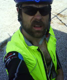
Not the best self-portrait on top of Double Oak Mountain, but I was tired and staring at the bright light from the sun just below the edge of the building that was shading me. Also, note that it had gone from 40 degrees when I left my house to over 70 degrees in the sun when I took this picture!
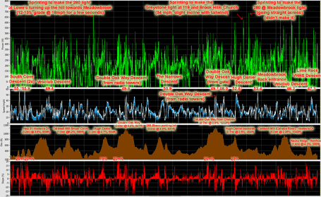
 iBike ride data annotated with climbs, descents, max speeds, max slopes, and power spikes. Click for larger version.
Leave a Reply