This blog tells the story of riding the rest of the way across Nebraska into states I hadn’t even been planning on being anywhere near when I set out from Canada over 2000 miles before this section even starts!
TLDR Summary
From nearly flooding my hotel bathroom in Ogallala, Nebraska through the bike friendly rails to trails across Iowa and then following and crossing the Mississippi River (many times) down through Illinois and Missouri, including a nice detour through Mark Twain’s hometown — this section was awesome!
The news kept reporting about a heat dome covering most of the central part of the country, and this manifested itself in not only heat, but also a strong wind blowing up from the south. I continued heading east and even northeast following US Hwy 30, battling the cross-wind and rejoicing when my route would turn making it a cross-tailwind sometimes … always with the slight dread as I crept farther and farther North that I would have to make up all those miles into a headwind eventually to make it back to Alabama. I was surprised to find myself within a day’s ride of Chicago and only a couple days away from family in the Twin Cities!
Through the heat dome, I got walloped by a few extended thunderstorms in Iowa, which helped with the heat, but that is just trading one misery for another. The wind did start to slacken a bit when I turned south after crossing the Mississippi River into Illinois, but my entire ride along the Mississippi River was into an annoying 5-7mph headwind for hundreds of miles. Thankfully the scenery was phenomenal and I found myself giddy with excitement while fighting off a number of miserable long distance cycling issues at the same time.
As an example of the juxtaposition of misery and beauty, I was riding along the east side of the Mississippi River on a road that was kinda rough and hilly and still into that hot headwind even getting towards the end of the day when I ran out of water. I checked Google Maps, and the nearest gas station was almost 10 miles away with another 15 miles after that to get to Quincy where I was spending the night. But the view of the river beside me, and the light of the sun already starting to get lower on the horizon on the trees along the river and the steep bluffs was phenomenal. It was hard to despair in such beauty so I just kept plodding along slowly into the wind on a bumpy chip/seal road, miserable with saddle sores from storms that had soaked me earlier in the day. An hour or so after the gas station, traffic got busy as I finally made my way into Quincy and to the hotel with an amazing view of the Mississippi River. After getting checked in and taking a quick shower, it was 8:55pm. There was only one restaurant still open within a few blocks of my hotel, but after walking in at 9:01pm, the waitress said, “Sorry, we just closed”. Of course.
Still, it wouldn’t be an adventure if everything was just easy and perfect. The challenge of it isn’t just the miles, it’s also all the logistics, unexpected, and the unknown. I wouldn’t have it any other way.
Daily TLDR and Links


Day 12 – Ogallala, Nebraska to Kearney, Nebraska
150.1 miles, 886 ft climbing, 10h 15 min
Almost flooded the hotel room the night before, but left before midnight to beat the heat. Continued all the way across Nebraska on US 30.
Day 13 – Kearney, NE to Missouri Valley, Iowa
190.4 miles, 2385 ft climbing, 13 hr 2 min
Finished 450 miles on US Hwy 30 all the way across Nebraska and across the Missouri River to Iowa.
WATERFALL HUNTING FROM ROAD PROHIBITED!
Day 14 – Missouri Valley, Iowa to Urbandale, Iowa
160.1 miles, 5,761 ft climbing, 12hr 7min
Ran out of water in the middle of the night and ended up on many unexpected miles of rails to trail all the way to Des Moines.
Day 15 – Urbandale, Iowa to Coralville, Iowa
161.0mi, 5,928 ft climbing, 11hr 50min
Lots of morning storms and an unexplained flat tire quickly inspected and fixed by Geoff’s Bike Shop near the University of Iowa.
Day 16 – Coralville, Iowa to Quincy, Illinois
182.2 mi, 5,203 ft climbing, 13hr 32min
Waited out some heavy thunderstorms only 6.5 miles after leaving the hotel early morning. Finished riding across Iowa and made it to the mighty Mississippi River crossing at Burlington, Iowa. I finally made my turn south towards home riding in the flood plain and hilly bluffs ultimately making it to Quincy Illinois right at sunset. Ran out of water late afternoon in the midst of beautiful rural scenery.
Day 17 – Quincy, Illinois to St Charles, Missouri
128.8 mi, 5,456 ft climbing, 10hr 24min
It was the best of times, it was the worst of time. Started out crossing the Mississippi River again but this time into Missouri. Great time exploring the hometown of Samuel Clements (Mark Twain). Got hot yet again and had several lockup cramps during and after the ride after negotiating heavy, heavy Missouri traffic.
Days 18 and 19 – St Charles, Missouri to Kennett, Missouri via Farmington Hills
100.0.mi, 5,587 ft climbing, 8hr 17 min (1st ride)
170.9mi, 4,865 ft climbing, 12hr 38min (2nd ride)
Sunrise on the arch in St Louis leaving the busy traffic behind for dirt roads climbing up the hills before returning down to the MO boot plains.
Day 12: Chased by trains night and day while hiding from the heat in the shade of grain elevators
Ogallala, Nebraska to Kearney, Nebraska
Saturday, 6/21 @ 12:31AM MDT
150.1 miles, 886 ft climbing, 10h 15 min
https://www.strava.com/activities/14873162142
499 vehicles, 3.2/mi, 0.81/min 55.3 mph (avg), 89.6 mph (max)
https://www.mybiketraffic.com/rides/view/412664
Let’s start with me nearly flooding my hotel room at the end of the day before. After walking to McDonalds next door and having a nice sit-down meal, I headed back to the hotel to take a shower. There were two different kinds of knobs on the bath/shower combo with both of them looking like cheap replacements to whatever the original knobs were.
I got the water in the shower going and as typical for a cheap hotel, the drain in the tub couldn’t keep up with the water so it was pooling at my feet as I took a quick shower. But when I attempted to turn the water off, only the hot water turned off. I couldn’t get the cold water to turn off. The knob would just spin and spin while the tub continued to fill (even with the drain open). Don’t panic. I could see a phillips head screw holding the knob in place, so I got the multi-tool off my bike and was able to get the knob off, thinking I could just turn the valve manually. But without the knob there was no way for me to get enough leverage to turn the valve!
By this point, the water was nearing the top of the tub. I was panicked by this point, but used my multi-tool to put the knob back on as a last ditch effort to turn the water off. And amazingly, this time when I turned the knob, it grabbed the valve and shut the water off — less than an inch from overtopping. Whew.
With temps reaching 118 degF during the day, I knew that I wanted to ride as much as possible at night so after dealing with the water, I fell quickly asleep with my alarm set for 11:30pm and was out the door by 12:30am. I ran into the worker who had checked me in as I was leaving, so I told him about the near disaster and that he really needed to fix that before somebody floods the room!
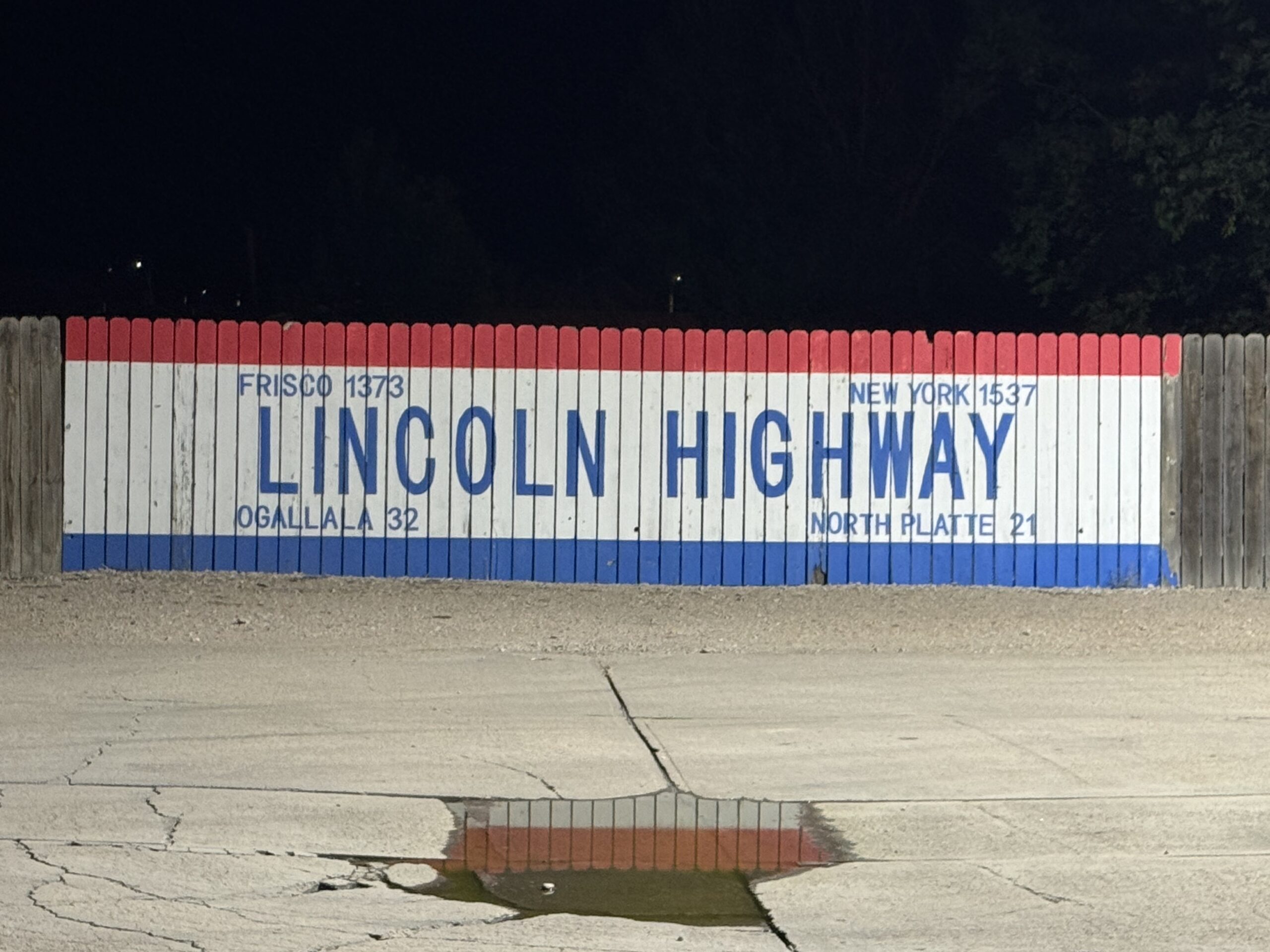
I made my way out of Ogallala on a very flat US Highway 30 (the Lincoln Highway) with almost zero traffic and used the towns that dot the highway every 10-15 miles to help pass the time. Each town would have a huge grain elevator complex and usually a pedestrian bridge across the railroad tracks, which were very busy. I was frequently getting caught and passed by trains. After such high temps the previous day, it was nice to ride in the “cool” of the night (i.e., upper 70s), and the challenge is still finding an open gas station before running out of water, especially since I was hundreds of miles north of my original route where I had spent a lot of time ahead of time mapping out the exact location of 24 hour gas stations.
My plan had been to make it to Kearney by lunch ahead of the heat for a shorter day of riding so I could get started again early to maximize riding at night, but I didn’t get there until 1pm (including losing an hour by crossing over into the Central Timezone) and having to ride in a couple hours of 100+ degF heat with my Garmin reading 108 degF as I made it to the hotel. I titled the ride on Strava “tried to beat the heat, but the heat won”. I got to ride a few bike paths at the very end to avoid the traffic that had picked up, which made the last hour or so getting closer to Kearney kinda stressful as packs of fast moving trucks and cars approaching from either direction. Thankfully there was a wide shoulder on the far side of the rumble strip, but it was pretty nasty with some sort of gravel in places so I would wait until the radar told me cars were approaching and then cross over the rumble strip and until cars passed me both ways before returning to the smoother shoulder on the left of the rumble strip.
After checking into the hotel and showering, I was able to have some real food at a sit-down burger place that was across the parking lot from the hotel. I started a load of laundry before leaving for the restaurant, moved it over to the dryer when I got back, and was promptly asleep as soon as the dryer was done. Still, I had a good solid 6+ hours of sleep before leaving again the same day at 10:51PM.
Day 13: An unexpected finish across Nebraska
Kearney, Nebraska to Missouri Valley, Iowa
Still Saturday, 6/21 @ 10:51PM CDT
190.4 miles, 2385 ft climbing, 13 hr 2 min
https://www.strava.com/activities/14884169298
688 vehicles, 3.6/mi, 0.88/min, 51.5 mph (avg) / 81.1 mph (max)
https://www.mybiketraffic.com/rides/view/403037
During this trip, I would book my hotels using Google Maps usually about halfway through the ride once I was fairly confident about the farthest place I could make it that day. There were two cheap Super 8 hotels and I thought I had booked the one on the Nebraska side of the Missouri River, but when I went to check in, the clerk couldn’t find the reservation. Sure enough, I checked my reservation again, and I had booked the one about 10 miles farther across the river in Missouri Valley, Iowa.
This ended up being a long day even with checking into the hotel shortly after noon. It started the night before leaving Kearney at 11pm with the temperature still in the upper 80s degF! Throughout the night the temp eventually dropped to about 80 degF which has got to be close to record high “low” temps for the area. The nighttime scenery was more of the same – train tracks to the side, distance town lights behind and in front of me along US Highway 30. After a couple hours of riding, I came to a town with yet another pedestrian bridge across the tracks to the elevator grain complex, and I figured it would be a fun diversion/change of pace to ride up and over the tracks. It was.
It stayed hot throughout the night, and got even hotter from early in the morning, so much so that I was stopping frequently to find shade to take a break from the sun long before lunchtime. Traffic got busy as I made it to the city on the Missouri side of the river where I thought my hotel was and stayed busy as I left town on the only highway crossing the river for many miles. Hilariously, when I finally crossed the Missouri River into Iowa, I saw large signs every mile or two still along US Highway 30 saying in huge font: “WATER FOWL HUNTING PROHIBITED FROM HIGHWAY”.

Despite the traffic and the heat, I’m glad I had mistakenly booked the Iowa hotel because that meant I could see the last few Nebraska miles of US Highway 30 in the daylight, including this 450 mile signpost shortly before the border, which is significant because I rode every single one of those 450 miles crossing the entire state of Nebraska on this one highway. Possibly even more significant than that, I had never even ridden a single mile in Nebraska prior to this trip and now I had ridden all the way across it in just two and a half days.

Day 14: Bike friendly Iowa
Missouri Valley, Iowa to Urbandale, Iowa
Monday, June 23rd, 2025 @ 12:07am
160.1 miles, 5,761 ft climbing, 12hr 7min
https://www.strava.com/activities/14893268244
169 vehicles, 1.3/mi, 0.3/min, 40.3mph(avg) 65.3mph(max)
https://www.mybiketraffic.com/rides/view/403748
I had intended to take US Highway 30 all the way across Iowa, but the nighttime availability of gas stations through the first rural section proved problematic. In the hotel room before falling asleep, I had tried to map potential 24 hour gas stations, and I had seen one at 30 miles and another at 50 miles into the route. This normally would be no problem, but the temps were again in the 80s overnight, and I had left my hotel thirsty (big mistake) and basically drank an entire bottle before even making it a couple miles down the road leaving me with only one bottle to make it the rest of the way to Dunlap to the “24 hour gas”. As I was leaving this cool little town called Woodbine and noticed how little water was left in my second bottle, I got paranoid about the “24 hour gas” and looked up the reviews and saw a review that said “You can get gas 24, but the store closes.”
Uh-oh. No way I was going to make it another 30+ miles on less than a bottle. Woodbine didn’t look like it had anything open, but I turned around anyway and figured I could ride through the few streets of the town and find an outside vending machine somewhere. I had plenty of dollar bills specifically for this purpose. But unfortunately, there was nothing. I did a quick Google Maps search for gas and the closest currently open gas station at 1:30 in the morning was 20 miles behind me across the street from the hotel where I had started! The next closest was about 20 miles away in a town called Harlan due East whereas US Highway 30 continued on significantly farther North before turning East.
So at this point, I decided to say goodbye to US Highway 30 and took 144th Street east out of town from Woodbine. I had no idea what to expect, but it immediately got extremely hilly … steep climbs ranging from just a short hill to 1/2 mile long and then a descent of about the same length with the road continuing east pretty much straight as an arrow across constant hills. I eventually made it to the Casey’s 24 hour gas station in Harlan long before sunrise, which was good because at this point I joined Iowa state highway 44, which got busy quick and was heading directly into the rising sun. Thankfully the road turned just enough that the never-ending sunrise stayed off to the left of the road a bit. It was a gorgeous sunrise and with some low hanging clouds with sporadic holes, the sunrise colors seriously lasted for maybe another hour after sunrise.


It was mid-morning by the time I made it to Guthrie Center after endless hills and farms. A huge farm tractor was chasing me down into the outskirts of town but I was just able to stay ahead of it to the gas station. I think this helped ease some of the traffic congestion as they were hesitant to go around this huge tractor.

After a good gas station stop, I was glad to get on my way again but traffic was pretty bad. Lots of fast cars approaching with lots of hills. I was looking for a way to get off this highway when I saw what looked like an extremely popular bike trail (based on the darkness of the map line on my Garmin Edge popularity map). I hopped onto it and headed way out of my way due north for many miles, but I was thankful to be out of the traffic and in no particular hurry to make it directly to the suburb of Des Moines where I had already booked a hotel. In fact, I knew I would need to add on miles to have halfway descent mileage on the day. Not only was I trying to make it home in a reasonable amount of time, I was also trying to ride a good solid 4000 miles! I ended up making it all the way home on time, but I was about 250 miles short of the 4000 mile goal … even with things like the extra 15 miles I added on wandering around the Des Moines suburbs on this ride.
But before getting there, I had many miles of rails to trail to ride. Some of the newly paved sections were great, but some of the older sections had the ice cracks that plague the upper midwest. These cracks are super annoying to ride … even on a gravel bike with 42mm tires. Smooth, bump, smooth, bump, smooth bump, with each bump quite jarring. Still, it was a relief to have car free miles for many miles. And just when I thought I couldn’t take it any more, there would be a trail intersection and new pavement on the other side.


By the time I made it into the outskirts of Des Moines, traffic was terrible on the roads, but the rails-to-trail continued alongside the main highway. I ran into two bikepackers who were returning from a trip across the state. I chatted with them for a bit and we missed our turn. They were heading south into Des Moines and I was heading northwest to add on as many miles as possible before making it to the hotel. Towards the very end of the ride, I noticed that my front tire was getting low. But there was a Culver’s next to the hotel, and I had forgotten about it by the time I made it back from the Culver’s and fell asleep.
Day 15: Storms blowing me back north and an unexplained flat
Urbandale, Iowa to Iowa City, Iowa
Tuesday, June 24th, 2025 @ 2:02am
161.0mi, 5,928 ft climbing, 11hr 50min
https://www.strava.com/activities/14904878402
534 vehicles, 3.3/mi, 0.8/min, 39.8mph(avg), 107.2mph(max)
https://www.mybiketraffic.com/rides/view/404702
I slept in a little bit, leaving by 2am. It had stormed shortly after I made it to the hotel. It was mostly stopped by the time I left, but the streets (and trails) were soaked. And there were more storms in the area. I made it through all the cool Des Moines downtown rails-to-trail and bike paths without rain and without too much traffic. But the route I had made in the hotel took me on a busy state highway (Iowa 5) which I couldn’t help but laugh at how we call our state highway 5 (Alabama 5) the I-5 (because it’s like an Interstate). Well, Iowa 5 was even more like an Interstate with on/off ramps. Still, there were no signs saying “no bikes” and there were even a few traffic lights so it wasn’t a true controlled access highway.
In any case, that didn’t matter to the fast moving 18 wheeler trucks that weren’t too happy to see me on the highway. The shoulder was not rideable in the dark as it had a drop off from the cement pavement and was basically a rough gravel shoulder. I didn’t feel too “unsafe” though because there was about a foot to the right of the white line that was cement and rideable. That’s where I rode, but one or two trucks decided they didn’t want to get over into the other lane at 5 in the morning and let me know about it. By 6am, though, it was plenty bright enough to see and traffic had started to pick up.
Thankfully, I made it to a place where I could turn onto the old version of the highway through a town called Knoxville. Throughout this entire time, it was dry but I was constantly seeing lightning ahead of me and to the right of me to my south. As I got very close to dark clouds in front of me that it looked like rain was inevitable, I saw that I could take US Highway 63 north and perhaps avoid the storm entirely. So that’s what I did! This is the same highway that goes through my wife’s hometown of Shell Lake in Northwest Wisconsin probably only a few hundred miles away from where I was at that point in Iowa.
Unfortunately, this road turned out to be almost as busy as Iowa 5, but it was only two lanes with no shoulder at all, and the storm hit me anyway. It rained a LOT. Thankfully, the lightning wasn’t too bad, but it was pouring down rain in a ton of high speed traffic trying to make it to a huge international factory (the Vemeer Corporation) outside of Pella.
Even on the far side of the factory, I still had to deal with traffic coming up behind me with potentially oncoming traffic (including trucks) heading to the factory behind me. This would have been better if it was bright and sunny, but it was still early morning in the pouring rain. After being hot for so many days in a row, I was finally cold again with all that rain and wind. The day eventually warmed up, but never got “hot” the way it had been all the way across Nebraska and across Iowa to this point in the middle of the state.
After many miles, I came to a road that was completely closed to my left for construction and stopped to prop my bike up on the road closed sign to plug in my rear radar taillight which had just given me a critical battery warning. While I was getting the battery pack out and plugging it in, I saw a small group of college cyclists from the University of Iowa riding towards me from the direction I was heading. I said hi and they wanted to know where I was heading, so I told them “Alabama!”. They said “wow” and then turned to head south into the wind (oof). I kept heading east with the cross tailwind towards Iowa City (home of the University of Iowa) presumably where they had come from, still 50 miles down the road … probably a 100+ mile day for them, assuming they were going to have to make it back at some point, too!
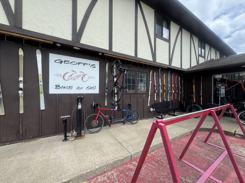
My front tire had gotten super squishy by the end of the day. From feeling a little bit low the day before, it had continued to get lower throughout the day — but I was enjoying the extra “suspension” on the sometimes heavily cracked roads. And as long as it wasn’t going completely flat, I figured it would make more sense to make it to the end of the day and fix it at the hotel or a bike shop if I could find one. My dad had called to see how I was doing, and I told him my front tire was going flat. I have everything I need to fix a flat, but after riding tubeless through so much debris, who knows how much junk is embedded in the tire itself. I, of course, would have felt around the inside and pushed very hard for any sharp objects buried, but I didn’t want to do that on the side of the road as long as I could still ride. And the advantage of going to a bike shop would be that I could keep the tire tubeless by having them reseal it with an air compressor.
I had already entered Google Maps directions for a bike shop in Iowa City, but my dad called back with the address of the same shop. Once I made it to Geoff’s Bike Shop, I borrowed a floor pump, and the tire was down to 10 psi. Even though it was super busy, the friendly mechanic quickly took my tire off, saw that it still had plenty of sealant, pumped the tire back up, and said I should be good to go … no charge … and the tire held the remaining 1000 miles of the trip. I still don’t know why/how the tire could have gotten so low over the span of a day without me seeing any sealant leaking. I expect it has something to do with a slow leak that opened up each time I was hitting the ice cracks on the bike trails and roads.
In any case, it was a great experience and I was very thankful to be on my way in just a few minutes so that I could then bike back northwest to Coralville where I had booked a hotel. This took me straight through the heart of the University of Iowa campus, which was a nice fun way to end the day.
Day 16: Crossing the Mississippi River and turning South
Iowa City, Iowa to Quincy, Illinois
Wednesday, June 25th, 2025 @ 4:45am
182.2 mi, 5,203 ft climbing, 13hr 32min
https://www.strava.com/activities/14917659449
173 vehicles, 1.8/mi, 0.4/min, 41.7mph(avg), 81.2mph(max)
https://www.mybiketraffic.com/rides/view/405793
After an early start and a nice hotel clerk who let me grab some food from the free continental breakfast area long before it officially opened, I saw both on the radar and the sky that there was a line of storms approaching from the west. It looked like there was a chance if I rode fast enough, I could get clear the line of storms to the south. I rode fast through mostly deserted streets and caught up to two University of Iowa cyclists riding, too. They turned but I kept going straight. When it became abundantly clear by both lightning and rain that I wasn’t going to clear the storm, I figured I would find a good sheltered place to hunker down for 15-20 minutes or however long it took to pass.


I found a nice overhang from one of the University of Iowa basketball gyms (I think) where I could just relax and catch up on life on my phone and watch the rain. I had made it a grand total of 6.5 miles from the hotel. Ironic to be somewhat sleep deprived waiting out a thunderstorm 6.5 miles from a hotel room that I could still be in sleeping. Still, I was happy to have gotten on my way while it was still dry and found a dry place to wait it out. After about 45 minutes, it was still raining but the lightning had quieted down and it looked like there was a short break before the next part of the storm arrived.
So I took off and headed nearly due south into the wind, which thankfully wasn’t too bad and was even a crosswind the wrong direction (from the east) given how it had been blowing from the south/southwest for so many days. Roads were soaked and traffic was moderate, but I made my way out of the busier Des Moines area and southern suburbs and into the hills south of Des Moines passing through a town literally called “Hills” just ahead of the storm with very dark skies filling the roadway behind me.
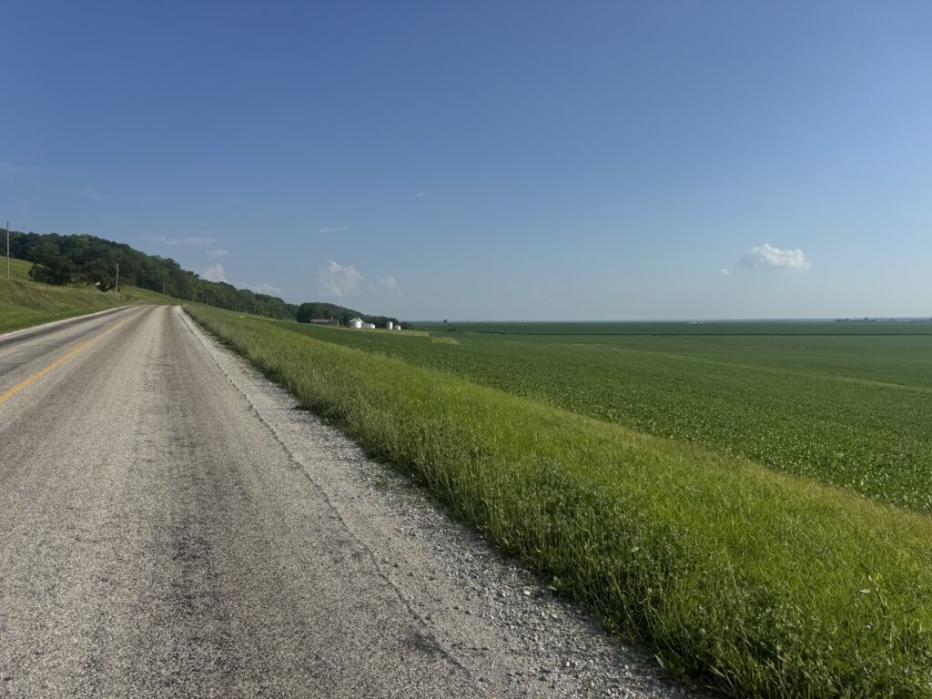
I followed the bluffs of the Iowa River all the way down through Columbus Junction eventually making it down to the wide flood plain of the Mississippi River valley still 10-15 miles away from the river. This was an interesting road because it hugged the bluffs and stayed hilly — presumably to stay high enough out of most of the floodwaters should the river flood. It was interesting to see the houses even farther up and only on the bluff side of the road with only farmland on the river side of the road.
It got very hot, and the road got very busy as I made it into the outskirts of Burlington where I could first see the river and crossed it into Illinois on US Highway 34. This was significant for a number of reasons – I had made it to the Mississippi River, and I had made it to the next major US highway crossing the country. I had been following US Hwy 30 all the way across Nebraska and had left it early the day before and had now worked my way south to the next highway. The US East-West highway systems increase in number as you get closer to the Gulf Coast with US Hwy 98 at the very bottom. I didn’t have to make it that far south though as the US Hwy 78 corridor from Birmingham veering north all the way to Memphis was my southern highway goal. It was a nice landmark marking my progress back home.
The Illinois side of the river was frying pan flat and frying pan hot with lots of trucks. The shoulder wasn’t great either, but it was fine. It stayed busy but I lost some of the traffic as I turned west to follow the river. In one historic town, I got caught on the wrong side of the train tracks checking out its frontage road immediately alongside the river, but thankfully it was a short/fast train. At the next town, there was a very narrow bridge all the way across the river back into Iowa which I immediately decided to cross to add an additional Iowa county as well as an additional crossing of the Mississippi River by bicycle.


This continued for the rest of the day as I followed the river down to Quincy crossing the river again back into Iowa at the Keokuk bridge under construction during rush hour … not great. As it turns out, that was right at the confluence of the Des Moines River and the Mississippi at a tri-state point in the river where Missouri, Iowa, and Illinois all meet.


The top of this post which I will quote again below happened through this next section. I made it to a very scenic road with some scenic parks alongside and bluffs overlooking the river. The road eventually became pretty rough chip/seal and that’s where I ran out of water.
As an example of the juxtaposition of misery and beauty, I was riding along the east side of the Mississippi River on a road that was kinda rough and hilly and still into that hot headwind even getting towards the end of the day when I ran out of water. I checked Google Maps, and the nearest gas station was almost 10 miles away with another 15 miles after that to get to Quincy where I was spending the night. But the view of the river beside me, and the light of the sun already starting to get lower on the horizon on the trees along the river and the steep bluffs was phenomenal. It was hard to despair in such beauty so I just kept plodding along slowly into the wind on a bumpy chip/seal road, miserable with saddle sores from storms that had soaked me earlier in the day. An hour or so after the gas station, traffic got busy as I finally made my way into Quincy and to the hotel with an amazing view of the Mississippi River. After getting checked in and taking a quick shower, it was 8:55pm. There was only one restaurant still open within a few blocks of my hotel, but after walking in at 9:01pm, the waitress said, “Sorry, we just closed”. Of course.
Day 17: Adventures (and traffic) and cramps along the Mississippi River
Quincy, Illinois to St Charles, Missouri
Thursday, June 26th @ 6:02am
128.8 mi, 5,456 ft climbing, 10hr 24min
https://www.strava.com/activities/14926818437
281 vehicles, 7.5/mi, 1.6/min, 48.2mph(avg), 82.9mph(max)
https://www.mybiketraffic.com/rides/view/426679
It was the best of times, it was the worst of times. Missouri ranks near the very bottom of bicycling safety in the entire country (#49). And it’s easy to see why. I’ve had some great rides in Missouri, but there is always a point of the ride where I am dealing with insane bicycle unfriendly traffic.


This day started out great. I crossed into Missouri over the Mississippi River on US Hwy 24 (one of the “out-of-place” US highways that dips far south on its run from Michigan to Colorado). This eventually merged with US Hwy 61 and became like an interstate with overpasses at the major intersections. But bicycles were allowed and the shoulder was good for riding. The trucks drove very fast, though. Intersecting with US Hwy 61 was another major landmark with the goal of making it back home to US Hwy 31 through Birmingham. As a side note, US odd numbered highways run north to south, startoing with US Hwy 101 in California and decrease in number as you head east with US Hwy 1 being the farthest east running up the Atlantic seaboard. US Hwy 61 is extra special because it also goes North to family in the Twin Cities area. I could have literally turned right and a couple days later showed up at my brother and sister-in-law doorstep!


My first destination for the day was the other direction, though, south to Hannibal, Missouri – birthplace of Samuel Clements (Mark Twain). This was at the recommendation of my good friend Stephen Peters who had been there before and said it was worth the detour. It definitely was!
I had delayed my start a bit to make sure it was daylight by the time I made it to Hannibal since it was only about 20 miles from my hotel in Quincy and so I could stay for the free hot breakfast at the hotel. The route was quite hilly with big Mississippi River bluffs. Before making it to the downtown area, I rode through the Mark Twain overlook park with the statue of Samuel Clements overlooking a fantastic view of the Mississippi River.


Afterwards, I dropped down into the city itself at river level. The entire town is pretty much a museum for Mark Twain with everything annotated with what it was in Mark Twain’s time growing up there. I walked my bike through the boyhood home back/front yard as it was a pedestrian path. I was thankful I could see so much without having to lock my bike up outside somewhere or wait for a museum to open. It was great, and I’m looking forward to taking my family back there some day.
Especially, since I missed an entire river bridge crossing of the Mississippi River at the next town farther south in a town named Louisiana, Missouri. I-72 crosses at Hannibal itself, and that is off limits to bikes, but Louisiana (the city) has a bikeable crossing of the river from a town high on the bluff to the other side at river level. I was getting hot and the sun was getting hotter, and for whatever reason I just couldn’t bring myself to drop a couple hundred feed down to the river and then have to climb back up on a busy bridge. I regretted it within a few miles and almost turned back, but it was too late.
I’m glad I didn’t because it stayed hot and hilly but thankfully (and surprisingly) not much traffic at all on the state highway I took south for many miles … that is until I got about 30 miles away from the suburbs of St Louis … probably still 60 miles away from St Louis itself. The state highway (79) I was on got busier and busier from Elsberry and even more so at Winfield, Missouri. In between these towns I had stopped at the Dollar General in Foley, Missouri in desperate need of electrolytes to fight off cramping which I could tell I was right on the edge of. While I was waiting in line with my Gatorlyte drinks, I had a full leg lockup cramp. I was thankfully able to keep calm and keep it from progressing to other muscles and it eventually released. I was able to check-out and then immediately down the drinks as soon as I made it back outside.
I was quite despondent through here knowing I still had 30 more miles to ride in the heat and traffic and was going to have to ride oh so slowly to keep from having a leg lockup while riding. Thankfully I was able to get off the busy state highway and take parallel roads up on the bluff but that meant some pretty steep climbing to get there. I crawled up them in my easiest gear on my loaded bike and fought off many more cramps at an average speed of 10mph.


Once I made it to the St Charles area, the suburb of St Louis where I had booked a hotel, it was 5 o’clock rush hour traffic. And it was bad. But the frontage roads I ended up on right next to the interstates had a decent enough shoulder in most places (but not all places) that it wasn’t terrible. Eventually, I made it to the hotel where I walked carefully to a nearby drug store (closer to the hotel than gas station) to buy even more Gatorlyte drinks and try and replenish my dehydrated body after only riding 128 miles on the day.
Day 18-19: Dirt roads, detours, and hills leaving the river, heading into the Missouri boot
St Charles, Missouri to Kennett, Missouri via Farmington hills
Friday, June 27th, 2025 @ 3:08am and Friday, June 27th, 2025 @ 11:12pm
100.0.mi, 5,587 ft climbing, 8hr 17 min (1st ride)
170.9mi, 4,865 ft climbing, 12hr 38min (2nd ride)
https://www.strava.com/activities/14934158211
https://www.strava.com/activities/14945464931
575 vehicles, 5.8/mi, 1.2/min, 36.0mph(avg), 86.5mph(max)
https://www.mybiketraffic.com/rides/view/407266
411 vehicles, 2.4/mi, 0.5/min, 45.2mph(avg), 74.4mph(max)
https://www.mybiketraffic.com/rides/view/426669
Day 18 started with a super short day of only 100 miles with lots of climbing on the Mississippi River bluffs after cramping so hard the day before. Also, I wanted to basically take an afternoon nap at the hotel and get started again early to get some serious night miles to avoid the heat and still get some good distance covered on Day 19.
I made my way through the outer suburbs of St Louis in the dark early morning to make it to the Gateway Arch by sunrise and before busy rush hour traffic. It was fairly quiet and totally worth it!


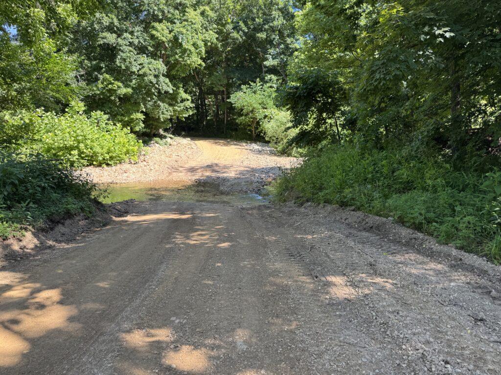
I had used ridewithgps routing to get me from St Charles to Farmington Hills only about 100 miles away. I wanted to be at the St Louis arch at sunrise and given the heat from the day before and the soaring temps again expected in the afternoon, I needed a short day. Unbeknownst to me, ridewithgps had taken me on some rural dirt roads that were so awesome. They were very hilly, but they were tree lined in the shade. Eventually, I made it out of the dirt and onto a very busy county road (County Highway D) that I was on for many miles to make it to Farmington. Drivers were actually mostly fine, but the road was busy and hilly and it was difficult for them to pass (no shoulder at all).


I made it to Farmington by early afternoon, and after checking in, walked across the street to a family diner where I had a very nice breakfast for dinner at lunchtime. After a few hours asleep at the hotel, I was on my way again by 11pm.
The Mississippi River had veered far to the east whereas my route to Farmington had taken me quite a ways to the west. So I started out this night riding for many miles until nearly sunrise finally making it back to the river at Cape Girardeau. I crossed the bridge there back into Illinois, but then immediately turned around and crossed it back into Missouri a little less than halfway through the day’s riding by sunrise.
I spent nearly all day on a variety of busy state highways with lots of farming trucks. Shoulders were hit or miss. Sometimes it was great, sometimes it wasn’t. Eventually, I made it to the very cheap ($60) hotel in Kennett by 2pm. Check-in wasn’t until 3pm so he charged me an extra $25 to check in even though I would be leaving the hotel again only a few hours later. I wasn’t going to protest, though, or figure out a way to kill the time until 3pm because I was beat by the rising heat. I guess I could have just waited in the lobby for a bit, but I really wanted to shower and enjoy the gas station food I had bought for my 2pm dinner. So I paid the extra $25.
And that brings me to the end of Part 3. I’ll save the final few days of riding through Arkansas, Tennessee, Mississippi, and Alabama for Part 4. It starts out with a presumably drunk person screaming at me at the top of their lungs somewhere out in the middle of rural farmland near the Arkansas border.
Leave a Reply